|
Author
|
|
Rose
Senior Member
Registered: August 2002
Posts: 498
|
|
Sun December 12, 2004 11:52pm
|
|
|
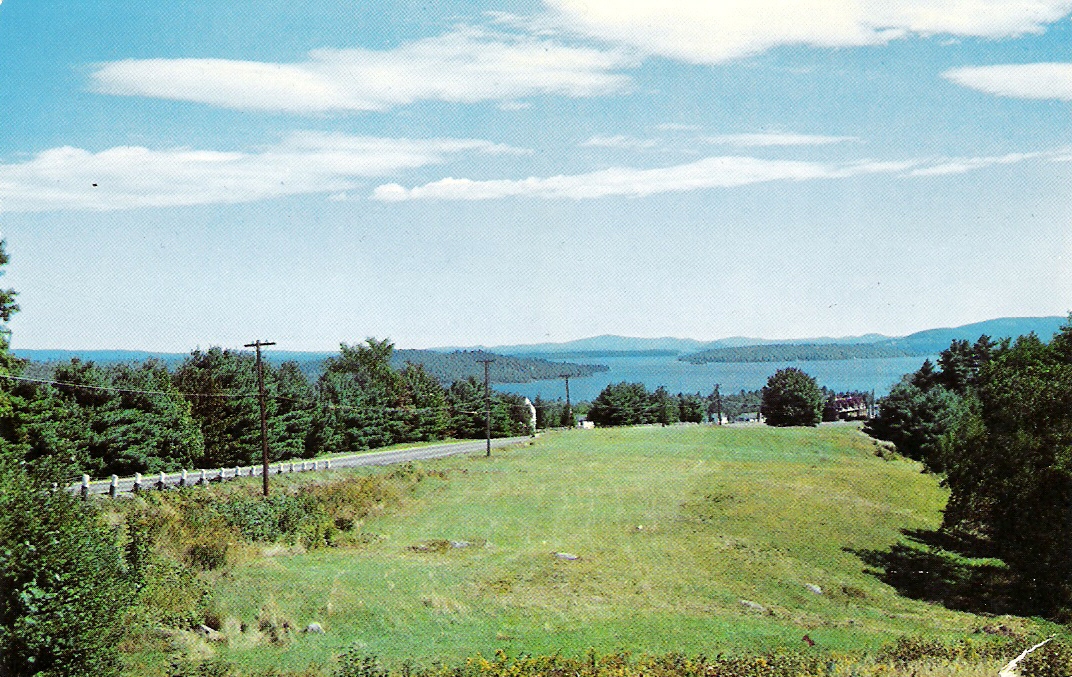
Is it Route 3 between the Weirs and Meredith, many, many moons ago?
|
|

|
|
mcdude

Senior Member
Registered: July 2002
Location: Rock Haven Lake - West Newfield, ME
Posts: 5,367
|
|
Mon December 13, 2004 1:33am
|
|
|
Nope....but you have two more guesses!
------------------------------
|
|
|
|
|
salesguy77
Junior Member
Registered: June 2004
Location: Bedford NH Laconia NH
Posts: 23
|
|
Thu December 16, 2004 6:36pm
|
|
|
It looks like Route 11 going toward Alton. Possibly Rattlesnake island on the left?
------------------------------
A little common sense goes a long way. If you have to think about it, or tell yourself it's a good idea, then it probably isn't a good idea!
|
|
|
|
|
mcdude
Senior Member
Registered: July 2002
Location: Rock Haven Lake - West Newfield, ME
Posts: 5,367
|
|
Thu December 16, 2004 11:11pm
|
|
|
It's somewhere more in between Alton and Meredith....but it is Rt. 11! (And remember this postcard is probably 30 or more years old.)
------------------------------
|
|
|
|
|
JacksonB

Senior Member
Registered: April 2004
Location: Alton Bay/CT
Posts: 222
|
|
Sat December 18, 2004 12:18am
|
|
|
I don't know of any place that Route 11 is that high above the lake between Alton Bay and Weirs. That appears to be Spindle Pt. on the left and Eagle Is. in front of Governor' Is. on the right. I'm with Rose.
|
|
|
|
|
upthesaukee

Senior Member
Registered: January 2003
Location: Alton Bay
Posts: 5,600
|
|
Sat December 18, 2004 5:18pm
|
|
|
Geez, it sure looks like rte 3, which maybe was rte 11 back in those days, but then again none of us are as old as McDude. The gabled building in the extreme right center of photo I think is still there, in bad repair. I gotta go with Rose and JacksonB.
------------------------------
I Live Here... I am always UPTHESAUKEE !!!!
|
|
|
|
|
mcdude
Senior Member
Registered: July 2002
Location: Rock Haven Lake - West Newfield, ME
Posts: 5,367
|
|
Sat December 18, 2004 6:35pm
|
|
|
....as old as the hills and feel it some days too! The back of the card says, "General view of Lake Winni from U.S. Rt. 3 approaching Laconia, NH."...so I'm thinking it is the Laconia Bypass which is Rt. 3 & Rt. 11 coming down the big hill (actually in Gilford) approaching Lily Pond and the airport but the more I look at it I'm not so sure. (And, of course, since I am so old my memory is failing a bit!!!) The card is postmarked 1956 so things may have changed a bit in almost 50 years.
------------------------------
|
|
|
|
|
CEP
Senior Member
Registered: November 2004
Location: Charlton City,MA
Posts: 110
|
|
Sun December 19, 2004 2:37pm
|
|
|
My vote is with Rose and JacksonB.
I see Eagle I. and Govenors' I. and Meredith Neck.
My memory is a little bit gone to but I think at the bottom of the hill and to the left, there was or still is a boat repair place with a lot of old boats for sail. I stopped there one time, many, many, moons ago and the guy who owned the place had the old wooden boat,"Foxy", and he was restoreing it.
Also, a little further down looks like there might have been an old golf driving range, that is now all grown over.
Am I right or should I look into an old age home???HEHEHE!
CEP
|
|
|
|
|
Tallyho

Senior Member
Registered: June 2006
Posts: 312
|
|
|
It has to be route 3, I don't think the Laconia bypass was there in 1956!
|
|
|
|
|
carguy

Senior Member
Registered: August 2006
Location: Norwich, CT
Posts: 199
|
|
Sun August 13, 2006 2:44am
|
|
|
My vote is with Rose and Jackson B. You can see Spindle Point, Eagle Island, and Governor's Island. Far to the right is the building that in now the Antique Marketplace. It has to be RTE 3 between the Weirs and Meredith.
------------------------------
Best Regards,
Carguy
Norwich, CT 06360
|
|
|
|
|


 Winnipesaukee Forum