Home Forums Gallery Webcams Blogs YouTube Channel Classifieds Calendar Register FAQDonate Members List Today's Posts

  Home · Search · Register  

Home » Historical Photographs » Postcards Previous image   Slide Show   Next image
more
westaltontent.jpg
Wolfeboro-1910-Hobbs_Landing.jpg
winniaerialmap8-9-2009_6_01_46_PM.JPG
20scanglimpseofcenterharbor.jpg
9DSC06916-1024w.jpg
more

Winni Aerial Map Postcard
Click on image to view larger image


Photo Details
mcdude


Senior Member

Registered: July 2002
Location: Rock Haven Lake - West Newfield, ME
Posts: 5,367
users gallery
This large size postcard is available at the bookstore at Mills Falls and at Amylynne's Busy Corner Store in Alton produced by http://www.skytopimages.com
I especially like it because it shows all the lakes in my neighborhood (over the "NIP" in winnipesaukee) which are usually cut off of must winni maps.

From left to right they are;
Manning Lake in Gilmanton http://mysite.verizon.net/vze3nm2c/c...glake/id9.html

Lake Eileen which is within the Hidden Valley Scout
Reservation http://en.wikipedia.org/wiki/Daniel_Webster_Council

Sunset Lake which straddles the Alton/Gilmanton town line

and to the northeast of that; Hills Pond

http://www.sunsetlakehillspond.com

One can clearly see Straightback Mountain and Mt. Major to the north of Hills Pond
· Date: Mon August 10, 2009 · Views: 7311 · Filesize: 32.0kb, 7033.6kb · Dimensions: 2055 x 1662 ·
Additional Info
Print View
Linked Thumbnail:  more


Author
Thread  
Rattlesnake Gal

Senior Member

Registered: November 2003
Location: Central NH
Posts: 5,252
Fri August 14, 2009 8:22pm

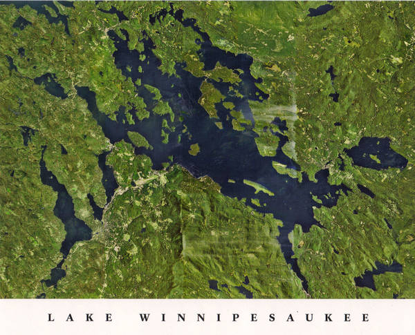
Too bad they did not include Hall's Pond. ;-)

Very cool postcard.
This user is offline
Click here to see this users profile Click here to Send this user a Private Message Visit Rattlesnake Gal's homepage! Find more posts by this user Visit this user's gallery  
Merrymeeting

Senior Member

Registered: March 2003
Location: Merrymeeting Lake, New Durham
Posts: 2,226
Wed August 19, 2009 2:06am

I can see my house from here! (lower right, far right).

www.mmlake.org
This user is offline
Click here to see this users profile Click here to Send this user a Private Message Visit Merrymeeting's homepage! Find more posts by this user Visit this user's gallery  
ApS

Senior Member

Registered: January 2005
Location: Florida (Sebring & Keys), Wolfeboro
Posts: 5,938
Mon December 14, 2009 11:18am

Oh, sure.


In the center, to the far right, is Lake Wentworth with The Nature Conservancy-owned "Stamp Act Island" in the middle of it. (Open to the public for touring by foot). Crescent Lake, an upside-down "Casper the Ghost", is just to its left.


That's "Dan Hole Pond" at the very top right. Its SE margin can be seen shored-up by one of the many craters of long-extinct volcanoes in the ancient Ossipee Mountain Range. Before the scouring by North American glaciers, Mt. Shaw is said by geologists to have been higher than Mt. Everest is today.

------------------------------
Is it
"Common Sense" isn't.
This user is offline
Click here to see this users profile Click here to Send this user a Private Message Visit ApS's homepage! Find more posts by this user Visit this user's gallery  


Photo Sharing Gallery by PhotoPost
Copyright © 2007 All Enthusiast, Inc.


All times are GMT -5. The time now is 08:22 PM.


Powered by vBulletin® Version 3.8.11
Copyright ©2000 - 2025, vBulletin Solutions Inc.