

|
|
|
|
|
|||||||
| Home | Forums | Gallery | Webcams | Blogs | YouTube Channel | Classifieds | Calendar | Register | FAQ | Donate | Members List | Today's Posts | Search |
 |
|
|
Thread Tools | Display Modes |
 09-09-2011, 09:15 AM
|
#1 |
|
Senior Member

Join Date: Jul 2002
Location: Massachusetts
Posts: 336
Thanks: 0
Thanked 243 Times in 82 Posts
|
For what should Bizer be looking?
As many of you know, Bizer spends a week in September surveying the lake. Bizer will be staying on Dow Island through next Wednesday. We shall be checking for updates to our chart of the lake. If you know of anything that you think we should examine, please post it here or email us at updates@bizer.com. We are looking for such items as
|

|

|
|
09-26-2011, 11:16 AM
|
#2 |
|
Senior Member
Join Date: Jul 2009
Posts: 61
Thanks: 42
Thanked 35 Times in 14 Posts
|
Sorry I missed your survey timing. I noticed a buoy missing and reported it to the Marine Patrol about 3 weeks ago. I beleive it was a black buoy on the north side of Sandy Island (right off the shore of Sandy Island as it faces Long Island). It appears on the Bizer chart but I've been past there several times and don't see it. There are two on the chart along that side of the island but I only see one in the water.
Anyway, just sharing that info. Sorry I don't have a more specific description as I write this. The Marine Patrol never got back to me and I haven't been up that way since the day I reported it so I haven't been able to confirm whether I'm crazy or . . . crazy observant. 
|
|
|
|
|
09-26-2011, 02:17 PM
|
#3 |
|
Senior Member

Join Date: Apr 2004
Posts: 5,075
Thanks: 215
Thanked 903 Times in 509 Posts
|
My Bizer chart shows a red marker right off Sandy Point.The black marker is shown as FL 23.There should be a black about halfway from Sandy to the bandstand though.
__________________
SIKSUKR |
|
|
|
|
09-26-2011, 05:19 PM
|
#4 |
|
Senior Member

Join Date: Apr 2004
Location: Bear Island
Posts: 1,764
Thanks: 32
Thanked 441 Times in 207 Posts
|
Is it possible to make the Bear Island NWZ more obvious on your map?
In the last couple of years I have noticed a sharp increase in the number of people violating the NWZ. I have been able to wave a few of them down and ask them what they were doing. It each case they tell me they had no idea there was a NWZ between Pine and Bear. The map only has a four small orange dots to indicate the NWZ. Even then you must check the legend to see what they mean. Is is possible to shade in the zone or make it a different color? Or perhaps add the words "No Wake". Actually I think the principal reason for so many violations is the small no wake markers that people do not notice or can not read. Not that many years ago the marker near the point of Bear Island was a large metal buoy with large circular "No Wake" signs on each side. It was impossible to miss and easy to read from a distance. Since that has been removed I think many newcomers just don't know there is a NWZ there. Thanks |
|
|
|
|
09-26-2011, 07:25 PM
|
#5 |
|
Senior Member
Join Date: Jun 2009
Posts: 118
Thanks: 0
Thanked 14 Times in 11 Posts
|
Agree with Bear Islander. Shading the no wake zones would be a nice addition.
|
|
|
|
| Sponsored Links |
|
|
|
09-27-2011, 08:34 AM
|
#6 | |
|
Senior Member
Join Date: Apr 2004
Posts: 5,075
Thanks: 215
Thanked 903 Times in 509 Posts
|
Quote:
__________________
SIKSUKR |
|
|
|
|
|
09-28-2011, 06:01 PM
|
#7 |
|
Senior Member
Join Date: Feb 2007
Posts: 233
Thanks: 14
Thanked 16 Times in 12 Posts
|
Might I kindly suggest making the chart "red-light readable"? Essentially it would only entail changing the color of everything that is red to red-brown.
I discovered it wasn't this summer one night while trying to figure out where all the red buoys went!  And you could advertise your charts as "red-light readable." At the very least, it sounds cool! 
__________________
Sail fast, live slow! |
|
|
|
|
10-06-2011, 07:19 AM
|
#8 | ||||
|
Senior Member
Join Date: Jul 2002
Location: Massachusetts
Posts: 336
Thanks: 0
Thanked 243 Times in 82 Posts
|
Hmmm. When I posed this question in 2009, there were eight replies. There were no replies for to this thread for seventeen days, although I did receive four private messages/emails.
Quote:
Quote:
Quote:
I walk a fine line here. Many people tell me that they prefer the other map because Bizer's chart has too much information (i.e. cluttered). This is one more piece of clutter. Quote:
Here are some other items of interest that I discovered the week of September 11th: The barbers' pole ornament that was set in 2001 was absent last year and this year. Unless someone has some reason to believe that it will be replaced, Bizer will remove it from its next edition chart. The buoys north of Two-Mile Island have been substantially reconfigured. Of the seven buoys that were there in 2007, one has been removed and five others have been reset in a new configutation. Only one of the seven buoys had not moved. There are only three no-wake buoys marking the entrance to Meredith docks. Last year there were four, prior to that, there were five. One half mile east of Meredith Marine, Duncan Press shows a 12 foot depth while Bizer shows the depth to be 55+ feet. As a result, Duncan's web page calls Bizer's depth information, "well-meaning but amateurish". In the interest of accuracy, Bizer investigated and could find no depth less than 45 ft in this area so there will be no changes. One of the red-and-white buoys southeast of Big Island has been reset over 500 feet from its former position. The red-and-white buoy just south of Ledge Island has moved (or been reset) about 80 feet. Someone informed Bizer that they travel slightly north of Eagle Island to avoid the NO-WAKE zone southeast of Eagle Island. In the past, Bizer had never encountered anything less than 3.5 feet below low lake. Upon more investigating, Bizer found two rocks less than three feet below low-lake, one of the rocks is only 15 inches below low-lake. These, along with about 5 other newly found rocks, will appear on Bizer's next edition. Last edited by Bizer; 10-07-2011 at 07:02 AM. |
||||
|
|
|
| The Following User Says Thank You to Bizer For This Useful Post: | ||
Colby (10-06-2011) | ||
|
10-06-2011, 09:04 AM
|
#9 |
|
Senior Member

Join Date: Nov 2003
Location: Central NH
Posts: 5,252
Blog Entries: 1
Thanks: 1,451
Thanked 1,349 Times in 475 Posts
|
Great job on doing your research and making Bizer Maps the best they can be! It really is great that you get such good feedback from boaters that use the lake.
Bizer, I'm just wondering... if people are complaining about having so much information on your maps and that is why they choose the "other" chart, why not publish two versions of the Bizer map and give the people what they want? Obviously you would have to really label the less detailed map with a disclaimer of some kind, warning them about the lack of super-fine details. A different color scheme altogether would be smart too. Would this be of value?: For years I have been wanting to snorkel various buoys and hazards around the lake to document exactly what is there and the exact location. (For some reason, the marker south of Treasure Island is of great interest to me.) I've got the waterproof camera bag for my Nikon Cool Pix and a FlipShare video camera with waterproof case. I haven't found someone that has time to do such a project on calm days during the week, for less boat chop. Snorkeling by myself just isn't smart. Maybe next year I can make this happen. The water is just too cold right now for this gal. ________________________________________
Once updates have been made and the new map is in production, be sure to support both  and  by purchasing your map through the  ________________________________________  Lake Winnipesaukee Folded Chart Bizer 8th Edition Waterproof folded Chart of Lake Winnipesaukee (23"x35") From Bizer Lake Maps (If I am not mistaken, next year's map should be the 9th Edition.) ________________________________________ Also, be sure to visit the at Cafe Press A sampling of the goodies:          Christmas is coming!  |
|
|
|
| The Following User Says Thank You to Rattlesnake Gal For This Useful Post: | ||
GsChinadoll (10-06-2011) | ||
|
10-06-2011, 10:56 AM
|
#10 |
|
Senior Member

Join Date: Apr 2010
Location: Northern MA & Moultonboro
Posts: 54
Thanks: 339
Thanked 15 Times in 7 Posts
|
Didn't even know there was a Winnipesaukee.com store! Thanks RG!
__________________
Don't let people drive you crazy when you know it's within walking distance. |
|
|
|
|
10-11-2011, 06:21 PM
|
#11 |
|
Senior Member
Join Date: Feb 2007
Posts: 233
Thanks: 14
Thanked 16 Times in 12 Posts
|
Bizer,
I printed out the picture in this post and looked at it under a red light. Everything looks great. Because the difference in printers, etc, you should still verify that the actual map that will be sold has visible red buoys under a red light. Heck, maybe you could even get your retailers to sell handheld red lights next to with your charts! Or red headlamps? The possibilities are endless. "Bizer's charts save your night vision!"  Something like: 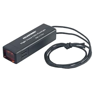 http://www.amazon.com/Celestron-9358...8374805&sr=8-2
__________________
Sail fast, live slow! |
|
|
|
|
10-11-2011, 06:58 PM
|
#12 |
|
Senior Member
Join Date: Feb 2007
Posts: 233
Thanks: 14
Thanked 16 Times in 12 Posts
|
In the interest of procrastination, here is an illustration of my point for your viewing pleasure. For those that don't know, red lights do not affect your night vision nearly as fast as an equally bright white light. Unfortunately I do not have a Bizer chart here with me.
The problem...when whatever you're looking at is exactly the same color as your red light...   ...it disappears! Very scary when you fly (at no more than 25mph) past 4 red buoys that "aren't on the map!"
__________________
Sail fast, live slow! |
|
|
|
|
10-11-2011, 08:02 PM
|
#13 |
|
Senior Member
Join Date: Sep 2010
Location: Nashua, NH
Posts: 66
Thanks: 27
Thanked 16 Times in 6 Posts
|
Just had to throw it out there...
The Bizer charts in the LakeWinni iPhone/iPad app have a "night mode" that let you view it with a darker, red light: 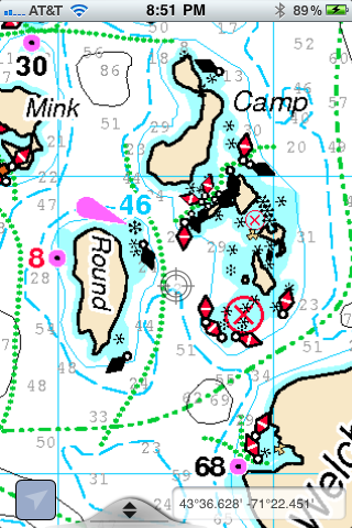 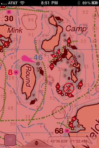 ...just sayin'
|
|
|
|
|
10-12-2011, 08:24 AM
|
#14 |
|
Senior Member
Join Date: Apr 2004
Location: NH
Posts: 2,689
Thanks: 33
Thanked 439 Times in 249 Posts
|
Too bad that app isn't available for the Android...
|
|
|
|
|
10-14-2011, 11:38 AM
|
#15 | ||
|
Senior Member
Join Date: Jul 2002
Location: Massachusetts
Posts: 336
Thanks: 0
Thanked 243 Times in 82 Posts
|
Quote:
Quote:
Other: I have verified that the buoy on the north side of Sandy Island is still missing. It will be part of my letter to the Marine Patrol over the winter. Last edited by Bizer; 10-15-2011 at 09:35 AM. |
||
|
|
|
|
10-14-2011, 12:06 PM
|
#16 |
|
Senior Member
Join Date: Jan 2003
Location: Alton Bay
Posts: 5,596
Blog Entries: 2
Thanks: 2,453
Thanked 1,979 Times in 1,080 Posts
|
Here is a link to Garmin's website's dissertation on the accuracy of GPS.
Maybe this will either fuel your fears of the level of inaccuracy, or alleviate them.  http://www8.garmin.com/aboutGPS/waas.html
__________________
I Live Here... I am always UPTHESAUKEE !!!! |
|
|
|
|
| Bookmarks |
|
|


 Linear Mode

