

|
|
|
|
|
|||||||
| Home | Forums | Gallery | Webcams | Blogs | YouTube Channel | Classifieds | Calendar | Register | FAQ | Donate | Members List | Today's Posts | Search |
 |
|
|
Thread Tools | Display Modes |
 03-09-2011, 02:44 PM
|
#1 |
|
Senior Member

Join Date: Apr 2006
Location: Central MA-Gilford
Posts: 1,446
Thanks: 340
Thanked 119 Times in 96 Posts
|
Does anyone know the actual legal recorded name for 'Gunstock Mtn' ?
I know it is part of the Belknap mountain range, but never knew if Gunstock Mtn (ski area), has an actual name recorded either by the State, County or Fed Govt. GSA agency? Thanks, BD |

|

|
|
03-09-2011, 02:45 PM
|
#2 |
|
Senior Member
Join Date: Aug 2010
Posts: 69
Thanks: 14
Thanked 30 Times in 11 Posts
|
|
|
|
|
|
03-09-2011, 03:45 PM
|
#3 |
|
Senior Member
Join Date: Apr 2006
Location: Central MA-Gilford
Posts: 1,446
Thanks: 340
Thanked 119 Times in 96 Posts
|
Did some research, and found in the following link for Belknap Mountain,
it actually refers to 'Gunstock' mountain, as part of the Belknap Mtn range. So I guess that's the official mountain name. Belknap Mountain http://www.ask.com/wiki/Belknap_Mountain FYI.... Belknap Mtn was Named after Jeremy Belknap (17441798), a renowned preacher, historian, and author,of The History of New Hampshire. Gunstock Mtn - Wikipedia http://www.ask.com/wiki/Gunstock_Mountain FYI - List of mountains of New Hampshire ( listed by height) http://www.ask.com/wiki/List_of_moun...hire?qsrc=3044 Who knew there were so many ! BD |
|
|
|
|
03-09-2011, 10:11 PM
|
#4 |
|
Senior Member

Join Date: Apr 2004
Location: Wolfeboro
Posts: 521
Thanks: 10
Thanked 29 Times in 15 Posts
|
The ski area was called Belnap in my youth. It was then change to Gunstock. Anyone remember when this happend and why?
Did they move the area to another peak?
__________________
Home Permanently in NH
 |
|
|
|
|
03-10-2011, 05:36 AM
|
#5 |
|
Senior Member
Join Date: Jan 2010
Posts: 620
Thanks: 259
Thanked 158 Times in 100 Posts
|
I believe Belknap was the old ski area where the ski jumps are. They even closed the road off, except when they were rebuilding the bridge into Gunstock.
|
|
|
|
| Sponsored Links |
|
|
|
03-10-2011, 08:14 AM
|
#6 | |
|
Senior Member

Join Date: Jul 2002
Location: Rock Haven Lake - West Newfield, ME
Posts: 5,367
Thanks: 374
Thanked 1,057 Times in 495 Posts
|
Quote:
http://www.nelsap.org/nh/mountrowe.html but the confusion arises because it was known as the Belknap Mountain Recreation area but was actually originally on Mt. Rowe. In the postcard below Gunstock is on the left and Mt. Rowe is on the right.  " Anyone who has skiied Gunstock can recognize the basic configuration of the trail map. It has been much improved and expanded and the new quad lift brings you to the top in seven minutes! "Recreational area near Laconia, NH. Showing chair lift on Rowe Mt. (3,200 ft) in center and ski trails with 4 ski jumps 10- 20 - 40 - 65 meter; with 5 meter ski jump at right. Lake Winnipesaukee is background." 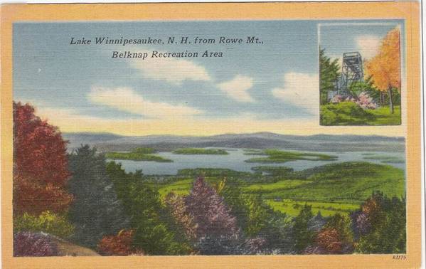     Phelps Slope, Belknap Mts., Recreation Area, Gilford, NH. "One of the most popular of the several ski slopes at the million dollar Belknap Mts. Recreation Area which is less than 100 miles from Boston and 7 miles from Laconia, NH on Route 11A". From the gunstock website, " Gunstock wasn't always about snow, lights, lifts and action. It took the vision of the Belknap County Legislators in 1935 to propose the "Belknap Mountain Recreation Area." On the heels of the Great Depression, Belknap Mountain was born of the WPA's (Works Progress Administration) New Deal program created during President FDR's administration. The project took three years to complete and employed 300 local workers. Amenities included ski trails, a single chairlift (one of only three in the east), rope tows, cross country trails, toboggan runs, sliding hills, a ski jumping complex, a campground, picnic area, base pond, nature trails and a base lodge and smaller buildings build to timber cut and stone quarried on-site.
__________________
|
|
|
|
|
| The Following 7 Users Say Thank You to mcdude For This Useful Post: | ||
bigdog (03-10-2011), Grant (03-10-2011), Jonas Pilot (03-10-2011), Overlake97 (08-29-2013), RailroadJoe (03-10-2011), Rattlesnake Gal (03-10-2011), SteveA (03-11-2011) | ||
|
03-10-2011, 08:57 AM
|
#7 |
|
Senior Member
Join Date: Apr 2006
Location: Central MA-Gilford
Posts: 1,446
Thanks: 340
Thanked 119 Times in 96 Posts
|
Mcdude,
Thank you SO much for all the historical info., much apprecaited! Although, I never skied Gunstock as a youth, I do remember it being called Belknap Mtn Recreational area. Now that I am a resident of Gilford (one whole year ! ), I have been skiing Gunstock and thouroughly enjoying the friendly atmosphere. I know the County owns and runs Gunstock ski area, and hope they continue to make improvements, but keep the small mtn. charm! BD |
|
|
|
|
03-10-2011, 09:59 AM
|
#8 |
|
Senior Member

Join Date: Jul 2002
Location: Pennsyltuckey, Tuftonboro, Moultonborough
Posts: 1,499
Thanks: 374
Thanked 229 Times in 123 Posts
|
__________________
"When I die, please don't let my wife sell my dive gear for what I told her I paid for it." |
|
|
|
|
03-10-2011, 01:45 PM
|
#9 |
|
Senior Member
Join Date: Apr 2004
Location: Wolfeboro
Posts: 521
Thanks: 10
Thanked 29 Times in 15 Posts
|
I know McDude would have the answer.
I can remember watching a major ski jumping composition there with my family. I also skied from the lift. I guess I'm showing my age.
__________________
Home Permanently in NH
|
|
|
|
|
03-10-2011, 05:55 PM
|
#10 |
|
Member
Join Date: May 2004
Location: Gilford, NH
Posts: 43
Thanks: 10
Thanked 10 Times in 4 Posts
|
To shed light on the acutal legal recorded name of Gunstock, you might want to start with the website maintained by the US Board of Geographic names. Do a domestic search on the feature name "Gunstock".
http://geonames.usgs.gov/pls/gnispub...57992::NO:RP:: There are some pdf files of old citation cards and decision cards used by the USGS to justify placenames. It is interesting to read those. One of the decision cards defines the Belknap Range as being only 3 mountains, with Gunstock being the most northerly one, Belknap in the middle, and Whiteface to the south. It seems that to get something named "officially" requires going through the US Board of Geographic Names. This is briefly discussed in this article on the movement to change the name of Mt. Clay to Mt. Reagan up in the Whites. http://www.boston.com/news/local/new...feats_of_clay/ |
|
|
|
|
03-10-2011, 09:06 PM
|
#11 | |
|
Member
Join Date: May 2009
Posts: 24
Thanks: 1
Thanked 32 Times in 8 Posts
|
Quote:
I'm not sure about the specific names of the mountains, but I don't think the postcard photo shows any of what was the "Mt Rowe Ski Area". I was a 1st grader when my family moved to the Lakes Region in the early 70's. I first learned to ski at "Mt Rowe Ski Area". None of the Mt Rowe ski area trails (of the early 70's) are shown on this photograph. The straight line path going to the right on the photo was a single chair chairlift, which was part of the Gunstock Ski Area. The winding trail to the right was called "Try Me", and was still open in the early 70's. The trail to the right of "Try Me", was closed in the early 70's, but I can recall skiing that (ungroomed) trail to get to the ski jump competitions that were still taking place at the time. If I recall correctly, the single chair lift was discontinued when Gunstock made "improvements" in the late 70's or early 80's. It never made sense to me (even as a kid) that Gunstock stopped using that part of the ski area. I'd love to hear from somebody that has more history of the mountain. It goes back way before my time, and it would be nice to have a "year by year" historical summary. (Would even make for a nice addition to the current Gunstock website!) |
|
|
|
|
|
03-10-2011, 09:21 PM
|
#12 |
|
Member
Join Date: May 2009
Posts: 24
Thanks: 1
Thanked 32 Times in 8 Posts
|
Just found a great link to Gunstock as I remember it, as a kid.
http://teachski.com/brochures/gunstock/gunstock.htm The "closed trail" tht led to the jumps was called "Fletcher's Hale" .... brings back memories! |
|
|
|
| The Following 2 Users Say Thank You to Ironfish For This Useful Post: | ||
Overlake97 (08-29-2013), Rattlesnake Gal (03-11-2011) | ||
|
03-10-2011, 11:41 PM
|
#13 |
|
Senior Member

Join Date: Nov 2002
Location: The Lakes, Central NH. and Dallas/Fort Worth TX.
Posts: 3,694
Blog Entries: 3
Thanks: 3,069
Thanked 472 Times in 236 Posts
|
We are all so very lucky to get to enjoy our many great Mountains here in the Lakes Region... " Noth'in Like it"!!!!
Now, not to date myself over here, I was on a pair of wooden ski's in my former days, late one evening when the left one broke sending me off the beaten path, ( so to speak ) where I got cut up pretty good from the frozen ice layer on top of the snow in the outer perimeters. Did I survive, Absotoothly!!  ... and maybe with a few other ( nuts and bolts loose ), as well. ... and maybe with a few other ( nuts and bolts loose ), as well.So, here I am further enjoying the Belknaps on a special afternoon with a view of a snow-sun-bow. http://www.winnipesaukee.com/photopo...9353&ppuser=83 T
__________________
trfour Always Remember, The Best Safety Device In The Boat, or on a PWC Snowmobile etc., Is YOU! Safe sledding tips and much more; http://www.snowmobile.org/snowmobiling-safety.html |
|
|
|
|
03-11-2011, 08:01 AM
|
#14 |
|
Senior Member
Join Date: Jul 2002
Location: Rock Haven Lake - West Newfield, ME
Posts: 5,367
Thanks: 374
Thanked 1,057 Times in 495 Posts
|
Here's a link to our forum friend, Boardwalk Bluesboy's website
http://www.weirsbeach.com/newmedia/12views/view11.html Lots of interesting pics of Mt. Rowe, Gunstock and the Belknap Mountain Recreation area. (even some pics of old bikers at the hill climb!) He also seems to think that Mt. Rowe was pictured on this card.....but....what do I know???  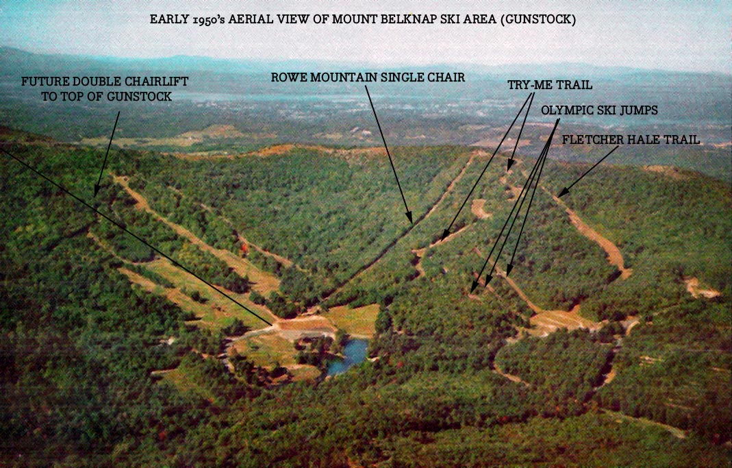 Boardwalk Bluesboy seems to indicate that the Mt. Rowe area was incorporated into the Gunstock Ski area at some point; "Gunstock trail map, in 1964, after the first double chair lift to the top of Gunstock had been built. A second double chairlift was added later to run alongside the first. The Rowe Mountain lift and trail complex were still a big part of the overall ski area. In 1986 a major reconstruction project changed the feel of the mountain, quite detrimentally in the opinon of the webmaster. Newer, less challenging trails and shorter lifts were added, while some challenging trails and longer lifts were removed. Notably, the two main double chairlifts to the top of the mountain were both removed and the middle part of the Ramrod trail which had ran underneath the main chairlifts was closed permanently. Much later, a new express quad chairlift to the top of the mountain was added to the left side of the Smith slope."
__________________
|
|
|
|
| The Following 3 Users Say Thank You to mcdude For This Useful Post: | ||
|
03-11-2011, 08:22 AM
|
#15 |
|
Senior Member
Join Date: Mar 2008
Location: Welch Island and The Taylor Community
Posts: 3,296
Thanks: 1,222
Thanked 2,080 Times in 952 Posts
|
Right you are Dude. We have hiked up Mt Rowe several times taking the path shown (I think) as the TRY-ME Trail which is now the access route to the cell tower. Also the old Rowe single chair lift line is still open as can be seen on Google Maps satellite views.
|
|
|
|
|
08-27-2013, 08:58 PM
|
#16 |
|
Senior Member
Join Date: May 2008
Location: Laconia
Posts: 479
Thanks: 545
Thanked 147 Times in 66 Posts
|
Historic Highlights" for Gilford Steamers 10 June 2004 issue
Its time to celebrate "Founders Day" Its mid-June, time for Gilfordites to think about celebrating "Founders Day." "Who exactly were the founders?" people often ask. Theres no simple answer to that question. If we can rely on legend, one name could be Greene Chase. To learn about this legend, we turn to Adair Mulligans words in The Gunstock Parish: A History of Gilford, New Hampshire. Greene Chase and two companions came up from lower Gilmanton to hunt cougar in what later came to be called Gunstock Mountain. They found tracks of a very large cat near the foot of the mountain. Chase, husky and a good woodsman, "...had just broken his snowshoe when the animal appeared suddenly on an overhanging ledge just above his head, whereupon his two companions fled with their dog. As Chase raised his musket to fire, the hammer of the gun broke. He quickly shifted ends of the gun and struck the cat a heavy blow, killing it and breaking the gun stock. As he proceeded to skin the creature, the others returned and offered help, which he rejected. Word got around when people asked Chase where he had killed such a large catamount. Emboldened by his success, Chase soon moved to catamount country and erected a homestead at the top of (what came to be called) Belknap Mountain Road." This legend lends credence to the source of the name for both "Gunstock Mountain" and "Gunstock Brook" as well as for "Gunstock Parish" and, later, "Gunstock Village" and paints a picture of the kind of person who may have gravitated to and settled in the rustic environs of our historic area in the 1700s when the dangers of attack by natives kept many a more cautious folk content to live within the more protected "Lower Parish" of Gilmanton. People attracted to Gunstock Parishs better soils and water power include Samuel Gilman, John Bennett, Jr., James Ames, John Edgerly, Lowell Sanborn, Thomas Frohock, Samuel Jewett, and Samuel Ladd all names of potential Founders, as are the names of people associated with the 1794 era of Meetinghouse Hill - with the list extending to include Daniel Stevens, Benjamin Jewett, William Sibley, and Elder Martin. Or, to look at the picture more narrowly, perhaps Gilfords Founders are only those people whose names are associated with the 1812 Incorporation of Gilford as a town -- a climax of an effort that dates back to its origin in 1792 when people living in Gunstock Parish not only did not relish sending tax money to a distant governing body but also found it difficult if not impossible to attend town meetings in Gilmanton when the five- to twenty-mile trip over bad roads could take hours of difficult travel each way. On June 16, 1812, the part of Gilmanton called Gunstock Parish was disannexed and, according to Adair Mulligans words in The Gun stock Parish: A History of Gilford, New Hamspshire, "...the citizens of the nascent town turned ... to the most battle-weary of their brethren, Lieutenant Lemuel Mason, who was actively pushing for the towns s incorporation as representative to the state legislature" to select a name for their new town. Mason proposed to name the town after a decisive battle in the Revolutionary War, the 1781 Revolutionary War battle of Guilford Court House in North Carolina. In the end, an untraceable error gave our towns name the unique spelling of "Gilford". June 16 is recognized as "Founders Day" in Gilford. Annually Founders Day provides an opportunity for us to look back on and appreciate our towns history. Founders Day has been celebrated in several ways during recent years. The result of one effort can be found at ges.gilford.k12.nh.us, Gilford Elementary Schools website. Teacher Otis Wirth and his third-grade students created this "Pictorial Walking Tour of Gilford Village", based on A Walking Tour published by the Gilford Historic District Commission in the year 1990, reprinted in 1991. A year ago students in the class of Sixth-Grade Language Arts Teacher Michelle Demers, in conjunction with CoSeed, created a Quest activity, similar to an historical scavenger hunt, which they shared with thirdgrade students as a culmination of grade three social studies curriculum that focuses on the history of Gilford. This year Thompson-Ames Historical Society President Joan Nelson and Co-Seed Facilitator Alan McIntyre, of the Prescott Farm Audubon Society, have jointly created a "2004 Founders Day Quest" that will be available for use on Saturday, June 12 and Saturday, June 19. It is designed as a small pamphlet with map and poetic clues to act as a guide for a group of up to four people, including at least one adult, to follow while walking in Gilfords historic district, starting in the Town Hall parking lot at the location of the Tannery Hill Bridge. The Librarys Saturday hours of 10:00 a.m. until 2:00 p.m. will facilitate one of the "Quest" stops while Thompson-Ames Historical Society will hold a 10:00 a.m. 4:00 p.m. "Open House" on both Saturdays at the Grange Museum Building, the Union Meetinghouse, and the Benjamin Rowe House to provide access for other "Quest" stops. It is anticipated that this 2004 Quest will take about two hours to complete but the activities can be broken down to be done over a period of more than one day. Although the "2004 Founders Day Quest" is a perfect follow-up to the Grade Three May and June field trips that have been taking place at the three vintage buildings where Gilfords historical society maintains displays, this activity is also enjoyable and suitable for all schoolage youngsters as well as adults. To reserve a copy of the "2004 Founders Day Quest", telephone 527-9009 and leave your name and telephone number. It is hoped that a Quest-type scavenger hunt will become an annual way of celebrating "Founders Day in Gilford. This Quest activity and the six-hour Open House opportunities at the three vintage buildings in Gilfords historic district are free and open to the general public. |
|
|
|
| The Following User Says Thank You to bclaker For This Useful Post: | ||
Rattlesnake Gal (08-28-2013) | ||
|
08-28-2013, 06:54 AM
|
#17 |
|
Senior Member

Join Date: Nov 2003
Location: Central NH
Posts: 5,252
Blog Entries: 1
Thanks: 1,451
Thanked 1,349 Times in 475 Posts
|
The Gunstock Parish, by Adair Mulligan is my favorite history book on the lake. There is a wealth of information inside. I just wish she wrote books for each town around the lake to make a complete set!
|
|
|
|
|
08-28-2013, 09:25 AM
|
#18 |
|
Senior Member
Join Date: Nov 2003
Location: Central NH
Posts: 5,252
Blog Entries: 1
Thanks: 1,451
Thanked 1,349 Times in 475 Posts
|
The price for this book on Amazon is crazy and it is not available for Kindle. I picked up my copy while visiting The Belknap Mill. Local bookstores should carry it or you can get it right from The Thompson Ames Historical Society in Gilford for $35.
|
|
|
|
|
08-28-2013, 10:08 AM
|
#19 | |||||
|
Senior Member
Join Date: Jul 2002
Location: Rock Haven Lake - West Newfield, ME
Posts: 5,367
Thanks: 374
Thanked 1,057 Times in 495 Posts
|
Quote:
Quote:
Quote:
Quote:
Quote:
__________________
|
|||||
|
|
|
|
08-28-2013, 11:24 AM
|
#20 |
|
Senior Member

Join Date: Jan 2006
Posts: 6,702
Thanks: 751
Thanked 1,454 Times in 1,011 Posts
|
McDude, not to change the subject, but I guess I am for a minute. Have you ever heard of a Camp Bueno in North Sutton, NH? I have about 30 postcards from there but have never heard of it.
|
|
|
|
|
08-28-2013, 11:55 AM
|
#21 |
|
Senior Member
Join Date: Jul 2002
Location: Rock Haven Lake - West Newfield, ME
Posts: 5,367
Thanks: 374
Thanked 1,057 Times in 495 Posts
|
sorry, tis.....me neither. Where the heck is No. Sutton anyway?
__________________
|
|
|
|
|
08-28-2013, 12:06 PM
|
#22 |
|
Senior Member
Join Date: Jan 2006
Posts: 6,702
Thanks: 751
Thanked 1,454 Times in 1,011 Posts
|
I don't know?? SW part of the state maybe?
|
|
|
|
|
08-28-2013, 12:08 PM
|
#23 |
|
Senior Member
Join Date: Jan 2006
Posts: 6,702
Thanks: 751
Thanked 1,454 Times in 1,011 Posts
|
North Sutton is an unincorporated community in the town of Sutton in Merrimack County, New Hampshire. It is located at the eastern end of Kezar Lake, adjacent to Wadleigh State Park.
New Hampshire Route 114 passes through the village, leading north to New London and south to Sutton Village, South Sutton, and Bradford. Interstate 89 passes just east of the village, which can be accessed from Exit 10. North Sutton has a separate ZIP code (03260) from other parts of the town of Sutton. |
|
|
|
|
08-28-2013, 04:41 PM
|
#24 | |
|
Senior Member
Join Date: Feb 2009
Posts: 1,139
Thanks: 223
Thanked 319 Times in 181 Posts
|
Quote:
Sutton has 3 different zip codes that I am aware of. To keep from further derailing this interesting thread, email me through the pm system. |
|
|
|
|
|
08-28-2013, 05:13 PM
|
#25 |
|
Senior Member
Join Date: Jan 2006
Posts: 6,702
Thanks: 751
Thanked 1,454 Times in 1,011 Posts
|
OK. They are 1930. I will pm you though.
|
|
|
|
|
| Bookmarks |
|
|


 Linear Mode

