

|
|
|
|
|
|||||||
| Home | Forums | Gallery | Webcams | Blogs | YouTube Channel | Classifieds | Register | FAQ | Members List | Donate | Today's Posts | Search |
 |
|
|
Thread Tools | Display Modes |
 12-07-2011, 09:23 AM
|
#1 |
|
Senior Member

Join Date: Mar 2003
Location: Merrymeeting Lake, New Durham
Posts: 2,228
Thanks: 304
Thanked 799 Times in 368 Posts
|
Ok, so I know it's been unusually warm, and we really can't define "Ice-In". But with the forecast now showing more normal nighttime temps well below freezing, and the water temperature approaching the 30's, it's time for ice reports. I expect we'll start seeing areas of skim ice within the next week. This thread will serve for those posts.
The lake normally is mostly iced-in by early January. Despite this year's warm Fall temps, the water temperatures seem to be fairly normal for this time of year (plus or minus a few degrees). It will be interesting to see how it evolves this year. |

|

|
| The Following User Says Thank You to Merrymeeting For This Useful Post: | ||
Drummuse (02-03-2012) | ||
|
12-07-2011, 12:05 PM
|
#2 | |
|
Senior Member

Join Date: Apr 2004
Location: Eastern MA & Frye Island/Sebago Lake, Maine
Posts: 958
Thanks: 257
Thanked 351 Times in 158 Posts
|
Quote:
It takes quite a while for the top layer (several feet) of water to reach the uniform 39 degree threshold of maximum density that is required for it to freeze. Then you need several nights of clear, calm, and cold (0-10 degrees) to make it all happen. Time will tell.... BT
__________________
" Live for today because yesterday is gone and tomorrow may never come" |
|
|
|
|
|
12-07-2011, 02:03 PM
|
#3 | |
|
Senior Member
Join Date: Mar 2003
Location: Merrymeeting Lake, New Durham
Posts: 2,228
Thanks: 304
Thanked 799 Times in 368 Posts
|
Quote:
|
|
|
|
|
| The Following User Says Thank You to Merrymeeting For This Useful Post: | ||
Ropetow (12-08-2011) | ||
|
12-08-2011, 11:39 PM
|
#4 |
|
Senior Member

Join Date: Apr 2004
Location: phoenix and moultonboro
Posts: 1,592
Thanks: 65
Thanked 288 Times in 204 Posts
|
yesterday's water temp is 6 degrees warmer than last year on the same day
__________________
it's tough to make predictions specially about the future |
|
|
|
| The Following User Says Thank You to phoenix For This Useful Post: | ||
Winnisquamguy (12-09-2011) | ||
|
12-11-2011, 10:50 PM
|
#5 |
|
Senior Member
Join Date: Apr 2004
Posts: 753
Thanks: 59
Thanked 271 Times in 129 Posts
|
The law of averages. Too early to worry about ice in. Getting colder. Be patient.
|
|
|
|
| Sponsored Links |
|
|
|
12-12-2011, 09:08 AM
|
#6 |
|
Senior Member

Join Date: Dec 2010
Location: Winnisquam, NH
Posts: 613
Thanks: 419
Thanked 163 Times in 115 Posts
|
This is from the Farmers Almanac:
DECEMBER 2011: temperature 29° (5° above avg. north, 1° below south); precipitation 3" (avg.); Dec 1-4: Rainy periods, quite mild; Dec 5-8: Flurries, seasonable; Dec 9-16: Snow showers; mild, then cold; Dec 17-21: Blizzard, then windy, cold; Dec 22-23: Heavy snow, seasonable; Dec 24-29: Snow showers, mild; Dec 30-31: Sunny, cold. JANUARY 2012: temperature 23° (3° above avg.); precipitation 2" (1" below avg.); Jan 1-8: Sunny, then snow showers, mild; Jan 9-12: Sunny, cold; Jan 13-19: Snow north, showers south, then sunny, mild; Jan 20-26: Snowstorm, then snow showers, seasonable; Jan 27-31: Snow showers, very cold.
__________________
"I'd rather be ridin than rolling" |
|
|
|
|
12-12-2011, 10:18 AM
|
#7 |
|
Senior Member
Join Date: Feb 2003
Location: Moultonboro, NH
Posts: 1,692
Blog Entries: 1
Thanks: 356
Thanked 646 Times in 294 Posts
|
On Sunday morning (12/11/11) there was a good skim ice in the Lees Mills area. The attached photo is showing Lees Landing.
__________________
-lg Last edited by Lakegeezer; 09-27-2025 at 05:38 PM. |
|
|
|
| The Following User Says Thank You to Lakegeezer For This Useful Post: | ||
HomeWood (12-16-2011) | ||
|
12-15-2011, 11:50 AM
|
#8 |
|
Senior Member
Join Date: Mar 2003
Location: Merrymeeting Lake, New Durham
Posts: 2,228
Thanks: 304
Thanked 799 Times in 368 Posts
|
It's been posted on this site before, but with ice forming over the next month, this reminder from the Farmers Almanac on safe ice levels is worth reviewing (though if we stay 4-5 degrees above average temps much longer, it may not happen this winter)
http://www.almanac.com/sites/new.alm...ethickness.pdf |
|
|
|
| The Following User Says Thank You to Merrymeeting For This Useful Post: | ||
VitaBene (12-17-2011) | ||
|
12-15-2011, 02:02 PM
|
#9 |
|
Senior Member
Join Date: Jul 2008
Posts: 301
Thanks: 115
Thanked 75 Times in 52 Posts
|
Looking at the 15-day forecast through Accuweather there looks to be a brief cool down in the next week and then warmer again. There may not be a Ice In this year.
|
|
|
|
|
12-15-2011, 02:27 PM
|
#10 | |
|
Senior Member
Join Date: Sep 2010
Location: Whitman Ma / Weirs Beach
Posts: 94
Thanks: 42
Thanked 25 Times in 19 Posts
|
Quote:
 Bring on the boating season Bring on the boating season
|
|
|
|
|
| The Following User Says Thank You to crowsnest For This Useful Post: | ||
winnisummergal (12-15-2011) | ||
|
12-16-2011, 08:24 AM
|
#11 | |
|
Senior Member
Join Date: May 2006
Location: Clayton,NC / Sanbornton,NH
Posts: 611
Thanks: 126
Thanked 137 Times in 75 Posts
|
Quote:
|
|
|
|
|
|
12-16-2011, 10:51 AM
|
#12 |
|
Senior Member
|
According to today's Friday LaDaSun, the Gunstock ski area wants to get open for this season with maybe two trails open or something on this Sunday, December 18. What with today's sunny and mid-40's temps here in Meredith, that doesn't seem possible, but maybe they'll get enough snow making time crammed into the Saturday predicted cold snap? ....stay tuned....can they do it?
Most likely, the ground up on Gunstock mountain has yet to freeze up what with all the rainfall over the last two days. ...say-hey....there's always outdoor tennis at your local free public tennis courts and you don't need to purchase an expensive lift ticket to use the courts.....tennis!
__________________
 .... Banned for life from local thrift store! .... Banned for life from local thrift store!
|
|
|
|
|
12-16-2011, 06:55 PM
|
#13 |
|
Senior Member
Join Date: Apr 2004
Location: phoenix and moultonboro
Posts: 1,592
Thanks: 65
Thanked 288 Times in 204 Posts
|
water temp this year on Dec 14 was 43 same as last year on dec 2 so we are as of now running about two weeks later than last year
__________________
it's tough to make predictions specially about the future |
|
|
|
|
12-18-2011, 08:34 AM
|
#14 |
|
Senior Member
Join Date: May 2006
Location: Clayton,NC / Sanbornton,NH
Posts: 611
Thanks: 126
Thanked 137 Times in 75 Posts
|
A couple of the web cams show some ice this morning. Alton bay cam looks the best.
|
|
|
|
|
12-19-2011, 10:57 AM
|
#15 | |
|
Senior Member

Join Date: Mar 2009
Location: Hampton & Rattlesnake Island
Posts: 178
Thanks: 33
Thanked 70 Times in 32 Posts
|
Quote:
|
|
|
|
|
|
12-19-2011, 01:00 PM
|
#16 | |
|
Senior Member

Join Date: Jul 2002
Location: Alton Bay on the mountain by a lake
Posts: 2,023
Thanks: 563
Thanked 444 Times in 311 Posts
|
Quote:
 thought for many viewers. thought for many viewers.
__________________
 There is nothing better than living on Alton Mountain & our grand kids visits. There is nothing better than living on Alton Mountain & our grand kids visits.
|
|
|
|
|
|
12-19-2011, 01:50 PM
|
#17 |
|
Senior Member
Join Date: Jan 2003
Location: Alton Bay
Posts: 5,616
Blog Entries: 2
Thanks: 2,483
Thanked 1,988 Times in 1,088 Posts
|
Taken from 28A near the old Oak Birch Inn.
 and from Railroad Park on the west side of the bay. 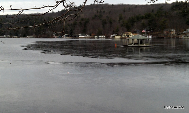 small steps!!!!
__________________
I Live Here... I am always UPTHESAUKEE !!!! |
|
|
|
|
12-19-2011, 03:56 PM
|
#18 |
|
Senior Member
Join Date: Jul 2002
Location: Alton Bay on the mountain by a lake
Posts: 2,023
Thanks: 563
Thanked 444 Times in 311 Posts
|
Ice melted a lot since I saw it at 8 this morning.

__________________
There is nothing better than living on Alton Mountain & our grand kids visits.
|
|
|
|
|
12-19-2011, 04:25 PM
|
#19 |
|
Senior Member

Join Date: Jul 2009
Location: Hooksett,NH
Posts: 84
Thanks: 13
Thanked 33 Times in 20 Posts
|
Does anybody know the water temp?
|
|
|
|
|
12-19-2011, 06:31 PM
|
#21 |
|
Senior Member
Join Date: Jul 2009
Location: Hooksett,NH
Posts: 84
Thanks: 13
Thanked 33 Times in 20 Posts
|
Thank you.
|
|
|
|
|
12-20-2011, 05:37 PM
|
#22 |
|
Senior Member
Join Date: Mar 2011
Posts: 157
Thanks: 1
Thanked 24 Times in 20 Posts
|
I saw a sheen of ice on the Wentworth webcam in early morning yesterday. I fear real winter will never come, what a horrible thought!
|
|
|
|
|
12-20-2011, 05:46 PM
|
#23 |
|
Deceased Member

Join Date: Jul 2006
Location: Gilford, NH
Posts: 2,311
Thanks: 1,070
Thanked 2,054 Times in 497 Posts
|
... is completely iced over. Drove by it today on my way to the Gilford recycle station.
Wonder if it's the same as Ice Out. "They" (whoever They are) say that Lilly Pond goes Ice Out 2 weeks before Winni, maybe it goes "Ice In" 2 weeks before?
__________________
"Before you criticize someone, walk a mile in his shoes. That way, if he gets angry he'll be a mile away and barefoot!" unknown |
|
|
|
|
12-21-2011, 08:18 AM
|
#24 |
|
Senior Member
Join Date: May 2006
Location: Clayton,NC / Sanbornton,NH
Posts: 611
Thanks: 126
Thanked 137 Times in 75 Posts
|
The 10 day outlook on weather.com shows lows in the 20's. That is not ideal for ice making. I hope we don't have a repeat of 2006 when the derby was delayed and there were soft spots all over the place.
|
|
|
|
|
12-21-2011, 11:44 AM
|
#25 |
|
Senior Member
Join Date: Feb 2007
Location: Meredith
Posts: 730
Thanks: 25
Thanked 109 Times in 70 Posts
|
The thickest ice I saw on my way to work this morning was on I93 from Tilton to Manchester. Jeesh.....thanks for the heads up weather forecasters. The scene around the Hooksett tolls was down right apocalyptic.
And I think Winni is going to take a heck of a lot longer than 2 weeks to ice in. This is a bad weather pattern if you enjoy snow and lake ice. |
|
|
|
|
12-21-2011, 12:10 PM
|
#26 |
|
Senior Member

Join Date: Feb 2006
Location: Salem, MA & Meredith, NH
Posts: 116
Thanks: 3
Thanked 24 Times in 7 Posts
|
Has there been a year that the lake hasnt frozen over ?
__________________
JoAnn Frustration is trying to find my glasses without my glasses. 
|
|
|
|
|
12-21-2011, 12:31 PM
|
#27 | |
|
Senior Member
Join Date: May 2006
Location: Clayton,NC / Sanbornton,NH
Posts: 611
Thanks: 126
Thanked 137 Times in 75 Posts
|
Quote:
I know it's still fall, but the bays should be locked up with ice by now right? (even if it's just a couple of inches) Alton bay seems to be the only one holding any ice and Moultonboro bay seems like it's trying hard. My knowledge is only based on what I can see from the cameras. |
|
|
|
|
|
12-21-2011, 04:13 PM
|
#28 |
|
Senior Member
Join Date: Feb 2003
Location: Moultonboro, NH
Posts: 1,692
Blog Entries: 1
Thanks: 356
Thanked 646 Times in 294 Posts
|
It was surprising to see some of Moultonborough Bay frozen this morning. It had frozen about half-way across over the weekend, but blew out in Monday's winds. Tuesday AM, it was frozen half-way again with a light coat of snow on it. Now, the rains have come and it is looking very thin and gray. It will probably not last till tomorrow.
__________________
-lg |
|
|
|
|
12-22-2011, 09:49 AM
|
#29 |
|
Senior Member
Join Date: Apr 2004
Location: phoenix and moultonboro
Posts: 1,592
Thanks: 65
Thanked 288 Times in 204 Posts
|
lake temp at 40 still two weeks behind last year
__________________
it's tough to make predictions specially about the future |
|
|
|
|
12-22-2011, 01:39 PM
|
#30 |
|
Senior Member
Join Date: Mar 2003
Location: Merrymeeting Lake, New Durham
Posts: 2,228
Thanks: 304
Thanked 799 Times in 368 Posts
|
The water temp is pretty much where it was in December of 2006, a year when many also worried there would be no ice-in. The lake was still mostly open in late January.
But it got very cold in late January, and February, and by the end of January, there were reports of 10" of ice. It can change quickly. It is New England, after all. http://www.winnipesaukee.com/forums/...ghlight=iceout |
|
|
|
| The Following User Says Thank You to Merrymeeting For This Useful Post: | ||
HomeWood (12-22-2011) | ||
|
12-22-2011, 03:17 PM
|
#31 |
|
Senior Member
|
And, this website reports today's Weirs Beach air temp at 1:33-pm to be 48-degrees......now that's pretty warm for December 22!
__________________
.... Banned for life from local thrift store!
|
|
|
|
|
12-22-2011, 05:12 PM
|
#32 | |
|
Senior Member
Join Date: Apr 2008
Location: Tolland CT
Posts: 194
Thanks: 20
Thanked 31 Times in 25 Posts
|
Quote:
|
|
|
|
|
|
12-23-2011, 02:17 PM
|
#33 | |
|
Senior Member

Join Date: Dec 2006
Posts: 534
Thanks: 19
Thanked 134 Times in 61 Posts
|
Quote:
The ice-out history can be found here. |
|
|
|
|
|
12-25-2011, 04:00 PM
|
#34 |
|
Senior Member
Join Date: Dec 2006
Posts: 534
Thanks: 19
Thanked 134 Times in 61 Posts
|
I guess we can declare "ice-in" this morning (Dec 25). The Mt Washington can't make it down the bay today without cutting through a lot of ice. It moved in quickly this morning, and there is a thin sheet of ice at least 1.5 miles long.
|
|
|
|
|
12-26-2011, 10:16 AM
|
#35 |
|
Senior Member

Join Date: Jul 2004
Location: pine island of course!
Posts: 411
Thanks: 261
Thanked 251 Times in 115 Posts
|
we went out to the island yesterday and just a little ice around the mainland dock... it was a beautiful day for a ride in the alumacraft... but the 'wind chill' was freezing when we got any speed up!
we didn't see any (other fools) out on the water hoping for ice -PIG |
|
|
|
|
12-26-2011, 06:08 PM
|
#36 |
|
Senior Member
Join Date: Mar 2003
Location: Merrymeeting Lake, New Durham
Posts: 2,228
Thanks: 304
Thanked 799 Times in 368 Posts
|
With temps remaining in the 40's through the night and heavy wind and rain, We should see much of the skim ice in the protected coves and bays disappear tomorrow night.
But then the next night will be in the low teens, and it will stay below freezing for 24+ hours, so much of it will probably reform. |
|
|
|
|
12-26-2011, 11:12 PM
|
#37 |
|
Senior Member
Join Date: Jan 2003
Location: Alton Bay
Posts: 5,616
Blog Entries: 2
Thanks: 2,483
Thanked 1,988 Times in 1,088 Posts
|
On the way to the dump, errrr landfill, errrrr Transfer Station (ah, politically correct at last
 ), we noticed the ice in the bay was out past Sandy Point. This too will probably change over the next day or so, and then start to reform Thurs. ), we noticed the ice in the bay was out past Sandy Point. This too will probably change over the next day or so, and then start to reform Thurs.
__________________
I Live Here... I am always UPTHESAUKEE !!!! |
|
|
|
|
12-27-2011, 02:14 PM
|
#38 |
|
Senior Member
Join Date: Feb 2008
Location: Gilford, NH / Welch Island
Posts: 6,531
Thanks: 2,454
Thanked 5,465 Times in 2,142 Posts
|
If you look at this thread; http://www.winnipesaukee.com/forums/...ad.php?t=11360 it looks like the broads finally froze right around January 14th last year. Based on this and the 10 day forecast we will be at least two weeks or more later this year.
Thoughts or predictions?? Dan |
|
|
|
|
12-27-2011, 03:13 PM
|
#39 |
|
Senior Member

Join Date: Apr 2004
Location: North Shore, MA
Posts: 1,358
Thanks: 996
Thanked 314 Times in 164 Posts
|
I look at long range weather models as a hobby. They are not always correct, but they do show a trend. Within the last week, two of these long range models have started to show that cold weather, below normal cold weather that is, is coming.
These two models are predicting each of the next three months of 2012 will be below normal temperature-wise in our part of the world. Since it appears the first week or so of January will be near or very slightly above normal, this tells me that it is possible the colder than normal weather will get going soon after the first week in January. If this happens, it could "rescue" the winter activities on the lake. However, we are well behind where we should be this time of the year and as we get into late January, the sun angle gets higher and that starts impacting ice growth, especially if there is no snow on the ice to reflect back the suns rays. Bottom line is, IF these two long range models are correct, we could still have a reasonable winter. However, if they do not have it right and the warm trend of the last six months continues, we will remember this winter as one with poor, unsafe ice conditions. I only have been looking at temperatures, not the more complicated view on precipitation, so I am not saying these models are predicting big snow storms. They might or might not be doing this, I have not looked at this that deeply. We need to get it cold first. I share this only to say there is a possible light at the end of the tunnel. Let's hope it is not another train! R2B |
|
|
|
|
12-27-2011, 03:23 PM
|
#40 |
|
Senior Member
Join Date: May 2006
Location: Clayton,NC / Sanbornton,NH
Posts: 611
Thanks: 126
Thanked 137 Times in 75 Posts
|
As of now, weather.com (TWC) shows some pretty cold temps for the next 10days. The predicted 5* low will help give the ice a jump.
|
|
|
|
|
12-30-2011, 10:16 PM
|
#41 |
|
Senior Member
Join Date: Jul 2009
Location: Hooksett,NH
Posts: 84
Thanks: 13
Thanked 33 Times in 20 Posts
|
There was people on lake pemingewasset today
|
|
|
|
|
12-30-2011, 11:19 PM
|
#42 |
|
Senior Member
Join Date: Mar 2009
Location: Meredith / Manchester
Posts: 373
Thanks: 87
Thanked 84 Times in 57 Posts
|
Wmur stated today that this could be a year that Winni does not completely freeze over. Let's forget about ice inane just concentrate on ice out, ha ha ha.

|
|
|
|
|
01-04-2012, 10:32 AM
|
#43 |
|
Senior Member

Join Date: Apr 2007
Location: Maynard, MA & Paugus Bay
Posts: 2,616
Thanks: 755
Thanked 369 Times in 277 Posts
|
How does the lake look this morning?
__________________
Capt. of the "No Worries" |
|
|
|
|
01-04-2012, 11:45 AM
|
#44 | |
|
Senior Member
Join Date: Apr 2008
Location: Moultonborough
Posts: 764
Thanks: 4
Thanked 260 Times in 172 Posts
|
Quote:
Well, actually, with the sun out so brightly, the sky so blue, and no snow around as I look out over the water, it looks like a nice fall day. The wind isn't as strong as it had been, so there are no whitecaps between Long Island and the Neck. I do notice that in close to shore, for 50 ft or so out, the quieter water has allowed some ice to reform overnight. Further out, where the breeze is cooling the water rapidly, it also is turning over the surface and mixing it with slightly less cold water below it and delaying the freezing. |
|
|
|
|
|
01-04-2012, 12:13 PM
|
#45 |
|
Senior Member
Join Date: Feb 2008
Location: Gilford, NH / Welch Island
Posts: 6,531
Thanks: 2,454
Thanked 5,465 Times in 2,142 Posts
|
I have given up on seeing any kind of decent ice fishing or winter sport season on Winni this year. With the 10 day weather forecast predicting above freezing temps during the day and mid forties on Saturday, the chance of the broads freezing over this year are slim.
 Oh well, looks like the camp will open just that much earlier this year! Dan |
|
|
|
| The Following User Says Thank You to ishoot308 For This Useful Post: | ||
codeman671 (01-04-2012) | ||
|
01-04-2012, 02:32 PM
|
#46 |
|
Senior Member
Join Date: May 2006
Location: Clayton,NC / Sanbornton,NH
Posts: 611
Thanks: 126
Thanked 137 Times in 75 Posts
|
I'll settle for bare ice at this point and I'll leave the sled in NC. I just want to be able to fish and ride the atv's to my favorite spots.
If anybody is up flying around, I'd like to see some pics of the lake from the sky. The webcams give me a good idea of what parts are freezing, but it's only a handful of areas. |
|
|
|
|
01-04-2012, 04:23 PM
|
#47 | |
|
Senior Member

Join Date: Jul 2002
Location: Pennsyltuckey, Tuftonboro, Moultonborough
Posts: 1,510
Thanks: 387
Thanked 234 Times in 128 Posts
|
Quote:
__________________
"When I die, please don't let my wife sell my dive gear for what I told her I paid for it." |
|
|
|
|
| The Following User Says Thank You to Grant For This Useful Post: | ||
AC2717 (01-04-2012) | ||
|
01-04-2012, 04:49 PM
|
#48 |
|
Senior Member
Join Date: Apr 2004
Location: North Shore, MA
Posts: 1,358
Thanks: 996
Thanked 314 Times in 164 Posts
|
Don't give up yet! There will be less wind over the next few nights and the lake is cold enough to freeze, as CLA has pointed out. We could see the bays locking up by this Friday night, some sooner.
Yes, there will be one warm day Saturday, but by the following Thursday, it will be very cold. Winter is coming and it looks to be below normal cold for the period Jan 11th onward for a few weeks, perhaps longer. I expect that in the end, Jan and Feb will be below normal temperature wise. Time will tell, but I am fairly confident with this. Once it gets cold, the snow will follow. R2B Last edited by Resident 2B; 01-04-2012 at 05:22 PM. |
|
|
|
|
01-04-2012, 04:55 PM
|
#49 |
|
Senior Member
Join Date: Mar 2003
Location: Merrymeeting Lake, New Durham
Posts: 2,228
Thanks: 304
Thanked 799 Times in 368 Posts
|
See earlier reference to 2006... most were giving up that year too.
The lake was frozen solid by late January. |
|
|
|
|
01-04-2012, 05:26 PM
|
#50 |
|
Senior Member
Join Date: Apr 2004
Location: North Shore, MA
Posts: 1,358
Thanks: 996
Thanked 314 Times in 164 Posts
|
Check out the Weirs Cam time-lapse video for today. The wind goes down and the bay skims over. Wow!!!
R2B |
|
|
|
|
01-04-2012, 08:31 PM
|
#51 |
|
Junior Member
Join Date: May 2009
Posts: 16
Thanks: 1
Thanked 3 Times in 2 Posts
|
Time for some skating
|
|
|
|
|
01-05-2012, 09:29 AM
|
#52 |
|
Senior Member
Join Date: Apr 2004
Posts: 753
Thanks: 59
Thanked 271 Times in 129 Posts
|
C'mon!! My bet is we'll have plenty of ice by 28th, maybe a little earlier. It's been a little slow in coming this year, but the weather patterns are beginning to trend more towards real winter. Ice is forming in the bays and beyond. Patience....
|
|
|
|
|
01-05-2012, 09:39 AM
|
#53 |
|
Senior Member
Join Date: Mar 2003
Location: Merrymeeting Lake, New Durham
Posts: 2,228
Thanks: 304
Thanked 799 Times in 368 Posts
|
The water temp has dropped the past few days and is sitting in the low 30's. It won't take much. A few days of no wind and temps below 32 and it will skim over.
|
|
|
|
|
01-05-2012, 09:55 AM
|
#54 | |
|
Senior Member
Join Date: Feb 2008
Location: Gilford, NH / Welch Island
Posts: 6,531
Thanks: 2,454
Thanked 5,465 Times in 2,142 Posts
|
Quote:
I'm saying that I am giving up to throw Mother Nature off. Old Ma Nature knows how much I enjoy my winter time activities on the big lake and she is trying to mess with my head with all this warm weather! She likes doing stuff like that, she can be bitchy at times! I figure if I say I have given up it will throw her off just enough to get some cold weather here and get the ice locked up.  I'm feeling much better now! Happy New Year! Dan |
|
|
|
|
|
01-05-2012, 10:14 AM
|
#55 |
|
Senior Member

Join Date: Aug 2004
Location: Moultonborough & CT
Posts: 2,550
Thanks: 1,071
Thanked 672 Times in 369 Posts
|
|
|
|
|
|
01-05-2012, 11:10 AM
|
#56 |
|
Senior Member

Join Date: Jan 2011
Location: Wolfeboro
Posts: 868
Thanks: 584
Thanked 540 Times in 210 Posts
|
Just want to report that the water in front of my rental house has frozen in motion. For the past two months I've been watching the winds kick up this little bay and this morning, all of a sudden it was frozen in place. Just like that. It's a very thin veneer of ice because I can see the water undulating beneath and moving this delicate frozen surface.
Fascinating. |
|
|
|
|
01-05-2012, 11:12 AM
|
#57 |
|
Senior Member
Join Date: Apr 2008
Location: Moultonborough
Posts: 764
Thanks: 4
Thanked 260 Times in 172 Posts
|
This am the area between Long Island and the Neck is wall to wall ice.
|
|
|
|
|
01-05-2012, 11:27 AM
|
#58 |
|
Senior Member
Join Date: May 2006
Location: Clayton,NC / Sanbornton,NH
Posts: 611
Thanks: 126
Thanked 137 Times in 75 Posts
|
Somebody on iceshanty.com states there is 4" of ice in Alton bay. Great start!
|
|
|
|
|
01-05-2012, 11:46 AM
|
#59 |
|
Senior Member

Join Date: Jan 2006
Posts: 6,941
Thanks: 795
Thanked 1,493 Times in 1,040 Posts
|
Most of Winter Harbor has a very thin delicate layer this morning.
|
|
|
|
|
01-05-2012, 12:15 PM
|
#60 | |
|
Senior Member
Join Date: Apr 2004
Location: North Shore, MA
Posts: 1,358
Thanks: 996
Thanked 314 Times in 164 Posts
|
Quote:
Dan, Great strategy! Happy New Year to you! Enjoy whatever winter we get. R2B |
|
|
|
|
|
01-06-2012, 07:57 AM
|
#61 |
|
Senior Member
Join Date: Apr 2006
Location: Alton, NH
Posts: 722
Thanks: 337
Thanked 280 Times in 123 Posts
|
First house on yesterday with two guys chasing flags. Wow and only 4-5" of ice. I am anxious but not that anxious, one good warm rain could make a huge difference.
__________________
Waking up in the morning is the greatest, everything after that is a bonus
|
|
|
|
|
01-06-2012, 08:46 AM
|
#62 |
|
Member
Join Date: Feb 2010
Posts: 23
Thanks: 0
Thanked 8 Times in 4 Posts
|
We have been ice skating on the north end of the big lake since Christmas Day .
|
|
|
|
|
01-06-2012, 09:49 AM
|
#63 | |
|
Senior Member
Join Date: Feb 2007
Location: Meredith
Posts: 730
Thanks: 25
Thanked 109 Times in 70 Posts
|
Quote:
|
|
|
|
|
|
01-06-2012, 10:02 AM
|
#64 | |
|
Senior Member

Join Date: Apr 2004
Location: Belmont NH but prefer Jackman Maine
Posts: 1,857
Thanks: 491
Thanked 410 Times in 251 Posts
|
Quote:
__________________
"better to have a short life that is full of what you like doing, then a long life spent in a miserable way.."
|
|
|
|
|
|
01-06-2012, 12:07 PM
|
#65 |
|
Senior Member
Join Date: Feb 2003
Location: Moultonboro, NH
Posts: 1,692
Blog Entries: 1
Thanks: 356
Thanked 646 Times in 294 Posts
|
North of Moultonborough Bay (think light marker 14) it is all but frozen over now. We had a heavy dusting of snow this morning, so the holes in the ice are easily visible. Near rocks and in strange (probably spring fed) places, there are still small open spots, but for the most part, the ice is thick enough to gingerly walk on. Two inches is enough to keep the winds from removing the ice (for the fifth time this year) but not thick enough for anything more than a cautious foray near the shoreline or the local minks.
__________________
-lg |
|
|
|
|
01-06-2012, 08:28 PM
|
#66 |
|
Senior Member
Join Date: Mar 2003
Location: Merrymeeting Lake, New Durham
Posts: 2,228
Thanks: 304
Thanked 799 Times in 368 Posts
|
My area of Merrymeeting was wide open as of Monday. Returned today to find somewhat thick ice several hundred yards out. Not enough to walk on, but more than a skim. But by afternoon it already seemed to be retreating as the temp came up.
What surprised me more was my drive to Alton Bay. At about 4PM this afternoon, there were 4-5 ice fishermen out on the Bay. Several were well beyond the bandstand, out in the middle Given the areas of open water showing in multiple areas, not sure I'd trust it. There was also 1 bob house already out, almost out to the bandstand, and beyond (north of) it. |
|
|
|
|
01-07-2012, 12:37 PM
|
#67 |
|
Senior Member
Join Date: Jul 2002
Location: Alton Bay on the mountain by a lake
Posts: 2,023
Thanks: 563
Thanked 444 Times in 311 Posts
|

__________________
There is nothing better than living on Alton Mountain & our grand kids visits.
|
|
|
|
|
01-07-2012, 02:30 PM
|
#68 |
|
Senior Member
Join Date: Jul 2009
Location: Hooksett,NH
Posts: 84
Thanks: 13
Thanked 33 Times in 20 Posts
|
Any body know how thick the ice is? Also any news on 19 mile bay?
|
|
|
|
|
01-07-2012, 04:26 PM
|
#69 | |
|
Senior Member
Join Date: May 2006
Location: Clayton,NC / Sanbornton,NH
Posts: 611
Thanks: 126
Thanked 137 Times in 75 Posts
|
Quote:
|
|
|
|
|
|
01-10-2012, 11:31 AM
|
#70 |
|
Senior Member
Join Date: Mar 2003
Location: Merrymeeting Lake, New Durham
Posts: 2,228
Thanks: 304
Thanked 799 Times in 368 Posts
|
I was gone from the area since Saturday, just returning today. It's interesting what has happened to the ice.
The Merrymeeting River is now almost completely closed in. It was still mostly open when we left on Saturday. So ice formation has continued. (For those who may not know, the Merrymeeting River flows into Alton Bay) But at the same time, most of the ice that had formed in some of the coves on the lake has disappeared. In any case, all the water bodies seem to be right at the tipping point needed to freeze. All it's going to take is extended, below 32 degree temps, something that appears to be coming next week. |
|
|
|
|
01-10-2012, 12:28 PM
|
#71 |
|
Senior Member
Join Date: Feb 2003
Location: Moultonboro, NH
Posts: 1,692
Blog Entries: 1
Thanks: 356
Thanked 646 Times in 294 Posts
|
Much of the northeast quadrant of the lake is 95% frozen, with lots of it 4-5" thick. Today, it has been singing. Very cool sounds and a sign that it is getting close to being safe. If we get the snow on Thursday as advertised, XC'ing on the lake should be very nice this weekend.
__________________
-lg |
|
|
|
|
01-10-2012, 02:59 PM
|
#72 |
|
Senior Member
Join Date: Apr 2007
Location: Maynard, MA & Paugus Bay
Posts: 2,616
Thanks: 755
Thanked 369 Times in 277 Posts
|
THE WEIRS CAM HAS ICE THE WEIRS CAM HAS ICE
wow, i am getting excited here folks seriously
__________________
Capt. of the "No Worries" |
|
|
|
|
01-10-2012, 07:12 PM
|
#73 |
|
Senior Member
Join Date: May 2006
Location: Clayton,NC / Sanbornton,NH
Posts: 611
Thanks: 126
Thanked 137 Times in 75 Posts
|
Great reports. Thanks!
|
|
|
|
|
01-10-2012, 07:52 PM
|
#74 | |
|
Senior Member
Join Date: Aug 2006
Location: Moultonborough, NH
Posts: 484
Thanks: 89
Thanked 138 Times in 72 Posts
|
Quote:
|
|
|
|
|
|
01-10-2012, 08:08 PM
|
#75 | |
|
Senior Member
Join Date: Apr 2004
Location: North Shore, MA
Posts: 1,358
Thanks: 996
Thanked 314 Times in 164 Posts
|
Quote:
I do not think the entire northeast quadrant is frozen right now, but there is ice up in that area. R2B |
|
|
|
|
|
01-11-2012, 07:30 AM
|
#76 | |
|
Senior Member
Join Date: Jan 2005
Posts: 2,129
Thanks: 1,358
Thanked 564 Times in 291 Posts
|
Quote:
|
|
|
|
|
|
01-11-2012, 09:19 AM
|
#77 | |
|
Senior Member
Join Date: Feb 2003
Location: Moultonboro, NH
Posts: 1,692
Blog Entries: 1
Thanks: 356
Thanked 646 Times in 294 Posts
|
Quote:
__________________
-lg |
|
|
|
|
|
01-11-2012, 10:28 AM
|
#78 |
|
Senior Member
Join Date: Mar 2003
Location: Merrymeeting Lake, New Durham
Posts: 2,228
Thanks: 304
Thanked 799 Times in 368 Posts
|
I posted a few photos taken of Alton Bay yesterday.
Still shaking my head after watching the guy walking near the open water near the town beach!  better view here http://www.winnipesaukee.com/photopo...hp?photo=18288 Last edited by Merrymeeting; 01-11-2012 at 11:11 AM. |
|
|
|
|
01-11-2012, 10:39 AM
|
#79 | |
|
Senior Member
Join Date: Aug 2006
Location: Moultonborough, NH
Posts: 484
Thanks: 89
Thanked 138 Times in 72 Posts
|
Quote:
Last edited by Irrigation Guy; 01-11-2012 at 06:13 PM. |
|
|
|
|
|
01-11-2012, 05:48 PM
|
#80 |
|
Senior Member

Join Date: Jul 2002
Location: Central MA
Posts: 2,358
Thanks: 18
Thanked 577 Times in 183 Posts
|
In keeping with tradition and philosophy (well mine anyway...) I am declaring this thread the Official Ice-in Thread rather than start a new one. Traditionally I start this thread in late Decemeber when it looks like the water is getting cold enough to freeze. It has been warm and I have been attending to other matters so am too late to start a new thread as this one has so much good info and pictures!
I love it when ice-in pics and discussion are all in one thread for easy reading. (again, just my philosophy, not a demand! )The Ice-In Pageisup at www.rattlesnakecam.com/icein.htm. Here you can watch the lake freeze from many different cams. I think this is the 8th year the page has been live! This year is a new cam.... one that has an incredible view, and is much welcome. Please wander on over and see if you can find it! Thanks to our newest webcam operator!!!! The lake temp reported by the dam operators is 35 degrees. The broads can freeze when this thermometer is at that reading or a little below. We don't really know what the lake temp is out there, this is just historically what has happened over the last several years. Let it ice, let it ice, let it ice....... IG Sorry for being so late this year
__________________
Island Girl ....... Make Lemonade |
|
|
|
| The Following User Says Thank You to Island Girl For This Useful Post: | ||
Lakegeezer (01-11-2012) | ||
|
01-11-2012, 07:30 PM
|
#81 | |
|
Senior Member
Join Date: Mar 2003
Location: Merrymeeting Lake, New Durham
Posts: 2,228
Thanks: 304
Thanked 799 Times in 368 Posts
|
Quote:
|
|
|
|
|
|
01-11-2012, 10:30 PM
|
#82 |
|
Senior Member

Join Date: Apr 2004
Location: Moultonboro, NH
Posts: 2,953
Thanks: 484
Thanked 703 Times in 393 Posts
|
Measured 8 inches of ice Blackey's cove, about 1000 feet from shore......
|
|
|
|
|
01-12-2012, 08:36 AM
|
#83 | |
|
Senior Member
Join Date: Apr 2004
Location: Eastern MA & Frye Island/Sebago Lake, Maine
Posts: 958
Thanks: 257
Thanked 351 Times in 158 Posts
|
Quote:
That was EASY...Mr. Hughes has a cam at Minge Cove now??!!!
__________________
" Live for today because yesterday is gone and tomorrow may never come" |
|
|
|
|
|
01-12-2012, 11:33 AM
|
#84 | |
|
Junior Member
Join Date: Jan 2012
Location: Dover, NH
Posts: 6
Thanks: 2
Thanked 0 Times in 0 Posts
|
Quote:
|
|
|
|
|
|
01-12-2012, 01:47 PM
|
#85 | |
|
Senior Member
Join Date: Apr 2004
Location: Moultonboro, NH
Posts: 2,953
Thanks: 484
Thanked 703 Times in 393 Posts
|
Quote:
Center harbor was beginning to freeze, with I would say about 75% frozen, but it didn't look safe to me. |
|
|
|
|
| The Following User Says Thank You to ITD For This Useful Post: | ||
JPerron2004 (01-12-2012) | ||
|
01-12-2012, 05:24 PM
|
#86 | |
|
Junior Member
Join Date: Jan 2012
Location: Dover, NH
Posts: 6
Thanks: 2
Thanked 0 Times in 0 Posts
|
Quote:
|
|
|
|
|
|
01-12-2012, 05:49 PM
|
#87 | |
|
Senior Member
Join Date: Apr 2004
Location: Moultonboro, NH
Posts: 2,953
Thanks: 484
Thanked 703 Times in 393 Posts
|
Quote:
Welcome to the Forum!! |
|
|
|
|
|
01-13-2012, 03:50 PM
|
#88 |
|
Senior Member
Join Date: Mar 2009
Posts: 75
Thanks: 3
Thanked 46 Times in 10 Posts
|
Does anyone know when the Alton winter festival is scheduled this year? Praying for cold !
|
|
|
|
|
01-13-2012, 04:03 PM
|
#89 |
|
Senior Member
Join Date: Jan 2003
Location: Alton Bay
Posts: 5,616
Blog Entries: 2
Thanks: 2,483
Thanked 1,988 Times in 1,088 Posts
|
Alton Winter festival or carnival will be held on Sunday Feb 19.
__________________
I Live Here... I am always UPTHESAUKEE !!!! |
|
|
|
|
01-13-2012, 05:26 PM
|
#90 |
|
Senior Member
Join Date: Mar 2003
Location: Merrymeeting Lake, New Durham
Posts: 2,228
Thanks: 304
Thanked 799 Times in 368 Posts
|
Using reverse logic, technically we already have Ice-In.
If Ice-out is when the Mount can navigate to all it's ports without hitting ice, then I guess Ice-In is once it can't get to it's ports without hitting ice. Given Alton and Center Harbor have ice.... 
|
|
|
|
|
01-13-2012, 05:49 PM
|
#91 |
|
Senior Member
Join Date: Dec 2006
Posts: 121
Thanks: 0
Thanked 3 Times in 3 Posts
|
Question for you weather pros. I've been following the weather out there for the past couple weeks due to the warm weather. I'm a bit concerned about ice for our trip out next month. I typically look at Weather.com but today looked at Accuweather.com and noticed there is a fairly substantial difference in the forcasted temps from one site to the other. For example for tomorrow weather.com has H16 & L-5 whereas accuweather.com has H22 & L1.
So my question is (especially for those who live there year round) which site do you feel more accurately predicts the weather/temps? FYI our place is in Meredith so that is the location I always search. Thanks.
|
|
|
|
|
01-13-2012, 09:17 PM
|
#92 | |
|
Senior Member
Join Date: Apr 2004
Location: Eastern MA & Frye Island/Sebago Lake, Maine
Posts: 958
Thanks: 257
Thanked 351 Times in 158 Posts
|
Quote:
http://forecast.weather.gov/MapClick...2=-71.5043&e=1
__________________
" Live for today because yesterday is gone and tomorrow may never come" |
|
|
|
|
|
01-14-2012, 08:21 AM
|
#93 |
|
Senior Member
Join Date: Mar 2011
Posts: 157
Thanks: 1
Thanked 24 Times in 20 Posts
|
I really enjoy watching the live stream in Alton. About 7:15 AM I watched about a dozen people crossing the ice to fish. Enjoy. Any other places on the Lake that firm?
|
|
|
|
|
01-14-2012, 10:42 PM
|
#94 |
|
Senior Member
Join Date: Mar 2009
Location: Meredith / Manchester
Posts: 373
Thanks: 87
Thanked 84 Times in 57 Posts
|
4 degrees in Merecith tonight and NO ice on the bay yet. Yay!!!!!!!!! Ready to put the boat in.
|
|
|
|
|
01-14-2012, 10:47 PM
|
#95 | |
|
Senior Member
Join Date: Apr 2004
Location: North Shore, MA
Posts: 1,358
Thanks: 996
Thanked 314 Times in 164 Posts
|
Quote:
The bay will freeze tomorrow night. Let's hope it thickens up before the wind gets going again. R2B Last edited by Resident 2B; 01-15-2012 at 01:43 AM. |
|
|
|
|
|
01-15-2012, 01:37 AM
|
#96 |
|
Senior Member
Join Date: Jul 2002
Location: Central MA
Posts: 2,358
Thanks: 18
Thanked 577 Times in 183 Posts
|
I agree with R2B. We will see the lake skimmed over Monday when we wake up!
__________________
Island Girl ....... Make Lemonade |
|
|
|
|
01-15-2012, 09:46 AM
|
#97 | |
|
Senior Member
Join Date: Mar 2009
Location: Meredith / Manchester
Posts: 373
Thanks: 87
Thanked 84 Times in 57 Posts
|
Quote:
Noooooooo!!!!!!!!!!!!!!!!!
|
|
|
|
|
|
01-15-2012, 06:49 PM
|
#98 | |
|
Senior Member
Join Date: Apr 2004
Location: Eastern MA & Frye Island/Sebago Lake, Maine
Posts: 958
Thanks: 257
Thanked 351 Times in 158 Posts
|
Quote:
__________________
" Live for today because yesterday is gone and tomorrow may never come" |
|
|
|
|
|
01-15-2012, 07:10 PM
|
#99 | |
|
Senior Member
Join Date: Apr 2004
Location: North Shore, MA
Posts: 1,358
Thanks: 996
Thanked 314 Times in 164 Posts
|
Quote:
High confidence with this. R2B |
|
|
|
|
|
01-15-2012, 07:18 PM
|
#100 |
|
Senior Member
Join Date: Mar 2003
Location: Merrymeeting Lake, New Durham
Posts: 2,228
Thanks: 304
Thanked 799 Times in 368 Posts
|
It also expect that we will see a lot of areas freeze over the next few days if the wind dies. It's certainly cold enough.
But as CLA pointed out in his "double-digit dates" note, the solar gain is already getting stronger. I was amazed this morning when looking outside. We have a porch roof on our house that can be seen from an upstairs window. The area under the roof is unheated. The outside thermometer reading was 4 degrees. Despite all this, the black-shingled roof, facing the mid-morning sun, was melting the snow on the roof at an amazing pace. The water was just pouring off the roof. The weather, as always, remains fascinating. |
|
|
|
|
| Bookmarks |
|
|


 Linear Mode

