

|
|
|
|
|
|||||||
| Home | Forums | Gallery | Webcams | Blogs | YouTube Channel | Classifieds | Calendar | Register | FAQ | Donate | Members List | Today's Posts | Search |
 |
|
|
Thread Tools | Display Modes |
 03-11-2010, 11:15 AM
|
#1 |
|
Senior Member

Join Date: May 2006
Location: Long Island, not that one, the one on Winnipesaukee
Posts: 2,835
Thanks: 1,018
Thanked 884 Times in 517 Posts
|
So, as many of us are I am anxiously awaiting Ice-Out this year. Which unless we get a major cold snap of biblical proportions is probably going to happen very early this year. However I am very concerned about what this year could bring for lake levels. Normally there is lots of spring run off from melting snow, and the draw down of the big lake takes all that into consideration. The major melt off is not going to be what it normally is because haha there just isn't that much snow. Hopefully we will get some rain, which coupled with smart dam management will help fill up the lake. However I fear this years boating season could be hampered severely by low lake levels. As we all know, many boat ramps become unusable. As well many lake front home owners don't have enough water at there docks etc. to deal with a low lake situation all summer.
Luckily I have an extra dock section or two so if it got really bad I could always extend my dock. Desperate time call for desperate measures (please lets not argue the legalities of this we all know what they are). But I know most people can not, additionally if the low water starts causing problems at ramps it ruins things for day boaters, and some ramps have sharp drop offs... Well hopefully I have given everyone something to think about and comment on....... A bad winter may lead to a not so great summer......
__________________
Life is about how much time you can spend relaxing... I do it on an island that isn't really an island..... |

|

|
|
03-11-2010, 12:11 PM
|
#2 |
|
Senior Member

Join Date: Oct 2005
Location: Pine (Alton) Mountain
Posts: 138
Thanks: 39
Thanked 33 Times in 20 Posts
|
01234567890
Last edited by LakeSnake; 06-15-2010 at 12:05 PM. |
|
|
|
|
03-11-2010, 04:15 PM
|
#3 | |
|
Senior Member
Join Date: May 2006
Location: Long Island, not that one, the one on Winnipesaukee
Posts: 2,835
Thanks: 1,018
Thanked 884 Times in 517 Posts
|
Quote:
__________________
Life is about how much time you can spend relaxing... I do it on an island that isn't really an island..... |
|
|
|
|
|
03-12-2010, 07:58 AM
|
#4 | |
|
Senior Member

Join Date: Apr 2004
Location: Bow
Posts: 1,874
Thanks: 521
Thanked 308 Times in 162 Posts
|
Quote:
__________________
Getting ready for winter! |
|
|
|
|
|
03-15-2010, 09:34 AM
|
#5 |
|
Senior Member

Join Date: Mar 2004
Location: Piscataway, NJ
Posts: 1,030
Thanks: 2
Thanked 46 Times in 24 Posts
|
Looking at the DOWNINGSLANDING CAM the lake seems to be up. The old gas dock is just above the surface.
|
|
|
|
| Sponsored Links |
|
|
|
03-15-2010, 10:14 AM
|
#6 | |
|
Senior Member
Join Date: May 2006
Location: Long Island, not that one, the one on Winnipesaukee
Posts: 2,835
Thanks: 1,018
Thanked 884 Times in 517 Posts
|
Quote:
I believe Chip does indeed have the piece of the equation that we need to allow to unfold some. I believe the amount of rain fall in April, and May could indeed have a huge influence either way on future of the boating season and the lake level for the year. The dam operators only have so much control.... when water is needed down stream they have no choice but to allow water to flow... I have been looking at more then just lake level data, I have been looking at river flows etc. believe me this winter and its lack of snow has a ripple effect.
__________________
Life is about how much time you can spend relaxing... I do it on an island that isn't really an island..... |
|
|
|
|
|
03-15-2010, 10:17 AM
|
#7 |
|
Senior Member

Join Date: Feb 2009
Location: Laconia NH
Posts: 181
Thanks: 8
Thanked 10 Times in 9 Posts
|
All the rain we got this weekend and the other two rainstorms we had this winter are equal to like 5 or 6 feet of snow, so that translates to 60-72 inches of snow, plus the 50 inches have had of snow, there ya go, it's more moisture than the last two winters. Since the ground is frozen, it all went directly into the lake.
|
|
|
|
|
03-15-2010, 12:20 PM
|
#8 |
|
Senior Member

Join Date: Jan 2005
Location: Nashua,Meredith
Posts: 951
Thanks: 213
Thanked 106 Times in 81 Posts
|
But with all the rain down in the southern part of the state I would think they have to slow the outflow at the dam.
|
|
|
|
|
03-15-2010, 01:39 PM
|
#9 |
|
Senior Member

Join Date: Jul 2002
Location: Central MA
Posts: 2,352
Thanks: 18
Thanked 535 Times in 179 Posts
|
since Friday....
__________________
Island Girl ....... Make Lemonade |
|
|
|
|
03-15-2010, 04:20 PM
|
#10 |
|
Senior Member

Join Date: Jul 2002
Location: North Kingstown RI
Posts: 688
Thanks: 143
Thanked 83 Times in 55 Posts
|
__________________
Gene ~ aka "another RI Swamp Yankee" |
|
|
|
|
03-15-2010, 08:22 PM
|
#11 |
|
Senior Member

Join Date: Jan 2007
Location: Center Harbor
Posts: 1,049
Thanks: 15
Thanked 472 Times in 107 Posts
|
There may be "not much snow" around the lake shores but this has turned into quite a winter for elevations above 1500 feet. Randolph NH had 39 inches of snow in the storm 2 weeks ago, and more since. Wildcat Mountain has had something like 5 feet of snow in the last 2 weeks and another foot from this current storm. Mt. Major is looking very white right now. It's a great time to go skiing!
Sooner or later, that snow is going to melt and run downhill. The lake is now 5 inches below my approximate-full mark. |
|
|
|
|
03-23-2010, 07:31 AM
|
#12 |
|
Senior Member

Join Date: Jul 2002
Location: Massachusetts
Posts: 332
Thanks: 0
Thanked 242 Times in 81 Posts
|
The lake has reached the full mark.
http://www.bizer.com/bztnews.htm#lakelevel |
|
|
|
|
03-23-2010, 08:09 AM
|
#13 |
|
Senior Member
Join Date: Jan 2007
Location: Center Harbor
Posts: 1,049
Thanks: 15
Thanked 472 Times in 107 Posts
|
The weather station has received 0.70 inch of rain today and there is more on the way. The mountains are also getting rain from this, so snowmelt is beginning to occur there. Expect the lake to continue rising.
|
|
|
|
|
03-23-2010, 12:02 PM
|
#14 |
|
Senior Member
Join Date: May 2004
Posts: 230
Thanks: 21
Thanked 14 Times in 8 Posts
|
The lake looks about full..
|
|
|
|
|
03-28-2010, 08:35 AM
|
#15 |
|
Senior Member
Join Date: Feb 2003
Location: Moultonboro, NH
Posts: 1,657
Blog Entries: 1
Thanks: 342
Thanked 618 Times in 278 Posts
|
The water flow at Lakeport dam today is over 1750 cubit feet per second, which is an emergency rate. The lake level is out of control again, at more than a foot above average for April 1. The level is 504.55 which is well above full lake (503.63), near a record high for this time of year (since 1982) and well above the planned limit for anytime during year (504.32). Typical for this time of year is 502.75 to 503.75. We are expecting heavy rain again this week and there is still snow in the higher elevations of the winny watershed. My beach is already eroding. Its a good thing that boat traffic is virtually nil. We could easily hit 505 by the end of the week - which should trigger a no-wake rule until the floods recede.
__________________
-lg |
|
|
|
|
03-28-2010, 09:38 AM
|
#16 |
|
Senior Member
Join Date: Jun 2007
Location: Hudson - NH
Posts: 408
Thanks: 233
Thanked 212 Times in 88 Posts
|
I like the no wake time of the year. You can go out for hours and barely move the fuel needle!
 I believe the last time we had a no wake condition it was posted "No Wake within 600 feet of shore". That was made interesting because many "bonehead" drivers had trouble with 150 ft and they still zipped by us at less than the 150 foot distance. No harm to us but it was wrong. |
|
|
|
|
03-28-2010, 09:57 AM
|
#17 |
|
Senior Member
Join Date: Jan 2005
Location: Nashua,Meredith
Posts: 951
Thanks: 213
Thanked 106 Times in 81 Posts
|
I remember it well.I was sitting talking to marine patrol about it while out in the Broads and there goes Captain Bonehead at about 60mph and the officer just shook his head and went off to educate him on what no wake means. And yes the fuel last quite awhile.
|
|
|
|
|
03-28-2010, 11:04 PM
|
#18 | |
|
Senior Member
Join Date: May 2006
Location: Long Island, not that one, the one on Winnipesaukee
Posts: 2,835
Thanks: 1,018
Thanked 884 Times in 517 Posts
|
Quote:
I have been looking at a lot of the DES watershed data form many of the lakes and streams.... although there has been a significant amount of rain in a very short period of time which has cause many bodies of water to raise quickly. I have seen that all bodies of water have reacted and continue to react very quickly to the dam operations. In short I don't believe we will spend very long with a full lake. As long as we can get a week or two of good warm weather the lake will come right down.
__________________
Life is about how much time you can spend relaxing... I do it on an island that isn't really an island..... |
|
|
|
|
|
03-28-2010, 11:34 PM
|
#19 | |
|
Senior Member

Join Date: Nov 2002
Location: The Lakes, Central NH. and Dallas/Fort Worth TX.
Posts: 3,694
Blog Entries: 3
Thanks: 3,069
Thanked 472 Times in 236 Posts
|
Quote:
I really wouldn't worry to much about it. Terry ____________________________________
__________________
trfour Always Remember, The Best Safety Device In The Boat, or on a PWC Snowmobile etc., Is YOU! Safe sledding tips and much more; http://www.snowmobile.org/snowmobiling-safety.html |
|
|
|
|
|
03-29-2010, 04:09 AM
|
#20 | |
|
Senior Member

Join Date: Jan 2005
Location: Florida (Sebring & Keys), Wolfeboro
Posts: 5,789
Thanks: 2,086
Thanked 742 Times in 532 Posts
|
Quote:
 )... )... I'll get particularly irked.    I'm generally happy to own an acre of "near-to-nature" lakefront property. I'm generally happy to own an acre of "near-to-nature" lakefront property.  However... ") 1) When the lake is over-filled, a great deal of forest duff gets "redistributed" along shallow shorelines. (Once redistributed along the shoreline, some would call this mud—or silt). 2) These become the nutrients that promote algae—the snails that browse on the algae—and thence to the outbreaks of "Duck Itch". 3) With a no-wake rule invoked due to this mis-cue—though still pending—I'd expect that folks living around Lake Winnipesaukee's bays and coves will experience a growth rate increase of milfoil.  4) It's a much-bigger "deal" than having to discipline the speed of over-sized boats—temporarily. IMHO Last edited by ApS; 03-29-2010 at 10:56 AM. Reason: Add "call" |
|
|
|
|
|
03-29-2010, 06:00 AM
|
#21 | |
|
Senior Member
Join Date: Feb 2003
Location: Moultonboro, NH
Posts: 1,657
Blog Entries: 1
Thanks: 342
Thanked 618 Times in 278 Posts
|
Quote:
__________________
-lg |
|
|
|
|
|
03-29-2010, 10:29 AM
|
#22 | |
|
Senior Member
Join Date: May 2006
Location: Long Island, not that one, the one on Winnipesaukee
Posts: 2,835
Thanks: 1,018
Thanked 884 Times in 517 Posts
|
Quote:
__________________
Life is about how much time you can spend relaxing... I do it on an island that isn't really an island..... |
|
|
|
|
|
03-30-2010, 08:50 PM
|
#23 |
|
Senior Member

Join Date: Dec 2006
Posts: 534
Thanks: 19
Thanked 134 Times in 61 Posts
|
Looking at the level for March 30, one thing is obvious -- the lake level has never been this high, this early in the year --- ever! (at least since 1982, when the lake level chart records began). And this doesn't include today's rain.
So, for everyone who's saying "the lake will recede quickly", I hope you're right -- but so far, history shows it will take 1 - 2 months for the lake to drop down to get back to "Full". That puts us at mid-late May, assuming no more real wet periods over that time. Wishful thinking? Or are we facing a different reality, which might involve "no wake" for quite a while? |
|
|
|
|
03-30-2010, 09:07 PM
|
#24 |
|
Senior Member
Join Date: Jul 2002
Location: Central MA
Posts: 2,352
Thanks: 18
Thanked 535 Times in 179 Posts
|
If you want to monitor the lake level and get information about the flow out of the dam at Lakeport you can go to the Lake Watch page on RattlesnakeCam.com. On the right side there are several links. The image below describes three of these that are relevant to the current high lake conditions. Bizer updates his charts when there are rapidly changing conditions, so make sure to visit his site. The other links also have interesting lake information.
Think warm and dry! See bottom of this post for URLs if you cannot click on above links. IG 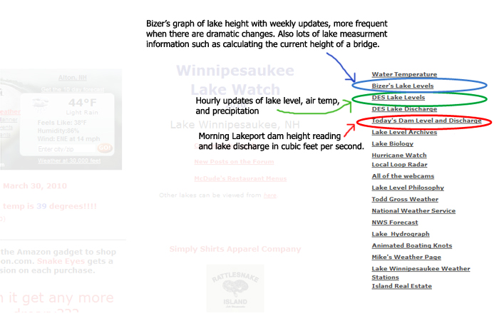 http://www.rattlesnakecam.com/watch.htm http://www.rattlesnakecam.com
__________________
Island Girl ....... Make Lemonade |
|
|
|
| The Following 2 Users Say Thank You to Island Girl For This Useful Post: | ||
RI Swamp Yankee (04-01-2010), robmac (03-30-2010) | ||
|
03-31-2010, 08:49 AM
|
#25 |
|
Senior Member
Join Date: Apr 2004
Posts: 500
Thanks: 12
Thanked 400 Times in 143 Posts
|
We are thanking our lucky stars here for the abnormally early ice out. An ice sheet raised up on these kinds of water levels could have been devastating.
|
|
|
|
|
03-31-2010, 09:43 AM
|
#26 | |
|
Senior Member
Join Date: May 2006
Location: Long Island, not that one, the one on Winnipesaukee
Posts: 2,835
Thanks: 1,018
Thanked 884 Times in 517 Posts
|
Quote:
I would hate to think about a huge free moving sheet of ice like that.... It would put everything at risk.
__________________
Life is about how much time you can spend relaxing... I do it on an island that isn't really an island..... |
|
|
|
|
|
03-31-2010, 09:51 AM
|
#27 |
|
Senior Member
Join Date: Jan 2007
Location: Center Harbor
Posts: 1,049
Thanks: 15
Thanked 472 Times in 107 Posts
|
It did happen, in the April 2007 storm. That event took out the Meredith Town Docks, along with many others. In addition to the flood & ice, the wind of that storm (sustained 45 mph with gusts to 64) also put trees in the water, where they became large floating debris for a while.
Today, we're 6 inches below the April 2007 level. |
|
|
|
|
03-31-2010, 10:00 AM
|
#28 |
|
Senior Member
Join Date: Apr 2004
Posts: 500
Thanks: 12
Thanked 400 Times in 143 Posts
|
For some reason I thought much of the ice damage that year happened before April but now that you mention it that is about the time we changed our dock repair policy a bit to reduce the number of incoming repair applications.
|
|
|
|
|
03-31-2010, 10:10 AM
|
#29 |
|
Senior Member
Join Date: Jul 2009
Location: Laconia
Posts: 108
Thanks: 6
Thanked 39 Times in 16 Posts
|
What level and who decides on No Wake on the Lake? Thanks in advance
As a side note my wife and I always joke that my mother and our dog want to campaign for "NO WAKE ON THE LAKE" Full-time  .......they like going slow .......they like going slow
__________________
Special Thanks to the Marine Patrol for keeping us all safe on Winni |
|
|
|
|
03-31-2010, 11:36 AM
|
#30 |
|
Senior Member
Join Date: Jun 2007
Location: Hudson - NH
Posts: 408
Thanks: 233
Thanked 212 Times in 88 Posts
|
My wife also likes the "Cocktail Cruise" speed. It is easier to entertain, chat, and enjoy a cocktail as you slowly travel to different parts of the lake. The only drawback is lack of cocktails for the captain!
|
|
|
|
|
03-31-2010, 02:19 PM
|
#31 |
|
Senior Member
Join Date: Jun 2007
Posts: 2,129
Thanks: 380
Thanked 1,016 Times in 345 Posts
|
Well our basement floor is usually about a foot above the lake level so we don't get water. The building is only a few feet from the Lake. We now have about 5 inches of water in there because the lake and the floor are now even.
That said the Brewster Academy sail boats were out today. The little inflatables that were driving around were making small wakes that were lapping at the top of our retaining wall. If a big boat came cruising into the town docks we would be getting wet. I imagine the lake is still going up? Hopefully we won't have too bad an issue in the Basement...
|
|
|
|
|
03-31-2010, 04:00 PM
|
#32 | |
|
Senior Member
Join Date: Apr 2004
Location: Suncook, NH, but at The Lake at Heart
Posts: 2,612
Thanks: 1,082
Thanked 433 Times in 209 Posts
|
Silver Lake is exrtremely high. I talked with a homeowner today in Laconia and he sent me to see his Pontoon boat tied to his deck and the high water. He has no yard in front of his home anymore and his outdoor fireplace is under water. He is located to the right of the dam outflow about 10 homes down. At least no one in the neighborhood is under water yet. I saw one cottage with water al the way under it.
I also visited the Winni, Laconia (Opechee) and Winnisquam dams today and they were all at capacity with pretty spectaular flow. I was at the new public launch for Winnisquam in Laconia too and the river flow was very swift. One black marker was bobbing all over as the water pushed it around. Gotta love having to work in the Laconia/Belmont area today. Always have the camera with me when in the area of the lake.Winnipesaukee Dam at Lakeport today. Other photos in Photopost Gallery under Weather For comparrison here is the dam on 3/12/10 http://www.winnipesaukee.com/photopo...136&ppuser=628
__________________
Just Sold  At the lake the stress of daily life just melts away. Pro Re Nata Last edited by Just Sold; 04-01-2010 at 07:40 AM. Reason: Add link |
|
|
|
|
|
04-01-2010, 06:33 AM
|
#33 |
|
Senior Member

Join Date: Apr 2008
Location: Southboro, MA
Posts: 579
Thanks: 75
Thanked 384 Times in 170 Posts
|
the lake level hit 505 today
04/01/2010 03:00 42.6 505.01 0.00 any records for highest lake level? |
|
|
|
|
04-01-2010, 07:24 AM
|
#34 |
|
Junior Member
Join Date: Oct 2007
Posts: 10
Thanks: 1
Thanked 12 Times in 2 Posts
|
See the following link for historical max elevations back until 1982 - June 3 maxed out at 5.89 on the gauge; I believe that was 1984 or 1985 -I have some photos (slides) of it somewhere.
http://des.nh.gov/organization/divis.../chart2009.pdf FEMA list the 100 year flood elevation of Winnipesaukee as 506. At the current lake elevation and discharge rate of 1,888 cfs it would take about 9 days to get down to a lake level of 504.32 - IF THERE WERE NO MORE RAIN AND NO MORE WATER RUNNING INTO THE LAKE |
|
|
|
|
04-01-2010, 10:27 AM
|
#35 | |
|
Senior Member
Join Date: May 2006
Location: Long Island, not that one, the one on Winnipesaukee
Posts: 2,835
Thanks: 1,018
Thanked 884 Times in 517 Posts
|
Quote:
In other news I looked at the graphs this morning. It looks as though Silver Lake has crested, Winnisquam has leveled off, and so has Winnipesaukee.... That doesn't mean we are in the clear, it just means that at the moment things are stabilizing.
__________________
Life is about how much time you can spend relaxing... I do it on an island that isn't really an island..... |
|
|
|
|
|
04-01-2010, 01:08 PM
|
#36 | ||
|
Senior Member
Join Date: Jul 2002
Location: Massachusetts
Posts: 332
Thanks: 0
Thanked 242 Times in 81 Posts
|
Quote:
The largest one day rise was 7.2" in April, 2007. The largest two-day rise was 12.2" in May, 2006. We did not come close to those figures in March. Quote:
After note: Friday, 02APR10. To illustrate, between 12-APR-07 and 18-APR-07, the lake received 5.5" of rain and the lake rose 14". Without any additional rain, the lake level rose an additional 3" in the following five days and took several more days just to lose those 3". (Also, the lake's level rose 1/4" yesterday despite the lack of rain) Last edited by Bizer; 04-02-2010 at 07:05 AM. Reason: Added further comment |
||
|
|
|
| The Following 2 Users Say Thank You to Bizer For This Useful Post: | ||
Bear Island South (04-01-2010), BlackCatIslander (04-01-2010) | ||
|
04-01-2010, 08:11 PM
|
#37 |
|
Senior Member
Join Date: Jan 2007
Location: Center Harbor
Posts: 1,049
Thanks: 15
Thanked 472 Times in 107 Posts
|
Let's not forget snowmelt. A few days ago one of my friends hiked Mount Shaw in the Ossipees and said he found 2 feet of frozen-solid snow up there. Looking around the lake today with binocs, I can see there are still patches of snow visible on the north sides of Mt Major and Gunstock, with the ski trails still solid white. That means there is probably more snow left in the shade of trees where it is hidden from view.
For anywhere above 1500 feet it was a banner year for snow. Some places in the White Mountains had 6 FEET (or more) in the past month. During the storm at the end of February, Randolph, NH picked up 39.6 inches of snow. Wildcat Mountain Ski Area had similar amounts. Only a couple weeks ago, the AMC/USFS cabin at the entrance to Tuckerman Ravine posted a snow depth of 77 inches. Hikers I talked to said it was a very dense, cement-like snow. The above information tells me that there's probably a lot more snow left to melt from the higher elevations, and we have 3 days of summerlike temps starting tomorrow. The ground is saturated, with the recent heavy rains still finishing their runoff, and the trees are barely beginning their annual budding -- not yet drawing much water from the ground. |
|
|
|
|
04-04-2010, 08:04 PM
|
#38 |
|
Senior Member
Join Date: Jun 2007
Posts: 2,129
Thanks: 380
Thanked 1,016 Times in 345 Posts
|
I thought the water would have gone down a bit in the lake. But it is actually higher than when I saw it on Friday. Water is actually touching the bottom of the docks now. More rain this week.....
|
|
|
|
|
04-06-2010, 02:50 PM
|
#39 |
|
Senior Member
Join Date: Apr 2005
Location: Wolfeboro, New Hampshire is my home, 24-7-365
Posts: 1,686
Thanks: 1,047
Thanked 336 Times in 189 Posts
|
Water is high in Back Bay, over the docks by 2 inches.
 
|
|
|
|
|
04-06-2010, 04:03 PM
|
#40 | |
|
Senior Member
Join Date: May 2006
Location: Long Island, not that one, the one on Winnipesaukee
Posts: 2,835
Thanks: 1,018
Thanked 884 Times in 517 Posts
|
Quote:
__________________
Life is about how much time you can spend relaxing... I do it on an island that isn't really an island..... |
|
|
|
|
|
04-06-2010, 06:39 PM
|
#41 |
|
Senior Member
Join Date: Jun 2008
Location: Portsmouth. RI
Posts: 2,231
Thanks: 400
Thanked 460 Times in 308 Posts
|
Looking at the Mount Cam..the lake is really getting high. Another six inches and the town docks will be going under.
The good news is the White Bob House that has been parked on the beach for a month is GONE. NB |
|
|
|
|
04-06-2010, 07:31 PM
|
#42 |
|
Senior Member
Join Date: May 2006
Location: Long Island, not that one, the one on Winnipesaukee
Posts: 2,835
Thanks: 1,018
Thanked 884 Times in 517 Posts
|
The Data currently shows that the lake is actually starting to slowly go down... Of course a rain shower or two could change that really quick.
__________________
Life is about how much time you can spend relaxing... I do it on an island that isn't really an island..... |
|
|
|
|
04-06-2010, 10:28 PM
|
#43 |
|
Senior Member
Join Date: Apr 2008
Location: Southboro, MA
Posts: 579
Thanks: 75
Thanked 384 Times in 170 Posts
|
bring your boots if you are on the gas dock at Shep Browns, I had to walk through ankle high water up to the covered section, from there they have added raised sections.
|
|
|
|
|
| Bookmarks |
|
|


 Linear Mode

