

|
|
|
|
|
|||||||
| Home | Forums | Gallery | Webcams | Blogs | YouTube Channel | Classifieds | Calendar | Register | FAQ | Donate | Members List | Today's Posts | Search |
 |
|
|
Thread Tools | Display Modes |
 10-08-2005, 07:40 PM
|
#1 |
|
Senior Member

Join Date: Jul 2002
Location: Massachusetts
Posts: 332
Thanks: 0
Thanked 242 Times in 81 Posts
|
But then again, so is the boating season.
Between 8am Friday and 8am Saturday, the lake rose 1.5". As I write this, the lake has risen an additional 3" since 8 am this morning, Saturday, for a total of 4.5". There is still oodles of rain between Winnipesaukee and New York City. I'd expect at least another 4" rise before Monday. We may rival October, 1996, (9.2" rise in 2 days) or June, 1998, (8.5" rise in 2 days). |

|

|
|
10-09-2005, 07:40 AM
|
#2 |
|
Senior Member

Join Date: Apr 2004
Location: North Shore, MA
Posts: 1,352
Thanks: 987
Thanked 310 Times in 161 Posts
|
From my crude measurments, the lake is up over 7" since Thursday afternoon. It appears to be still rising. The water level is more like late August than mid October. Time to get the boat back out of storage!
Stay dry! |
|
|
|
|
10-09-2005, 09:27 AM
|
#3 |
|
Senior Member
Join Date: Jul 2002
Location: Massachusetts
Posts: 332
Thanks: 0
Thanked 242 Times in 81 Posts
|
Winnipesaukee rose 1.5" on Friday, 6.8" on Saturday. As of 10 am, Sunday, it has risen more than 2" since this morning's official reading. The 7" rise on Saturday is the largest 1-day rise in my record books surpassing 1984 (4.5"), 1996 & 1998 (5"). The additional 4" that I had predicted yesterday has already occurred and the lake is still rising. Here are the heights for the past three days:
Rainfall was 1.8" at the Lakeport dam on Friday and a whopping 5.4" on Saturday. 
|
|
|
|
|
10-09-2005, 11:54 AM
|
#4 |
|
Senior Member

Join Date: Mar 2004
Location: Piscataway, NJ
Posts: 1,030
Thanks: 2
Thanked 46 Times in 24 Posts
|
Have the animals started pairing up? If the rain you are getting or have gotten is anything like we hade yesterday and last night head for higher ground.
Stay dry and have a peaceful Holiday Weekend! |
|
|
|
|
10-09-2005, 12:01 PM
|
#5 |
|
Senior Member

Join Date: Sep 2003
Location: Gilmanton, NH
Posts: 754
Thanks: 136
Thanked 92 Times in 51 Posts
|
Just got back to check on my boat (MVYC). Level looks about 6" from where it was this summer. I'm guessing it's gone up about a foot since we went out last week
 I guess when all the tributaries finish emptying, we'll be quite a bit higher. I guess when all the tributaries finish emptying, we'll be quite a bit higher.
|
|
|
|
| Sponsored Links |
|
|
|
10-09-2005, 08:38 PM
|
#6 |
|
Senior Member
Join Date: Feb 2003
Location: Moultonboro, NH
Posts: 1,657
Blog Entries: 1
Thanks: 342
Thanked 618 Times in 278 Posts
|
If you have a boat still in the water and don't trust its bildge pump, check it as soon as practical. Water was sloshing on the floor of my boat this morning and the bildge took 45 minutes to pump out. There was a boat stuck up on the shore along route 25 that was tilted way over and full of water. The little stream that flows along the launch at Lees Mills was running quicker that I have ever seen. A huge log went by, bobbing along with the flow. By mid-afternoon, the ground was starting to absorb the standing water, but it is still spring-like soupy around. Plenty of time to draw down the water again before it freezes.
__________________
-lg |
|
|
|
|
10-10-2005, 10:11 AM
|
#7 |
|
Senior Member

Join Date: Apr 2004
Location: Concord NH
Posts: 239
Thanks: 19
Thanked 3 Times in 2 Posts
|
My boat at GYC rose almost 8" from the time I left at 11:00 am Sat and when we stopped by at around noon yesterday. The boat is sitting as high as it was two months ago. Just heard more big rains expected again this mid-week. Didn't get a chance to go by the dam in Lakeport. Its going to have to be a slow draw down with Winnisquam, Opeechee, and Silver Lake maxxed out too. Even the Merrimack down here in Concord is swollen bad. Looked off the Sewalls Falls bridge yesterday afternoon and it was a good 3-4 feet higher than normal with raging rapids.
__________________
"He who dies with the most toys wins" 
|
|
|
|
|
10-10-2005, 05:15 PM
|
#8 |
|
Senior Member
Join Date: Apr 2004
Posts: 1,325
Thanks: 5
Thanked 0 Times in 0 Posts
|
|
|
|
|
|
10-10-2005, 06:44 PM
|
#9 |
|
Senior Member
Join Date: Sep 2003
Location: Gilmanton, NH
Posts: 754
Thanks: 136
Thanked 92 Times in 51 Posts
|
Went down to MVYC today and there is a huge log (or dock piece) right in the main channel. The ducks were enjoying it
 Lots of floating debris everywhere and the water is really murky. Based on what I've seen on TV about Alstead, I'm not going to complain though. Amazing spikes in the charts GWC linked Based on the waterline marks on the pilings, levels about the same as it was a few months ago. Lots of floating debris everywhere and the water is really murky. Based on what I've seen on TV about Alstead, I'm not going to complain though. Amazing spikes in the charts GWC linked Based on the waterline marks on the pilings, levels about the same as it was a few months ago.
Last edited by Paugus Bay Resident; 10-10-2005 at 06:47 PM. |
|
|
|
|
10-11-2005, 12:22 PM
|
#10 |
|
Senior Member
Join Date: Apr 2004
Posts: 1,072
Thanks: 336
Thanked 342 Times in 158 Posts
|
The waterfall at Mills Fall looked like it does in the spring. Lots of water still filling up the lake. Level went way up in just a couple of days. Better recheck those ropes on the boat if you've made recent adjustment.
__________________
GTO
|
|
|
|
|
10-11-2005, 02:27 PM
|
#11 |
|
Senior Member

Join Date: Jul 2005
Location: Berlin, Ma / Gilford
Posts: 1,931
Thanks: 445
Thanked 604 Times in 340 Posts
|
On our final trip under Wier's Bridge mid-day Monday the level indicator appeared to be only an inch (2 at the most) below the "Full Lake" red line.
|
|
|
|
|
10-11-2005, 03:40 PM
|
#12 |
|
Senior Member
Join Date: Apr 2004
Location: Norwich, CT
Posts: 599
Thanks: 27
Thanked 51 Times in 35 Posts
|
I arrived in Alton bay on Sat night late, looked at my boat on the mooring and their was plenty of freeboard on the transom. Next morning I had the same on the transom, however the new cover on my bowrider, had gone into the boat at the bow. filled to capacity with nice clean water. Had their been much of a wave action I am sure it would be sunk. Pumped it out and when I left on Monday their was enough water in the boat house to put it in. I could not get it half way in before.
My Long ride home I went down 101 and saw the merrimack,,wow was it full in Manchester, and the little side streams all the way were flowing very well. |
|
|
|
|
10-13-2005, 10:26 AM
|
#13 | |
|
Senior Member

Join Date: Nov 2003
Location: Central NH
Posts: 5,252
Blog Entries: 1
Thanks: 1,451
Thanked 1,349 Times in 475 Posts
|
Quote:
You might come back and find your boat has sailed without you! 
|
|
|
|
|
|
10-13-2005, 10:37 AM
|
#14 |
|
Senior Member

Join Date: Jul 2002
Location: Meredith
Posts: 1,670
Thanks: 1,183
Thanked 655 Times in 173 Posts
|
I like your new avatar, RG!!
__________________
DRH Last edited by DRH; 10-13-2005 at 10:41 AM. |
|
|
|
|
10-14-2005, 02:45 PM
|
#15 |
|
Senior Member

Join Date: Sep 2003
Posts: 1,943
Thanks: 23
Thanked 111 Times in 51 Posts
|
I'm not sure about the rain we're supposed to get today but it appears the lake has stopped rising and is headed back down. No wonder, if you look at the link below you'll find an amazing amount of water pouring out of Lakeport.
Lake level: http://www.des.state.nh.us/rti_inter...nipesaukee#ops Dam info: http://www.des.state.nh.us/rti_inter...E=Lakeport+Dam FYI : If you care to track the waters flow downstream look below. It appears Winnisquam came up 2 ft and has settled back 1 ft. Silver Lake came up 5 ft (!!!!) and has come down 1 ft. http://www.des.state.nh.us/rti_internal_home/winni.asp
__________________
Mee'n'Mac "Never attribute to malice that which can be explained by simple stupidity or ignorance. The latter are a lot more common than the former." - RAH Last edited by Mee-n-Mac; 10-14-2005 at 02:56 PM. |
|
|
|
|
10-15-2005, 11:23 AM
|
#16 |
|
Senior Member
Join Date: Apr 2004
Location: Lake Winni
Posts: 215
Thanks: 36
Thanked 130 Times in 38 Posts
|
I checked our boat in the boathouse yesterday and the lake level was fine. Looks like the lake came up 4" last night. Could just barely get the boat out today from under the roof with 1/2" to spare. Glad I checked on it and was able to move it to the outside dock. Hate to be stuck in there for the winter!
|
|
|
|
|
10-16-2005, 06:17 PM
|
#17 |
|
Senior Member
Join Date: Nov 2003
Location: Central NH
Posts: 5,252
Blog Entries: 1
Thanks: 1,451
Thanked 1,349 Times in 475 Posts
|
Rattlesnake Guy and I just got back from a crazy trip to the island. As we headed out of Alton Bay the lake was perfectly fine. At the top of the bay it became very windy with the waves becoming pretty big. We both put on our life vests and got ready for a wild ride. The closer to Rattlesnake, the scarier it got. As we rounded the end of the island the waves were huge, so I had R-Guy stop at a friends protected dock and I set out on foot to our place. When I arrived, the panels of the dock were just starting to lift up and settle back in again. By the time I donned my wet suit and vest (Thank goodness I did, I got soaked!) the panels were more than half way out. If we had been just a little bit later they would be gone and a danger to other boaters and property. I tied them down, so even if they come loose, they should not float away.
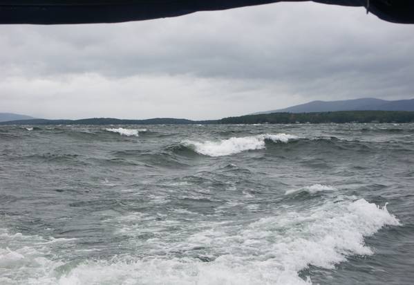 While out working I noticed many large branches and logs floating by, but there was nothing that could be done. Be careful of debris if you venture out on the water. There are lots of docks under water on both Winnipesaukee and Winnisquam. Hopefully the water will recede soon. We were shocked to see how high the water was under Mosquito Bridge over Winnisquam! Click here for my pictures taken today of the waves and high water. Last edited by webmaster; 11-19-2005 at 04:57 PM. Reason: Add photos and links to others. |
|
|
|
|
10-16-2005, 09:49 PM
|
#18 |
|
Senior Member
Join Date: Jul 2002
Location: Meredith
Posts: 1,670
Thanks: 1,183
Thanked 655 Times in 173 Posts
|
Great photos, RG. They really show how rough the lake was today. Sleepers Island is giving us some protection from the biggest waves, but even over here near Minge Cove many waves were rolling right over a number of docks today.
We recorded a wind gust of 42 mph at 11:37am this morning, and the wind is still howling tonight as well.
__________________
DRH |
|
|
|
|
10-17-2005, 07:24 AM
|
#19 |
|
Senior Member
Join Date: Jul 2002
Location: Meredith
Posts: 1,670
Thanks: 1,183
Thanked 655 Times in 173 Posts
|
High winds continued to blow overnight. We recorded a gust of 43 mph at 2:50am this morning. At 8:30am today (Monday) the winds are down quite a bit, but we're still getting occasional high gusts.
__________________
DRH |
|
|
|
|
10-17-2005, 07:52 AM
|
#20 | |
|
Senior Member

Join Date: Jan 2005
Location: Florida (Sebring & Keys), Wolfeboro
Posts: 5,788
Thanks: 2,085
Thanked 742 Times in 532 Posts
|
Quote:
 ], those branches and logs will be lodging themselves "high" around the lake . Staying relatively dry over winter, they can be "mobile" again at ice-out, 2006. ], those branches and logs will be lodging themselves "high" around the lake . Staying relatively dry over winter, they can be "mobile" again at ice-out, 2006. (2005 was bad enough for debris. Picture is of 20-minutes-worth of pulling debris. Seat cushion is for scale). 2) If you have dock-ice circulators, check them for branches lodged in them. Winnipesaukee Aquatherm advises that underwater branches cause most circulator failures. Last edited by ApS; 10-17-2005 at 08:00 AM. |
|
|
|
|
|
10-17-2005, 07:58 AM
|
#21 |
|
Senior Member
Join Date: Dec 2003
Posts: 76
Thanks: 7
Thanked 0 Times in 0 Posts
|
Has the lake level stabilized yet? or is it still rising. I was on the lake yesterday and was surprised to see how high the water was - almost over the dock at Pier 19 and part of the Tuftonboro public pier had water washing over it. With the wind out of the NW the waves were breaking on to the docks... Hopefully we will have a few days without rain and they will get the level back down to where it should be this time of year.
|
|
|
|
|
10-17-2005, 10:35 AM
|
#22 | |
|
Senior Member
Join Date: Apr 2004
Location: Brookline and Moultonborough NH
Posts: 100
Thanks: 4
Thanked 0 Times in 0 Posts
|
Quote:
It will take much more than a few days to get the lake back down to where it should be at this time of year. In fact I notice that they have backed off on how much water they are releasing at Lakeville - no doubt to lessen the strain downstream until more can drain off down there. Ken |
|
|
|
|
|
10-17-2005, 10:59 AM
|
#23 |
|
Senior Member

Join Date: Oct 2004
Location: Laconia NH
Posts: 5,512
Thanks: 3,118
Thanked 1,090 Times in 784 Posts
|
The lake was pretty wild Sunday between the high water and winds. As RG photo shows, the Broads was not the place to go boating.
I only ventured between Sleepers and Minge Cove and it was bad enough. The docks at the marina were just above water. A few boats were not maintained recently and were listing in the rear. I hope the marina staff notify the owners. One boat was listing very badly and I took it upon myself to see if I could do something temporarily. I notice the owner had shut off both batteries and the bilge pump was not operating. I switch to battery one and the bilge pump instantly came to life. A lesson to learn for all the newbies. 
__________________
Someday may never be an actual day. |
|
|
|
|
10-17-2005, 12:38 PM
|
#24 | |
|
Senior Member
Join Date: Apr 2004
Location: NH
Posts: 2,689
Thanks: 33
Thanked 439 Times in 249 Posts
|
Quote:
|
|
|
|
|
|
10-17-2005, 12:57 PM
|
#25 |
|
Senior Member
Join Date: Nov 2003
Location: Central NH
Posts: 5,252
Blog Entries: 1
Thanks: 1,451
Thanked 1,349 Times in 475 Posts
|
The water at the Lazy River Campground is beginning to recede. Yesterday at 11:30 am it was up the word campground. Today at 8:15 am, you could read next right under it.
I was able to get that dramatic shot of Downing's. (As soon as the image is approved, I will post it here.) The water is definitely higher, but the waves weren't as bad today. The bandstand's deck is now under water. On our way out to the island, we noticed that the dock at the Crow's Nest, which used to be called the Owl's Nest, is gone. The remaining boards are flopping around. For those not familiar with the island, it is on The Broads on the Alton end of the island. The lake wasn't near as rough as yesterday, but it is still very bad. (That was between 9:00 am - 11:00 am.) Thankfully the job I did tying the panels is holding up. Hopefully the docks will too! When standing on it, you get knocked around pretty good. The water level has risen more than two inches since yesterday afternoon and it is still going up. Parker Marine's rack storage is now IN the lake! (I wonder if they need a permit for in the lake rack storage? Yikes! ) The weather forecast for the weekend looks like there might be more rain. That's just what we need. I hope the lake level can go down by then. (We sure wish we had closed the camp early this year!) Last edited by Rattlesnake Gal; 10-17-2005 at 01:00 PM. |
|
|
|
|
10-17-2005, 01:00 PM
|
#26 |
|
Senior Member

Join Date: Apr 2004
Location: Wolfeboro
Posts: 521
Thanks: 10
Thanked 29 Times in 15 Posts
|
RG,
Was it a Wavy crazy day in the Broads or was it a Crazy Broad in the Broads?  Glad you made it round trip. Glad you made it round trip.
__________________
Home Permanently in NH
|
|
|
|
|
10-17-2005, 01:09 PM
|
#27 | |
|
Senior Member

Join Date: Feb 2004
Location: Mountonboro
Posts: 200
Thanks: 12
Thanked 0 Times in 0 Posts
|
Quote:
Glad you secured the docks and they are still there. Oh, the joys of island living. At least, being way up the northern tip, I do not have the large waves from the wind. Gear inside my boathouse on the deck, may be floating where it should not be. |
|
|
|
|
|
10-17-2005, 01:44 PM
|
#28 |
|
Senior Member

Join Date: Apr 2004
Location: Bear Island
Posts: 1,757
Thanks: 31
Thanked 429 Times in 203 Posts
|
I have been watching the waves roll over my dock on the BearCam. Sometimes I see the dock inserts pop up and down. If the lake goes up another couple of inches my dock sections will be in Wolfeboro. I hope they find a good home.
I think maybe I was happier when I had no idea what was going on. |
|
|
|
|
10-17-2005, 02:24 PM
|
#29 |
|
Senior Member

Join Date: Feb 2003
Location: Cow Island
Posts: 914
Thanks: 602
Thanked 193 Times in 91 Posts
|
Bear Islander....I think your owl is going for a swim soon.
|
|
|
|
|
10-17-2005, 04:54 PM
|
#30 | |
|
Senior Member

Join Date: Jul 2002
Location: Rock Haven Lake - West Newfield, ME
Posts: 5,361
Thanks: 374
Thanked 1,044 Times in 490 Posts
|
Quote:
|
|
|
|
|
|
10-17-2005, 04:56 PM
|
#31 | ||
|
Senior Member
Join Date: Nov 2003
Location: Central NH
Posts: 5,252
Blog Entries: 1
Thanks: 1,451
Thanked 1,349 Times in 475 Posts
|
I'd say it was a wavy crazy day in the Broads and there was a crazy broad out there too!
FLBoater, you crack me up! Quote:
Quote:
Here are my photos from today. |
||
|
|
|
|
10-17-2005, 07:32 PM
|
#32 |
|
Senior Member

Join Date: Jan 2005
Posts: 3,360
Thanks: 210
Thanked 764 Times in 448 Posts
|
Another wavy day in paradise today! My jet skiis floated off their lifts and decided to make a voyage on their own, one further down Mark and the other over to Bear. A big thanks to Steve from Island Support for dragging them back to our place and securing them while I was on the way up today. Overall not too much damage, just a lot of gelcoat scrapes on the bottoms from hitting on the rocks on shore. A relative of mine over by Trexlers had a similar experience, if you have skiis on lifts still in the water you'd better check them asap!
It certainly was an adventure riding them back across to Glendale today, the few boaters that I passed must have thought I was nuts being our there in the wind and waves. I think that I spent more time in the air than in the water. Probably a good thing, it was quite cold! The wind gave that extra cold sting to wet exposed extremeties. There was definitely a lot of debris by Mark, the remnants of someones dock panels were washed up against the mail dock. One of the permanent docks on Mink (it might even be Mink Islanders, not sure which is his but he is in that area) was completely under water, the level was 2" below my decking on our crib but all was safe. I think that this year is about over for me, we are shutting down this weekend but will probably leave the boats in for a few more weeks. |
|
|
|
|
10-17-2005, 07:52 PM
|
#33 |
|
Senior Member
Join Date: Jan 2005
Posts: 2,084
Thanks: 1,267
Thanked 557 Times in 286 Posts
|
RG:
Your pictures of the "surf" were great. That being said, photos of waves never do them justice. They are much nastier when you are bouncing around in them on a boat. I wonder if Glove and Plut would reconsider their comments about a 20 foot boat being adequate equipment for the big lake after being out in conditions like we have had recently? |
|
|
|
|
10-18-2005, 12:07 PM
|
#34 |
|
Senior Member
Join Date: Feb 2003
Location: Moultonboro, NH
Posts: 1,657
Blog Entries: 1
Thanks: 342
Thanked 618 Times in 278 Posts
|
With the lake at record levels, there is about 27 billion gallons of water that need to be released from the lake before its down to "draw-down" level. I don't have my formula book handy, but 27 billion gallons sitting at 505 feet above sea level represents a LOT of potential energy. A quick google search http://www.tsgc.utexas.edu/archive/d...rage/full.html indicates that a constant 30 megawatts per hour could be generated for 40 days. Too bad most of it cannot be harvested. Does anyone know how much electricity is actually generated along the water path from Winnipesaukee to the sea?
__________________
-lg |
|
|
|
|
10-18-2005, 10:06 PM
|
#35 |
|
Senior Member
Join Date: Sep 2003
Posts: 1,943
Thanks: 23
Thanked 111 Times in 51 Posts
|
Looking at the lake level it seems to have stopped rising but it's still not falling
 At this time the output from the dam has climbed back up to it's max rate so hopefully the waters will start to recede soon. I'm a bit worried as the data show a rise of perhaps 3-4 in from when we were there last. At that time the water was lapping at the bottom of the dock and now it has to be over the top boards, at least on the outer, lower end. I'm hoping it hasn't pulled a "mcdude" on us, taking the Mee'n'Mac for a ride along with it. I'm guessing our neighbor who was still around Monday (now departed for FL) would have let us know if anything drastic had happened..... At this time the output from the dam has climbed back up to it's max rate so hopefully the waters will start to recede soon. I'm a bit worried as the data show a rise of perhaps 3-4 in from when we were there last. At that time the water was lapping at the bottom of the dock and now it has to be over the top boards, at least on the outer, lower end. I'm hoping it hasn't pulled a "mcdude" on us, taking the Mee'n'Mac for a ride along with it. I'm guessing our neighbor who was still around Monday (now departed for FL) would have let us know if anything drastic had happened.....RG - great pics of Parker Marina, Alton Gazebo and Downing's dock. Given the questionable integrity of the latter, I wonder if it will be around when the waters recede ? I wonder how large Sunday's waves out on the Broads would have measured ? Glad we didn't get the same hammering down in Alton Bay, the wind was enough as it was.
__________________
Mee'n'Mac "Never attribute to malice that which can be explained by simple stupidity or ignorance. The latter are a lot more common than the former." - RAH |
|
|
|
|
10-18-2005, 10:26 PM
|
#36 | |
|
Senior Member
Join Date: Sep 2003
Posts: 1,943
Thanks: 23
Thanked 111 Times in 51 Posts
|
Quote:
I can only hope it retreats (some) this week ! Imagining the number of dock failures from the high water + wind + waves, ice out 2006 will be a banner year for debris. We seemed to have collected a lot of froth, pine needles and small twigs so far these past storms. Well those and one signed Kent Hrbek baseball, which seems in good shape after it's swim
__________________
Mee'n'Mac "Never attribute to malice that which can be explained by simple stupidity or ignorance. The latter are a lot more common than the former." - RAH |
|
|
|
|
|
10-19-2005, 08:15 PM
|
#37 |
|
Senior Member
Join Date: Dec 2003
Posts: 76
Thanks: 7
Thanked 0 Times in 0 Posts
|
It is interesting to see that this thread has come full circle - from a lake so low... to a lake too high... I noted this evening that the DES chart had the lake toppng the 505 foot make for the first time... but also that the outflow at the dam has been dramatically increased. Most likely in an effort to draw the level down some before the rains that are forecast for this weekend. Our dock was 6" above water when I was there on Sunday and the lake has risen 3" since then... with luck nothing has floated away yet... we will be closing up this weekend and so will put the worries of high water behind us until spring... best of luck to all who still have boats and docks in...

|
|
|
|
|
10-19-2005, 08:45 PM
|
#38 |
|
Member
Join Date: Apr 2004
Posts: 39
Thanks: 1
Thanked 4 Times in 2 Posts
|
We're heading up to the bay this weekend, hopefully to close up shop. Thanks to all for posting about the lake level. We were up there last weekend and the water was up to the bottom of the dock; probably over the top now if the latest postings are accurate. Hope the boat's still there.
Came up two weeks ago to see the water level rise over 12 inches in 48 hours; incredible. Perhaps the authorities will be posting a lake-wide no-wake zone as they did a few years ago. Anyway, did some quick (very quick) math, and came up with a little over one-and-a-half TRILLION gallons of water needed to bring the 72 square miles of lake up one foot. Lots of electricity in there for the taking when they let it out. |
|
|
|
|
10-20-2005, 07:58 PM
|
#39 | |
|
Senior Member
Join Date: Jan 2005
Location: Florida (Sebring & Keys), Wolfeboro
Posts: 5,788
Thanks: 2,085
Thanked 742 Times in 532 Posts
|
Quote:
You still must weigh whether to go out there or not, given all the variables -- including your boat handling skills. "Getting-home-itis" is to tempt Fate. Sometimes "a fishing trip" is poorly advised. |
|
|
|
|
|
10-21-2005, 09:11 AM
|
#40 |
|
Senior Member
Join Date: Jul 2004
Posts: 658
Thanks: 121
Thanked 283 Times in 98 Posts
|
I am off for at least part of this weekend and if you are stuck in Florida, Pennsyltucky or Iraq, etc. and are concerned about your place give me a call 603-455-7178 and I'll putt on by and check on it for you. What are friends for?
Misty Blue |
|
|
|
|
10-21-2005, 12:04 PM
|
#41 |
|
Senior Member
Join Date: Nov 2003
Location: Central NH
Posts: 5,252
Blog Entries: 1
Thanks: 1,451
Thanked 1,349 Times in 475 Posts
|
Misty, you are so nice to offer up your services!
Have you been flooded with calls yet? DRH was wonderful enough to check on our place on Tuesday. It really eased our minds. Thanks again DRH! See you on the lake.
|
|
|
|
|
10-21-2005, 03:58 PM
|
#42 |
|
Senior Member
Join Date: Jul 2002
Location: Rock Haven Lake - West Newfield, ME
Posts: 5,361
Thanks: 374
Thanked 1,044 Times in 490 Posts
|
Misty:
What a generous offer. Thanks so much! You gotta love this forum! McD
|
|
|
|
|
10-21-2005, 04:16 PM
|
#43 |
|
Member

Join Date: Apr 2004
Posts: 40
Thanks: 0
Thanked 0 Times in 0 Posts
|
what is the lake at now (level?)
__________________
live today like you wont live tomorrow |
|
|
|
|
10-21-2005, 05:49 PM
|
#44 |
|
Senior Member
Join Date: Jan 2005
Posts: 2,084
Thanks: 1,267
Thanked 557 Times in 286 Posts
|
Misty:
Be careful out there, the water is chilling down quickly. Wear your PFD. |
|
|
|
|
10-22-2005, 03:18 PM
|
#45 |
|
Senior Member
Join Date: Sep 2003
Posts: 1,943
Thanks: 23
Thanked 111 Times in 51 Posts
|
Despite MB's generous offer, I made a quick trip to check that our dock hadn't gone "mcdude" on us (it hadn't). Interestingly the water wasn't as high as I had feared. It was only slightly more than last Sunday's level despite the readings at Lakeport. I can only guess the wind was piling up the water last weekend and when it stopped blowing it was replaced by this weeks rise. I put the equivalent of a good NFL defensive line on the dock ala FLL's water weights and so should be OK despite what rain comes in the next few days. I just checked the lake level and it is presently receding (maybe 1" in last 24 hrs) so it appears the tide is headed out (for now
). Looking up and down Alton Bay I could see sticks and logs and miscellaneous flotsam everywhere, big stuff too. No way would I be out at night like I saw 1 person doing. As I passed the "roped off" Alton Bay beach I had a new concept of what a perched beach was. Not one held back by a wall but rather one where the perch swim to sun themselves.
__________________
Mee'n'Mac "Never attribute to malice that which can be explained by simple stupidity or ignorance. The latter are a lot more common than the former." - RAH |
|
|
|
|
10-22-2005, 03:24 PM
|
#46 |
|
Junior Member
Join Date: Oct 2005
Posts: 2
Thanks: 0
Thanked 0 Times in 0 Posts
|
Thank you all for the information on the lake situation, and particularly for the web sites with lake levels.
I'm in Rochester, NY, 8 hours from Wolfeboro, and without knowing lake levels, I don't know when I can begin dock repairs. No point in coming to look at a submerged dock. I see that the levels are dropping slowly, but we're sending some more rain your way. Thanks again |
|
|
|
|
10-22-2005, 05:07 PM
|
#47 |
|
Senior Member
Join Date: Jul 2002
Location: Rock Haven Lake - West Newfield, ME
Posts: 5,361
Thanks: 374
Thanked 1,044 Times in 490 Posts
|
Mee-n-Mac:
We'd love to see a photo of those perch sunning at the beach. Were they sunning in such a way so as to look like a wall?.....a perched wall? Perhaps a photo along the lines of the one you posted of the spaceship on top of the stone tower so we could all see what this perched beach looks like? .....and I notice that my formal name "mcdude" (my honest-to- goodness God-given name BTW) has now become a verb. I am honored. 1 mcdude \ mick ~ dewd \ v. [from the Mee-n-Mac dialect] 1: to float away in high water as in flood conditions - as in a permanent or semi-permanent object such as a dock.  Object subject to "mcduding"?????????????? Last edited by mcdude; 10-22-2005 at 05:15 PM. |
|
|
|
|
10-22-2005, 05:48 PM
|
#48 |
|
Senior Member
Join Date: Apr 2004
Location: Wolfeboro
Posts: 521
Thanks: 10
Thanked 29 Times in 15 Posts
|
Does McDude go mcduding down the McDude River??
__________________
Home Permanently in NH
Last edited by KBoater; 10-22-2005 at 06:09 PM. |
|
|
|
|
10-22-2005, 09:57 PM
|
#49 | |
|
Senior Member
Join Date: Sep 2003
Posts: 1,943
Thanks: 23
Thanked 111 Times in 51 Posts
|
Quote:
ps - Good work on Chapter 5. I can see this becoming a school play ...
__________________
Mee'n'Mac "Never attribute to malice that which can be explained by simple stupidity or ignorance. The latter are a lot more common than the former." - RAH |
|
|
|
|
|
10-23-2005, 12:42 AM
|
#50 | |
|
Senior Member
Join Date: Sep 2003
Posts: 1,943
Thanks: 23
Thanked 111 Times in 51 Posts
|
Quote:
__________________
Mee'n'Mac "Never attribute to malice that which can be explained by simple stupidity or ignorance. The latter are a lot more common than the former." - RAH |
|
|
|
|
|
10-23-2005, 05:39 AM
|
#51 |
|
Senior Member
Join Date: Jan 2005
Location: Florida (Sebring & Keys), Wolfeboro
Posts: 5,788
Thanks: 2,085
Thanked 742 Times in 532 Posts
|
It's FLL-rated! (And not too soon...it's been raining steadily since early this morning).
Those following Hurricane Wilma just found out this morning that a series of three new tropical storms are expected to combine and bring bad weather/rain to the Gulf of Maine. I missed whether they are to precede Hurricane Wilma's effects here or follow it. (Thursday's forecast mentioned a Wilma-glance of Cape Cod / Nova Scotia)My dock is nailed and chained together, so there's no need to buy garbage cans. 'Hope Lakeport is reading these forecasts, though. With the lake touching the dock, it's a good time to check the "levelness" of our docks. I see Mee'n'Mac's is slightly out of kilter, just as mine is. With so much ice damage around the lake in 2002 -- and no barges available in June -- I had to fix my dock with levers, hoist-winches, and water pressure. (A water-circulater failed when some object shredded the propeller). In my case, the ice pushed the near pilings in some. The repair couldn't lower the "near" pilings by very much. Last edited by ApS; 10-23-2005 at 07:07 AM. Reason: Dock level |
|
|
|
|
10-23-2005, 08:09 AM
|
#52 |
|
Senior Member
Join Date: Feb 2003
Location: Moultonboro, NH
Posts: 1,657
Blog Entries: 1
Thanks: 342
Thanked 618 Times in 278 Posts
|
During that sad boat trip to the launch for the final journey of the year, I got some shots of docks that were looking a bit low. Overall, most folks don't have to worry if the lake doesn't come up more than a few more inches.
__________________
-lg |
|
|
|
|
10-23-2005, 07:11 PM
|
#53 |
|
Senior Member
Join Date: Mar 2004
Location: Clifton, NJ, Alton Bay
Posts: 819
Thanks: 245
Thanked 224 Times in 130 Posts
|
Thanks for the picture looking out at Sandy Point. I miss the place already. Heard from our friends on Loon Island that they had to raise the boat house doors a few inches to get them out of the water. Hopefully Wilma won't dump too much more rain on the place.
|
|
|
|
|
10-23-2005, 09:39 PM
|
#54 |
|
Senior Member
Join Date: Jan 2003
Location: Alton Bay
Posts: 5,547
Blog Entries: 2
Thanks: 2,398
Thanked 1,918 Times in 1,061 Posts
|
M-n-M, as I headed out to the dump, er landfill, er transfer station, I did take a look at your docks and the "sentries" were still standing tall early Sunday afternoon.
Special statement on the weather channel relating to Wilma came across the TV this afternoon : Looking at high winds and up to 2-4 inches of rain possible. I think this link will get us to that statement. http://www.weather.com/weather/local...from=whatwhere And I did hear a boat night before last that sounded like it was up on plane leaving Alton bay. With all the junk out there, it would be headway speed and spotlight for me!!!!!
__________________
I Live Here... I am always UPTHESAUKEE !!!! |
|
|
|
|
10-23-2005, 10:51 PM
|
#55 |
|
Senior Member
Join Date: Nov 2003
Location: Central NH
Posts: 5,252
Blog Entries: 1
Thanks: 1,451
Thanked 1,349 Times in 475 Posts
|
Rattlesnake Guy and I took a field trip to a few dams today.
Lakeport Lakeport II Northfield/Tilton Franklin |
|
|
|
|
10-24-2005, 12:05 AM
|
#56 |
|
Junior Member

Join Date: Oct 2005
Location: Somewhere south of the White Mtns.
Posts: 9
Thanks: 0
Thanked 0 Times in 0 Posts
|
What a flow, I have never seen the dams running like that.....
__________________
FREEDOM OF SPEACH IS A RIGHT, NOT A PRIVLEDGE.....
|
|
|
|
|
10-24-2005, 06:41 AM
|
#57 |
|
Senior Member
Join Date: Jul 2002
Location: Rock Haven Lake - West Newfield, ME
Posts: 5,361
Thanks: 374
Thanked 1,044 Times in 490 Posts
|
Hi RG:
Very nicely done mini-movies! Were those taken with your digital cam? McD |
|
|
|
|
10-24-2005, 08:12 AM
|
#58 |
|
Senior Member
Join Date: Nov 2003
Location: Central NH
Posts: 5,252
Blog Entries: 1
Thanks: 1,451
Thanked 1,349 Times in 475 Posts
|
I used my DiMAGE A2. (Not the video camera.) The files were much larger and better quality, but smaller files are easier for members to view.
During the commercials on Desperate Housewives, I kept running to the computer to try and upload the video to the site, without avail. At 11:00 pm R-Guy came to the rescue. The files were too large and not the right type, so he resized them. That didn't work either, so he let me upload them to his site. He is so good to me.  (Unfortunately that will expire soon. ) (Unfortunately that will expire soon. )Can video be uploaded on the forum? |
|
|
|
|
10-24-2005, 08:31 AM
|
#59 |
|
Senior Member
Join Date: Nov 2003
Location: Central NH
Posts: 5,252
Blog Entries: 1
Thanks: 1,451
Thanked 1,349 Times in 475 Posts
|
Saturday afternoon as we were heading out, we noticed many docks that have been winched up before the water level increased so dramatically. They have many posts that are in the water. Will we see more wreaked docks in the spring than usual or perhaps Wilma will make this fall debris?
Be careful everyone. |
|
|
|
|
10-24-2005, 08:06 PM
|
#60 | |
|
Senior Member
Join Date: Apr 2004
Posts: 1,325
Thanks: 5
Thanked 0 Times in 0 Posts
|
Quote:
http://www.rattlesnakecam.com/steamboat.htm |
|
|
|
|
|
10-25-2005, 06:28 AM
|
#61 |
|
Senior Member

Join Date: Jul 2002
Location: Central MA
Posts: 2,352
Thanks: 18
Thanked 535 Times in 179 Posts
|
I just wanted to thank Bizer for the frequent updates to his lake level chart during this very unusual October. It helps a lot to see the levels and the comparisons to other years.... and the link to the State's lake level chart.
Thanks again, I for one appreciate your work! IG
__________________
Island Girl ....... Make Lemonade |
|
|
|
|
10-25-2005, 01:01 PM
|
#62 |
|
Senior Member
Join Date: Mar 2004
Location: Piscataway, NJ
Posts: 1,030
Thanks: 2
Thanked 46 Times in 24 Posts
|
Is the lakes region expecting any HEAVY Rain from the remnants of Wilma heading north? Its been raining down here since last evening!
Last edited by gtxrider; 10-25-2005 at 01:02 PM. Reason: editing |
|
|
|
|
10-25-2005, 01:40 PM
|
#63 | |
|
Senior Member
Join Date: Jul 2002
Location: Meredith
Posts: 1,670
Thanks: 1,183
Thanked 655 Times in 173 Posts
|
Quote:
__________________
DRH |
|
|
|
|
|
10-25-2005, 03:04 PM
|
#64 |
|
Senior Member
Join Date: Mar 2004
Location: Piscataway, NJ
Posts: 1,030
Thanks: 2
Thanked 46 Times in 24 Posts
|
Isn't strange that this thread started because of a low lake level?

|
|
|
|
|
11-01-2005, 09:47 PM
|
#65 | |
|
Senior Member
Join Date: Sep 2003
Posts: 1,943
Thanks: 23
Thanked 111 Times in 51 Posts
|
Quote:
Should get some interesting lake pics during the farewell cruise.
__________________
Mee'n'Mac "Never attribute to malice that which can be explained by simple stupidity or ignorance. The latter are a lot more common than the former." - RAH |
|
|
|
|
|
11-06-2005, 10:01 PM
|
#66 |
|
Junior Member
Join Date: Oct 2005
Posts: 7
Thanks: 0
Thanked 0 Times in 0 Posts
|
Has the Lake level decreased enough that docks can be raised for the winter?
My dock on Morrison Cove had about six inches of water over the deck two we and about three inches last weekend. Has the Lake level decreased four inches in the last week? Also, I'm told a Mr. Fay in is charge of regulating the Lake level. What are his qualifications? Is he a cerftified hydrologist? Is a NH State employee or does he work for the owners of the dam? There are legal questions of responsibilty for damages to property if there is any negligence on the part of the dam owners or if those making dcisions are not qualified. No one has asked these questions or answered them, to the nest of my knowledge. I would like to have these answers if anyone on line can assist. Thanks. doc |
|
|
|
|
11-07-2005, 05:50 AM
|
#67 |
|
Senior Member
Join Date: Jul 2002
Location: Central MA
Posts: 2,352
Thanks: 18
Thanked 535 Times in 179 Posts
|
Bob Fay does an outstanding job operating that dam. If you watch the water levels, weather and all that goes into filling and emptying the lake you will see that he is eminently qualified. I am amazed that the lake is as well controlled as it is given all the migigating factors. He can't control 10-12 inches of rainfall and all the runoff.
__________________
Island Girl ....... Make Lemonade |
|
|
|
|
11-07-2005, 08:09 AM
|
#68 | |
|
Senior Member
Join Date: Jul 2002
Location: Meredith
Posts: 1,670
Thanks: 1,183
Thanked 655 Times in 173 Posts
|
Quote:
__________________
DRH |
|
|
|
|
|
11-08-2005, 08:01 PM
|
#69 | |
|
Senior Member
Join Date: Sep 2003
Posts: 1,943
Thanks: 23
Thanked 111 Times in 51 Posts
|
Quote:
http://www.winnipesaukee.com/forums/...22551#poststop
__________________
Mee'n'Mac "Never attribute to malice that which can be explained by simple stupidity or ignorance. The latter are a lot more common than the former." - RAH |
|
|
|
|
|
11-08-2005, 09:54 PM
|
#70 | |
|
Senior Member
Join Date: Apr 2004
Posts: 1,325
Thanks: 5
Thanked 0 Times in 0 Posts
|
Quote:
If you really need answers, then contact the state. If you are afraid of personal contact, then write DES in Concord for a response. |
|
|
|
|
|
11-08-2005, 11:04 PM
|
#71 |
|
Junior Member
Join Date: Oct 2005
Posts: 7
Thanks: 0
Thanked 0 Times in 0 Posts
|
DHR / GWC
Thank you for the information. I have no complaints with Mr. Fay, I just wanted to know his qualifications. As a NH State employee I am sure he is qualified as a hydrologist or supervised by one. If anyone knows the Lake level at the present time (Is it down further from the weekend), I would appreciate that. I'd like to raise my dock before it winter freeze but I guess it would be cold this weekend either way. Thanks. doc |
|
|
|
|
11-09-2005, 12:07 AM
|
#72 | |
|
Senior Member
Join Date: Sep 2003
Posts: 1,943
Thanks: 23
Thanked 111 Times in 51 Posts
|
Quote:
http://www.des.state.nh.us/rti_data/wein3_TABLE.HTML
__________________
Mee'n'Mac "Never attribute to malice that which can be explained by simple stupidity or ignorance. The latter are a lot more common than the former." - RAH |
|
|
|
|
|
11-09-2005, 09:01 PM
|
#73 |
|
Senior Member
|
Methinks it is time to dump the water out of those trash cans and to start using them for leaf hauling. Looks like the water level is back to early June levels so it's about time to get out and go boating again. Unless, you have to rake leves or shovel slush. Driving up the hill to WV was a slippery slushy mess tonight. Methinks it's time to load the bags of sand into the back of the old pickup...even though winter is still a month or more away. Water, water & more water but never even considered getting any flood insurance. Totally not needed on the big lake. It never floods over!
|
|
|
|
|
11-10-2005, 07:41 AM
|
#74 | |
|
Senior Member
Join Date: Jan 2005
Location: Florida (Sebring & Keys), Wolfeboro
Posts: 5,788
Thanks: 2,085
Thanked 742 Times in 532 Posts
|
I suspect a hydrologist would know that development is a significant contributor to the rapid Winnipesaukee water level increases.
For centuries, the forests have acted like a sponge to keep the velocity of rain runoff moderated. (Providing us a clean, clear, "Class A" lake. Now it's a "B" -- and there is no "Class C"). Things have changed in the last 20 years: When you build houses, garages, mini-warehouses, dry boat-storage facilities, then pave over woodlands for parking lots, ditches, new roads, culverts and driveways, the velocity of rain runoff has to increase. The rapidity-extremes and height-extremes of the lake's rise are affected, but also the quality of water feeding into it. That is why this thread got posted (Who's in Charge?) in General Discussions. There don't appear to be adequate state guidelines in temporarily trapping / sequestering runoff (which resulted in both of my neighbors' leachfields being washed into the lake following rainfall from the development "upstream"). Earlier this season, photos were placed here concerning backyard "roaring rapids". I wonder what's upstream from there? Quote:
|
|
|
|
|
|
11-18-2005, 05:41 AM
|
#75 |
|
Senior Member
Join Date: Dec 2003
Posts: 76
Thanks: 7
Thanked 0 Times in 0 Posts
|
Judging by the rate they have been able to draw down the lake over the last few weeks, and providing we do not have any more extreme rainfall events, it looks like it will be late December before they will have the lake down to the customary winter level. I wonder if they will be able to accomplish this before the ice sets in. And what are the effects downstream of the huge out flow at the dam for such an extended period? It will be interesting to watch over the next few weeks and months.
|
|
|
|
|
11-18-2005, 07:14 AM
|
#76 |
|
Senior Member
Join Date: Jul 2004
Location: Cape Cod / W.Alton
Posts: 76
Thanks: 4
Thanked 9 Times in 5 Posts
|
I would THINK that as long as they got the water levels down before ICE OUT, the damage would be kept minimal. They should be able to run off more water even after some ice has set in. The down side to that would be possible hollow spots in the ice, and uneven surfaces, making for dangerous snowmobiling.
|
|
|
|
|
11-18-2005, 11:07 PM
|
#77 | |
|
Senior Member
Join Date: Jan 2003
Location: Alton Bay
Posts: 5,547
Blog Entries: 2
Thanks: 2,398
Thanked 1,918 Times in 1,061 Posts
|
Quote:
In order for trees and grasses to absorb water, there has to be some absorbtion capability in the soil. With the volume of rain we had, twice, that capability was eliminated, and all that could happen is a run off to the lowest point in the neighborhood...which in this area happens to be Lake Winnipesaukee. Has building increases, use of phosphates near the lake and its tributaries, and increased boat traffic contributed to the clouding of the lake. I'm sure it has. However the amount of rain we incurred in the area in a very short period of time would have overwhelmed the land regardless. And having three years in the last 25 or so with "record" high lake heights is simply Mother Nature's way of reminding us of who's really in charge!
__________________
I Live Here... I am always UPTHESAUKEE !!!! |
|
|
|
|
|
| Bookmarks |
|
|


 Linear Mode

