

|
|
|
|
|
|||||||
| Home | Forums | Gallery | Webcams | Blogs | YouTube Channel | Classifieds | Calendar | Register | FAQ | Donate | Members List | Today's Posts | Search |
 |
|
|
Thread Tools | Display Modes |
|
|
 08-21-2015, 08:46 AM
|
#1 |
|
Senior Member

Join Date: Aug 2004
Posts: 75
Thanks: 8
Thanked 9 Times in 9 Posts
|
Took the kayak out to the witches this AM. Just off the main rock pile is a complete Merc lower drive unit with dual stainless steel props. Looks fairly clean, so I am thinking it must be from this summer.
|

|

|
|
08-21-2015, 09:41 AM
|
#2 |
|
Senior Member
Join Date: Feb 2008
Location: Gilford, NH / Welch Island
Posts: 5,936
Thanks: 2,291
Thanked 4,943 Times in 1,918 Posts
|
Pretty sure that occurred this past Sunday. I was coming back from the Weirs heading to Welch and was passed by two marine patrol boats just on the west side of the witches. I then saw someone with a boat load of people right in the middle of the witches completely broken down waving down marine patrol. They were very lucky if all they lost was the lower unit. There had to be 8-10 people on that boat and it wasn't very big...
Dan
__________________
It's Always Sunny On Welch Island!! 
Last edited by ishoot308; 08-21-2015 at 12:22 PM. |
|
|
|
|
08-21-2015, 10:44 AM
|
#3 |
|
Senior Member

Join Date: Nov 2003
Location: Central NH
Posts: 5,252
Blog Entries: 1
Thanks: 1,451
Thanked 1,349 Times in 475 Posts
|
Why aren't the Witches marked better? Those balls that are at Sandy Point would be very visible in all conditions.
|
|
|
|
| The Following User Says Thank You to Rattlesnake Gal For This Useful Post: | ||
Smith Point (08-23-2015) | ||
|
08-21-2015, 11:29 AM
|
#4 |
|
Senior Member
Join Date: Jun 2007
Posts: 298
Thanks: 14
Thanked 147 Times in 62 Posts
|
I personally think they are marked just fine as is. I would rather not see a line of bouys around the witches, nor the graveyard, nor the six pack nor a thousand other hazards in the lake. I would rather folks use their charts and understand where they should be and not be based on their comfort.
Where would we draw the line? A person navigating this lake without a chart and basic understanding of the navigation hazards will get in trouble regardless of additional hazard markers. The lake has a little under 300 miles of shoreline and within 150' of all this shore is peppered with hazards. |
|
|
|
| The Following 8 Users Say Thank You to NH_boater For This Useful Post: | ||
billy (08-23-2015), BroadHopper (08-22-2015), CooperS7777 (08-23-2015), Descant (08-21-2015), JTA (08-22-2015), Misha888 (08-24-2015), upthesaukee (08-21-2015), VitaBene (08-21-2015) | ||
|
08-21-2015, 11:59 AM
|
#5 | |
|
Senior Member
Join Date: Feb 2008
Location: Gilford, NH / Welch Island
Posts: 5,936
Thanks: 2,291
Thanked 4,943 Times in 1,918 Posts
|
Quote:
Dan
__________________
It's Always Sunny On Welch Island!!
|
|
|
|
|
| The Following 3 Users Say Thank You to ishoot308 For This Useful Post: | ||
| Sponsored Links |
|
|
|
08-21-2015, 01:40 PM
|
#6 |
|
Senior Member
Join Date: Mar 2008
Location: Welch Island and West Alton
Posts: 3,219
Thanks: 1,175
Thanked 2,003 Times in 915 Posts
|
At times the lighting is such that the markers are easy to spot from quite a distance. At other times not so much, you have to know almost exactly where they are and really be trying to focus in. The fact that so many boats are damaged there is evidence that more prominent marking would serve well.
Remember the dive boat? http://www.winnipesaukee.com/forums/...e+boat+witches |
|
|
|
|
08-21-2015, 02:34 PM
|
#7 |
|
Senior Member

Join Date: Apr 2004
Location: North Shore, MA
Posts: 1,352
Thanks: 987
Thanked 310 Times in 161 Posts
|
While I agree that if you know how to read a chart and navigate, the Witches should never be a problem. Only time it could be would be a sudden fog, but that hardly ever happens. This is a lake, not the ocean.
That said, a well designed, small stone lighthouse might add additional character to this beautiful lake. R2B |
|
|
|
| The Following 2 Users Say Thank You to Resident 2B For This Useful Post: | ||
CooperS7777 (08-23-2015), Smith Point (08-23-2015) | ||
|
08-21-2015, 03:24 PM
|
#8 | |
|
Senior Member

Join Date: Jan 2006
Posts: 6,416
Thanks: 720
Thanked 1,383 Times in 959 Posts
|
Quote:
|
|
|
|
|
|
08-21-2015, 04:26 PM
|
#9 |
|
Senior Member
Join Date: Mar 2006
Location: Merrimack and Welch Island
Posts: 4,046
Thanks: 1,215
Thanked 1,521 Times in 985 Posts
|
1. Post here long tirade about seeing buoys, slowing down and using your compass and chart; don't rely just on GPS and buoys.
2. Post here ridiculous suggestion that DES, F & G and MP work out a plan for removing hazardous rocks as in the past. Sell them to contractors. They used to mine the Witches for free. |
|
|
|
|
08-21-2015, 07:08 PM
|
#10 |
|
Senior Member

Join Date: Oct 2006
Posts: 121
Thanks: 0
Thanked 33 Times in 24 Posts
|
The yellow balls are thereto denote a swimming area, and boats under power are supposed to maintain 150'. Yea right... I've seen boats fly by swim balls or swim lines at 25' with smimmers in the water. If you can read a chart or understand navigation markers ... There should be no issue navigating near the witches or orher hazards.
|
|
|
|
|
08-21-2015, 08:19 PM
|
#11 |
|
Senior Member
Join Date: Apr 2014
Posts: 519
Thanks: 227
Thanked 167 Times in 108 Posts
|
Ive done some powerboating and a ton of paddling across many dozens of Canadian shield lakes. They are not "rocky", they ARE rock. Crazy dimensions. Hundred foot cliffs that plunge another hundred or more below the waterline. Boulders the size of houses randomly scattered. Reefs any where. Several lakes bigger than Winni. BUT Winni is in a class of her own. So many prop eaters, many in completely surprising places, and then more after that. This is graduate level lake navigation. I, for one, LOVE the complexity, mostly for the fish habitat and protection from the big cruisers and the skiers. I totally get how newbies come here, hear the warnings (or not), and get into trouble. Other lakes just are not like this one.
Now, I do think "buoys" that look like twigs is a bit too little. Then again, if that scares a few folks off, well then, more for me! |
|
|
|
|
08-22-2015, 06:11 AM
|
#12 | |
|
Moderator

|
Quote:
http://www.winnipesaukeeforum.com/ar...cgi?read=22396 Here's one idea ") : :
|
|
|
|
|
| The Following User Says Thank You to webmaster For This Useful Post: | ||
Rattlesnake Gal (08-23-2015) | ||
|
08-22-2015, 06:34 AM
|
#13 |
|
Senior Member

Join Date: Jul 2005
Location: Berlin, Ma / Gilford
Posts: 1,931
Thanks: 445
Thanked 604 Times in 340 Posts
|
Plus, look at the free adverising you get out it with "Winni.com" written on it
 Just couldn't resist ! .
__________________
A bad day on the Big Lake (although I've never had one) - Still beats a day at the office!! |
|
|
|
|
08-23-2015, 12:05 PM
|
#14 |
|
Senior Member
Join Date: Apr 2004
Location: Smith Point/ Bangor ME
Posts: 193
Thanks: 196
Thanked 35 Times in 18 Posts
|
I was out with my fishing buddy (Captain Jay) about 3 weeks ago looking for new fishing spots we started at the lady of the lakes (way to much boat traffic) and headed toward Locks Island, (not much luck there either) so we pulled up the trolling motor and headed to the witches, (hadnt fished there in a while) boy they came up on us fast! The witches are not marked well at all!
There needs to be the bigger hazard buoys! Not just the little 3 red and black buoys but the big 12 hazard and rock buoys! Now before you guys ream me a new one for not having any navigational skills, I have been on the lake for 55 years and know it well, plus I have a certified captain on board, its a fine line between trying to read a chart at 45mph (imposable) bouncing around and keeping a look out for boater traffic. Does anybody else think that the witches need better marked? |
|
|
|
| The Following 3 Users Say Thank You to Smith Point For This Useful Post: | ||
|
08-23-2015, 12:56 PM
|
#15 | |
|
Senior Member
Join Date: Feb 2008
Location: Gilford, NH / Welch Island
Posts: 5,936
Thanks: 2,291
Thanked 4,943 Times in 1,918 Posts
|
Quote:
Dan
__________________
It's Always Sunny On Welch Island!!
|
|
|
|
|
| The Following 2 Users Say Thank You to ishoot308 For This Useful Post: | ||
noreast (08-23-2015), Smith Point (08-24-2015) | ||
|
08-23-2015, 07:42 PM
|
#16 |
|
Senior Member
Join Date: Sep 2009
Location: Moultonborough, NH
Posts: 1,515
Thanks: 394
Thanked 527 Times in 269 Posts
|
I think most marina's on the lake like the markers just the way they are. Their service departments are always busy.
|
|
|
|
| The Following 2 Users Say Thank You to Greene's Basin Girl For This Useful Post: | ||
Dave R (08-24-2015), Smith Point (08-25-2015) | ||
|
08-24-2015, 08:58 AM
|
#17 |
|
Senior Member

Join Date: Jul 2004
Posts: 2,974
Thanks: 246
Thanked 736 Times in 438 Posts
|
I am perfectly capable of dealing with Winni ATONs but, I would love to see NH adopt a better marking system.
The witches (and other similar hazards that are not near shore) could be easily surrounded by standard hazard markers that would be far easier to see. Bright orange on white is much more visible than red over white or black over white, and the current marker diameter is too small. Standard underwater hazard markers: 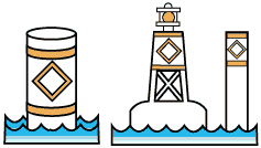 Hazards near shore could be marked with these:  Which everyone (that boats outside of NH...) knows means don't pass between marker and shore. Channels like the 6 pack and Graveyard should stay marked as-is, but I would live to see the number of marked channels expanded to include areas like north and west of Dow Island. The spars there practically mark a channel now, why not just make it official so there's no possibility of thinking the proper thing to do is go around the markers rather than through them? |
|
|
|
| The Following 6 Users Say Thank You to Dave R For This Useful Post: | ||
Greene's Basin Girl (08-24-2015), mhtranger (08-24-2015), noreast (08-24-2015), Resident 2B (08-24-2015), Smith Point (08-24-2015), trfour (08-24-2015) | ||
|
08-24-2015, 03:12 PM
|
#18 |
|
Senior Member
Join Date: Mar 2006
Location: Merrimack and Welch Island
Posts: 4,046
Thanks: 1,215
Thanked 1,521 Times in 985 Posts
|
There really aren't many new ideas here.
I hesitate to guess the dates, but I'd say in the late 60's, for several years, the Witches were ringed with (6? 8?) orange barrels, probably old beer kegs to be consistent with the state budget. These floated on their sides, very high in the water, and had a white reflective stripe, probably 6" wide. Very easy to see, day or night. Good for radar, but nobody had radar in those days. I don't know why they were removed and not replaced, but I bet they didn't reduce the number of service calls enough to justify the cost of removing replacing seasonally. I believe it was shortly after that when flasher #71 was added. I sometimes think the extra flasher adds to light confusion. When there was only #28, and you saw a flasher, you knew which one you were looking at. Of course, if you can read the chart at night, you'll see that #71 has a double flash. Nevertheless, it seems most of the discussion here is about daytime navigation. If you can find Governor's Island, Lockes Island, and Timber Island, it should be simple stuff to find and avoid the Witches, or to go to the deep water closer to Governor's and Lockes. The Mount goes through there occasionally. You should have no problem. |
|
|
|
|
08-24-2015, 06:39 PM
|
#19 | |
|
Senior Member

Join Date: Jul 2002
Location: Massachusetts
Posts: 332
Thanks: 0
Thanked 242 Times in 81 Posts
|
Quote:
|
|
|
|
|
|
08-24-2015, 08:45 PM
|
#20 |
|
Senior Member

Join Date: Jan 2012
Posts: 2,011
Thanks: 61
Thanked 703 Times in 457 Posts
|
Most of my boating has been in salt water.
I realize that the markings on inland waters may have a different scheme but my opinion at first observation was that they are inadequate. My opinion hasn't changed after thirteen years of Winni boating. As much as some may desire it to be, this is not a place where everybody comes equipped with charts, experience reading them and Chapman's Piloting committed to memory. Better marking is needed. |
|
|
|
| The Following User Says Thank You to 8gv For This Useful Post: | ||
Smith Point (08-25-2015) | ||
|
| Bookmarks |
|
|


 Hybrid Mode
