

|
|
|
|
|
|||||||
| Home | Forums | Gallery | Webcams | Blogs | YouTube Channel | Classifieds | Calendar | Register | FAQ | Donate | Members List | Today's Posts | Search |
 |
|
|
Thread Tools | Display Modes |
 03-09-2005, 12:24 PM
|
#1 |
|
Senior Member
|
How come Governor's Island is a part of Gilford and not Laconia when it is located off the coast of Laconia and the mainland side of the bridge is located in Laconia. How did Laconia manage to lose out on owning Gov Isl and miss out on all that prop tax money and small number of year round residents. Anyone know the what, when, where, how, who, and why of this multi-million dollar loss for Laconia? Has anyone ever seen the difference in the physical condition and age of the Gilford High School and the Laconia High School?
|

|

|
|
03-09-2005, 12:59 PM
|
#2 |
|
Senior Member

Join Date: Nov 2003
Location: Central NH
Posts: 5,252
Blog Entries: 1
Thanks: 1,451
Thanked 1,349 Times in 475 Posts
|
Good Question Fatlazyless. I’m not sure of the answer, but here is a map of the lake with the town boundaries.
It is very interesting how they are laid out. Center Harbor barely has any of Lake Winnipesaukee. They do have a pretty good chunk of Squam Lake though. 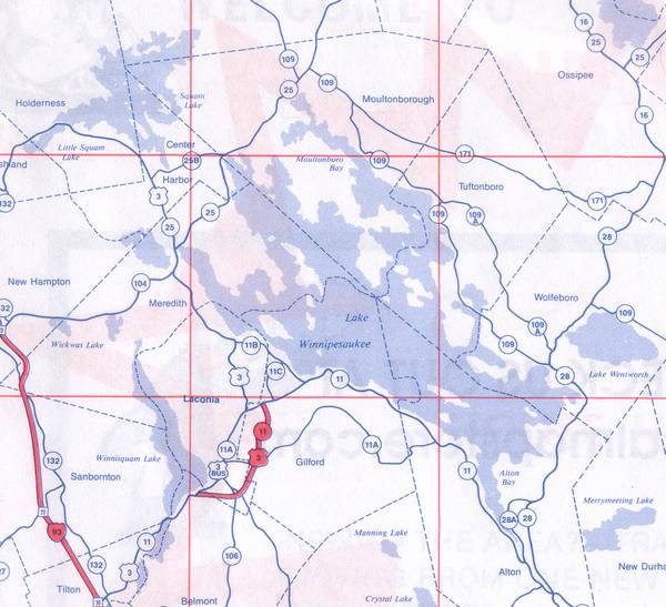
|
|
|
|
|
03-09-2005, 06:56 PM
|
#3 |
|
Senior Member

Join Date: Jul 2002
Location: Rock Haven Lake - West Newfield, ME
Posts: 5,361
Thanks: 374
Thanked 1,044 Times in 490 Posts
|
and very complicated but it goes something like this. Originally there was no Laconia. There was Meredith to the north of Paugus Bay (then called Long Bay maybe) and there was Gilmanton to the south. That's it. Gilford annexed itself from Gilmanton because it was too difficult for them to get to the Meeting Hall (church) because they had to go over the Belknap (then called Suncook) Mountains. That might have been in 1812. Meredith Bridge (Weirs and the north side of Lake Village=Lakeport) annexed itself from Meredith in 1855. Then, somewhere around 1893 parts of Gilford and Meredith annexed themselves away to form Laconia. Lakeport joined Laconia shortly thereafter with the promise of a sewerage system.
Now ...Governor's Island was annexed from ? (Meredith?) to Gilford in 1799. (There was no Gilford in 1799 so it must ahve been Gilmanton.) The islands were pretty inaccessible in those days. They were used only for timber and for pasture lands. There was no bridge to the island until 1807 and that was before the lake was raised by the Lakeport dam. The first real development on the island didn't take place until about 1885 when a granite mansion was built by Hutchins. It wasn't advertised for real estate development until about 1928. So, as I said, it is complicated. When the towns of Gilford and Laconia were making long range plans to secure monies to fund a high school, Governor's Island wasn't really on the radar screen.
__________________
|
|
|
|
|
03-10-2005, 09:06 AM
|
#4 |
|
Member

Join Date: Jan 2003
Location: Gilford-Northern MA
Posts: 38
Thanks: 3
Thanked 5 Times in 2 Posts
|
Great history lesson McDude!!! If I ever have a question about the lake I'm going straight to you!!!

__________________
Lakegirl Never leave home without your camera 
|
|
|
|
|
03-10-2005, 12:35 PM
|
#5 |
|
Senior Member

Join Date: Oct 2004
Location: Laconia NH
Posts: 5,512
Thanks: 3,118
Thanked 1,090 Times in 784 Posts
|
Back in those days Vermont was New Hampshire. Please welcome Killington back to the Granit State!
__________________
Someday may never be an actual day. |
|
|
|
| Sponsored Links |
|
|
|
03-10-2005, 12:47 PM
|
#6 |
|
Senior Member
|
Thanks for the reply, it's always interesting to know why things are the way they are.
Laconia looks like it has its' share of problems with its' infrastructure. Take a drive up & down Centenarian Drive in the Weirs area and you will be amazed at the rough condition of the paved road. "Rough Road" is what the city sign says. The new Akwa Soliel developement accesses its' marina & beach by crossing Centenarian Drive. Could be the City is hoping for the Akwa Soliel to help out with the Centarian Drive repair. It sure needs help....my my my....such a road....looks like an ad for a Jeep-up-on-top-of-the-mountain. Now, if this road had just been left alone as an unpaved dirt road, it would not be having all these frost heave problems. Paving a dirt road is not a panacea! Isn't that right? |
|
|
|
|
03-10-2005, 01:05 PM
|
#7 |
|
Senior Member

Join Date: Apr 2004
Location: Lakes Region
Posts: 547
Thanks: 9
Thanked 29 Times in 20 Posts
|
The rock formerly signifying the northern border of Massachusetts is right at the entrance to Paugus Bay (in the park by the bridge)..
|
|
|
|
|
03-10-2005, 07:38 PM
|
#8 |
|
Senior Member

Join Date: Sep 2003
Location: Gilmanton, NH
Posts: 754
Thanks: 136
Thanked 92 Times in 51 Posts
|
Half of Walmart is in Gilford and the other half in Laconia (don't know which aisle is the demarcation point). If I'm not mistaken, Laconia gets the property taxes, so it probably makes up for Govenor's Island
|
|
|
|
|
03-10-2005, 08:25 PM
|
#9 |
|
Senior Member
|
Boy, is that ever fascinating. Next time I'm there, I'll ask the Greeter at the entrance where that boundary is at and report back here. If New Hampshire ever gets a 4% sales tax, with half going to the local town and half going to the state, that boundary could make a differance.
From the Dept of Useless Information, an inquiring mind asks: Since the airport is located in Gilford, then why is it called the Laconia Airport? |
|
|
|
|
03-15-2005, 05:31 PM
|
#10 |
|
Junior Member

Join Date: Apr 2004
Posts: 8
Thanks: 0
Thanked 0 Times in 0 Posts
|
just thought some of you might like to take a look at the Governor's Island web site. It's pretty basic, but has some nice historic stuff. http://www.giclub.org/index.html
There was an article writen in the Weirs Times that talks about when it was Davis Island (at least I think it was Davis Island) Does anyone know where I could get a copy? |
|
|
|
|
03-15-2005, 06:47 PM
|
#11 |
|
Senior Member
Join Date: Nov 2003
Location: Central NH
Posts: 5,252
Blog Entries: 1
Thanks: 1,451
Thanked 1,349 Times in 475 Posts
|
Thanks for the Governor's link. The 1944 brochure was interesting, especially the aerial view.
You are correct. It was once called Davis Island. |
|
|
|
|
| Bookmarks |
|
|


 Linear Mode

