

|
|
|
|
|
|||||||
| Home | Forums | Gallery | Webcams | Blogs | YouTube Channel | Classifieds | Calendar | Register | FAQ | Donate | Members List | Today's Posts | Search |
 |
|
|
Thread Tools | Display Modes |
 05-02-2017, 07:40 AM
|
#1 |
|
Senior Member

Join Date: Oct 2004
Location: Laconia NH
Posts: 5,522
Thanks: 3,128
Thanked 1,090 Times in 784 Posts
|
This article hint of a 'no wake' situation this spring.
http://www.unionleader.com/environme...evels-05022017
__________________
Someday may never be an actual day. |

|

|
|
05-02-2017, 08:06 AM
|
#2 |
|
Senior Member
Join Date: Jun 2012
Location: Derry / Gilford
Posts: 1,238
Thanks: 70
Thanked 344 Times in 234 Posts
|
This past weekend I noticed the lake was down an inch or so from the previous weekend, for whatever that is worth (probably nothing)

__________________
Don't listen to me, obviously I don't understand what I'm talking about! Let's help each other save time and money: WinniGas.com |
|
|
|
| The Following User Says Thank You to Rich For This Useful Post: | ||
DBreskin (05-02-2017) | ||
|
05-02-2017, 08:09 AM
|
#3 |
|
Senior Member

Join Date: Apr 2016
Location: In the hills
Posts: 2,357
Thanks: 1,603
Thanked 766 Times in 460 Posts
|
I don't know why they have to let so much damned water out of Winni...the rivers downstream are raging and dollars to donuts we'll experience a low water situation like last year. Keep the lake full dammit! Just my opinion,of course...
|
|
|
|
|
05-02-2017, 08:49 AM
|
#4 |
|
Senior Member
Join Date: May 2006
Location: Long Island, not that one, the one on Winnipesaukee
Posts: 2,836
Thanks: 1,019
Thanked 884 Times in 517 Posts
|
With my dock now in the water, I have my guage.. While the water is high, it still can come up another 3 to 4 inches.... At that point in the past is generally when Winnipesaukee has gone No Wake..... We just have to see how much rain May brings with it.
As for HillCountry's statement.... While it would be nice for DES to let the lake fill more, most private shore fronts, and even some Marina's are not built to handle to much more water then 504.5 ft above see level.... In short once the lake goes above that level, DES starts to get complaints.....
__________________
Life is about how much time you can spend relaxing... I do it on an island that isn't really an island..... |
|
|
|
|
05-02-2017, 10:20 AM
|
#5 |
|
Senior Member

Join Date: Feb 2004
Location: Center Harbor
Posts: 1,140
Thanks: 202
Thanked 424 Times in 242 Posts
|
The lake level has gone above the full lake level and the Lakeport output has been gradually increased since mid April to keep it from going much higher. The next 10 days is looking very rainy so that seems like a smart policy for now.
The lake level management is more art than science. A couple heavy rainfalls and the lake level goes soaring up. You can't open the dam much more at that time because the runoff from the rain is already causing high levels downstream. It can take weeks to get the levels back down. The low levels last fall were unusual because of the drought caused lack of rain. Overall, somewhat low lake levels are annoying but manageable. Levels above full lake cause lots of problems. Overall the dam management folks do a great job but they are at the mercy of unusually wet or dry weather just like the rest of us. |
|
|
|
| The Following 9 Users Say Thank You to jeffk For This Useful Post: | ||
Blyblvrd (05-03-2017), Dad sold the C * C (05-02-2017), Descant (05-02-2017), Hillcountry (05-02-2017), joey2665 (05-02-2017), loonguy (05-04-2017), MRD (05-02-2017), Top-Water (05-03-2017), Wiezy (05-02-2017) | ||
| Sponsored Links |
|
|
|
05-02-2017, 04:36 PM
|
#6 | |
|
Senior Member
Join Date: Apr 2016
Location: In the hills
Posts: 2,357
Thanks: 1,603
Thanked 766 Times in 460 Posts
|
Quote:
So, if you can please enlighten us less knowledgeable lake users on how levels above full lake can cause lots of problems, what, exactly, are the problems? I can visualize water levels ABOVE dock surfaces would be a problem but that would have to be quite a bit higher than "full lake" so what other problems can occur? |
|
|
|
|
|
05-02-2017, 05:22 PM
|
#7 | |
|
Senior Member

Join Date: Apr 2004
Location: Kuna ID
Posts: 2,755
Thanks: 246
Thanked 1,942 Times in 802 Posts
|
Quote:
Go over to Sheps, part of their docks are under water as well as part of the town dock there. Dock levels are relative and probably why full lake is determined by a more precise measurement - as compared to sea level. Far as any additional problems, clearly shoreline erosion is the biggest concern once you see water levels exceed the natural exposed rock along the shores that protect the soils that are behind them. |
|
|
|
|
| The Following User Says Thank You to MAXUM For This Useful Post: | ||
Hillcountry (05-02-2017) | ||
|
05-02-2017, 05:41 PM
|
#8 | |
|
Senior Member
Join Date: Feb 2005
Location: Gilford, NH and Florida
Posts: 2,916
Thanks: 651
Thanked 2,164 Times in 906 Posts
|
Quote:
Docks that work well to handle boats at a certain height can damage boats when the rub rail is above the posts. If you look at some of the cottages on Paugus Bay along Weirs Boulevard near Christmas Island you will see that they do not have a lot of room to work with before high water will damage them. There are many low bridges (Alton, Wolfeboro to name two) and high water prevents some boats from transiting those channels. When the water is very high it is difficult for some of the large boats to exit Silver Sands Marina under the island bridge. |
|
|
|
|
|
05-02-2017, 07:46 PM
|
#9 | |
|
Senior Member
Join Date: Feb 2003
Location: Moultonboro, NH
Posts: 1,658
Blog Entries: 1
Thanks: 344
Thanked 620 Times in 279 Posts
|
Quote:
__________________
-lg |
|
|
|
|
|
05-03-2017, 04:52 AM
|
#10 | |
|
Senior Member
Join Date: Feb 2004
Location: Center Harbor
Posts: 1,140
Thanks: 202
Thanked 424 Times in 242 Posts
|
Quote:
|
|
|
|
|
| The Following User Says Thank You to jeffk For This Useful Post: | ||
Top-Water (05-03-2017) | ||
|
05-04-2017, 06:30 AM
|
#11 |
|
Senior Member
Join Date: Feb 2003
Location: Moultonboro, NH
Posts: 1,658
Blog Entries: 1
Thanks: 344
Thanked 620 Times in 279 Posts
|
This morning, the lake is at 504.40, almost an inch over a full lake level of 504.32. There is no statute mandating a lake wide no-wake zone, but in my opinion, it should be set to 505.00, a seven inch flood. That would honor the recreation and economic needs, yet put a cap on damage to lake health. I don't think anything lower would win approval. According to Bizer's lake level charts, the level has only gone above 505 feet three (almost four) times since 2000.
It has been years since the area flooded and Winnipesaukee water quality measures better than five years ago. Clarity is better and phosphorus (plant food) level is lower. I hope we don't get an opportunity to measure its decline. We are a unusually heavy rain and a sunny warm weekend away from that happening. If you are interested in water quality, the best organizations to get involved with are Lake Winnipesaukee Association (local management) and NH Lakes Association (state wide legislation).
__________________
-lg |
|
|
|
| The Following 3 Users Say Thank You to Lakegeezer For This Useful Post: | ||
|
05-05-2017, 03:39 PM
|
#12 |
|
Senior Member

Join Date: May 2005
Location: Isola Gatto Nero
Posts: 696
Thanks: 162
Thanked 263 Times in 81 Posts
|
The only time I remember they mandated a lake wide no wake was on or around July 4th in 1998. What was the level at then?
__________________
La vita è buona su Isola Gatto Nero |
|
|
|
|
05-05-2017, 04:32 PM
|
#13 |
|
Senior Member
Join Date: Jun 2009
Posts: 230
Thanks: 21
Thanked 119 Times in 54 Posts
|
Lakegeezer, you mention water quality has improved the last few years. i was unaware of that but its certainly great news.
When there is a lot of rain or melt does that flush the lake (a good thing) or does the runoff bring the phosphorus, salt.... into the lake (a bad thing)? |
|
|
|
|
05-05-2017, 08:43 PM
|
#14 |
|
Senior Member
Join Date: Mar 2006
Location: Merrimack and Welch Island
Posts: 4,079
Thanks: 1,232
Thanked 1,534 Times in 992 Posts
|
Stormwater runoff creates problems all around the state. There are recent rules (last 5-10 years) to better control this, but we still have, for example, too much salt on our roads. The folks who minimize phosphorus on lawns, may still salt their driveways and adjacent roads. Whatever your chemical preference, vegetation or distance from the lake or some other water body, it all still runs downhill. Could be salt, fertilizer, animal droppings, PFOA or MtBE. It all goes down gradient.
|
|
|
|
|
05-08-2017, 05:46 AM
|
#15 |
|
Senior Member
Join Date: Nov 2016
Location: Waltham Ma./Meredith NH
Posts: 3,784
Thanks: 1,996
Thanked 1,075 Times in 680 Posts
|
Still and stagnant water brings its own set of problems, as the drought situation we had last season. That will also negatively affect water quality.
|
|
|
|
|
05-08-2017, 06:20 AM
|
#16 | |
|
Senior Member
Join Date: Feb 2005
Location: Gilford, NH and Florida
Posts: 2,916
Thanks: 651
Thanked 2,164 Times in 906 Posts
|
Quote:
|
|
|
|
|
|
05-08-2017, 06:44 AM
|
#17 |
|
Senior Member

Join Date: Mar 2003
Location: FL, Bear Is.
Posts: 178
Thanks: 43
Thanked 67 Times in 39 Posts
|
Here is Bizer's lake level chart from a decade ago. I estimate the peak of the 1998 flood was just over 14 inches above full lake, and down to about a foot for July 4.
Chart does also show the severity of the 1984 high lake level. Last edited by Bear Guy; 05-18-2017 at 01:09 PM. |
|
|
|
|
05-17-2017, 10:59 AM
|
#18 |
|
Senior Member

Join Date: Jun 2009
Posts: 84
Thanks: 16
Thanked 18 Times in 11 Posts
|
http://www.des.nh.gov/organization/d.../winni_levels/
We are watching this daily as we have some work to do on our dock and the supports are under water - tough to use the power tools! |
|
|
|
|
05-17-2017, 12:00 PM
|
#19 | |
|
Senior Member
Join Date: Feb 2008
Location: Gilford, NH / Welch Island
Posts: 5,973
Thanks: 2,303
Thanked 4,984 Times in 1,931 Posts
|
Quote:
Dan
__________________
It's Always Sunny On Welch Island!! 
|
|
|
|
|
|
05-17-2017, 02:16 PM
|
#20 |
|
Senior Member

Join Date: Jul 2005
Location: Berlin, Ma / Gilford
Posts: 1,931
Thanks: 445
Thanked 604 Times in 340 Posts
|
That's actually interesting and probably a result of all the rain Sunday & Monday past ..... I actually made note to look under the bridge on Saturday (mid-day) and was somewhat surprised to see that the Lake was actually at Full Lake (red line just peeking above the waterline) -- I sort of expected to see an inch or two above the Red Line.
.
__________________
A bad day on the Big Lake (although I've never had one) - Still beats a day at the office!! |
|
|
|
|
05-17-2017, 09:26 PM
|
#21 |
|
Junior Member
Join Date: May 2017
Posts: 1
Thanks: 0
Thanked 0 Times in 0 Posts
|
"Full LAKE" since the 80's is at least 10" higher than all the time prior. Been on the island for over 4 decades. In 1984 worst flooding in recorded history. Docks that were functional and dry for nearly a century are IN the lake every 3-4 years on average now.
Why don't they show average lake levels over the last 75 years? In the last 20 years high water levels have caused erosion, dock and other real problems 6 times! Nubies on the lake have docks built to new full LAKE levels and weekend boaters don't have problems. No so for us who built prior to 1984. I have lost 4-7 feet of shoreline soil since 1990 despite re-rocking shoreline numerous times. I know it is a difficult job when electrical generation is the major factor in keeping the lake high. Wish they would lower lake so that a 2 inch rain forcasted 7-10 day before doesn't cause problems. Seems they manage the levels re-actively rather than pro-activley. Need a lower "safety net" level ALL year. P.S. If lowering water level 10" more is going to damage props (as some use as excuse for full lake) then you are going too fast, don't have a chart or local knowledge or you are in the wrong area. |
|
|
|
|
05-18-2017, 06:04 AM
|
#22 | |
|
Senior Member
Join Date: Nov 2016
Location: Waltham Ma./Meredith NH
Posts: 3,784
Thanks: 1,996
Thanked 1,075 Times in 680 Posts
|
Quote:
|
|
|
|
|
|
05-18-2017, 07:56 AM
|
#23 |
|
Senior Member
Join Date: Feb 2008
Location: Gilford, NH / Welch Island
Posts: 5,973
Thanks: 2,303
Thanked 4,984 Times in 1,931 Posts
|
This is probably the best article I have read which explains the reasoning behind full lake and fall draw down and the science behind it. DES has their hands full maintaining the lake at a proper level and I think they do a great job for the most part!
http://nhpr.org/post/maintaining-lev...nment#stream/0 Dan
__________________
It's Always Sunny On Welch Island!!
|
|
|
|
|
05-18-2017, 10:53 AM
|
#24 | |
|
Senior Member
Join Date: Jun 2009
Posts: 84
Thanks: 16
Thanked 18 Times in 11 Posts
|
Quote:
 I am well aware of lake levels and how they fluctuate throughout the season... but thanks for letting me know about September. That was super helpful.  I now know why I have been a member of this board for years but rarely offer a comment. I was simply showing users how to get up to the date numbers on the lake level. Happy Summer and as they say in the South - Bless Your Heart! |
|
|
|
|
|
05-18-2017, 11:54 AM
|
#25 |
|
Senior Member

Join Date: Apr 2004
Posts: 5,075
Thanks: 215
Thanked 903 Times in 509 Posts
|
Dont understand the sarcasm towards Dan. Always very informative and never out of line. I didnt sense his post was an attack on you rather that the lake is pretty near normal and your issue would be the same most years.
__________________
SIKSUKR |
|
|
|
|
05-18-2017, 12:06 PM
|
#26 | |
|
Senior Member
Join Date: Nov 2016
Location: Waltham Ma./Meredith NH
Posts: 3,784
Thanks: 1,996
Thanked 1,075 Times in 680 Posts
|
Quote:

Last edited by Biggd; 05-18-2017 at 12:41 PM. |
|
|
|
|
|
05-18-2017, 12:16 PM
|
#27 | |
|
Senior Member
Join Date: Feb 2008
Location: Gilford, NH / Welch Island
Posts: 5,973
Thanks: 2,303
Thanked 4,984 Times in 1,931 Posts
|
Quote:
Since you rarely post here I didn't know you were "well aware of how the lake fluctuates" and why I mentioned September....Many who come here are looking for information and I was just trying to pass that on... Thanks for the blessing on my heart though, it needs all the help it can get! Dan
__________________
It's Always Sunny On Welch Island!!
|
|
|
|
|
|
05-18-2017, 01:14 PM
|
#28 | |
|
Senior Member
Join Date: Jun 2009
Posts: 84
Thanks: 16
Thanked 18 Times in 11 Posts
|
Quote:

|
|
|
|
|
|
05-18-2017, 01:17 PM
|
#29 | |
|
Senior Member
Join Date: Jun 2009
Posts: 84
Thanks: 16
Thanked 18 Times in 11 Posts
|
Quote:
Have a great Summer - I promise never to be sarcastic again.
|
|
|
|
|
|
05-18-2017, 02:04 PM
|
#30 |
|
Senior Member
Join Date: May 2004
Posts: 962
Thanks: 495
Thanked 273 Times in 174 Posts
|
The gauge on our dock post on East Bear Island indicates that the lake is about six inches below pool (full) elevation. 🐻
|
|
|
|
|
05-18-2017, 02:40 PM
|
#31 | |
|
Senior Member
Join Date: Mar 2006
Location: Merrimack and Welch Island
Posts: 4,079
Thanks: 1,232
Thanked 1,534 Times in 992 Posts
|
Quote:
I'm curious about your location to lose that much shore and to have your dock so low. The docks at my marina (early 1960's construction) would stand up well if the lake were another foot higher. Same for many docks I'm familiar with from similar construction period. Do your neighbors also have "low" docks? |
|
|
|
|
|
05-18-2017, 02:45 PM
|
#32 | |
|
Senior Member

Join Date: Feb 2016
Location: Sandown/Gilford
Posts: 189
Thanks: 80
Thanked 67 Times in 26 Posts
|
Quote:
__________________
Captain of the "Day Tripper II" .......There are a lot better people a lot worse off!! |
|
|
|
|
|
05-18-2017, 06:43 PM
|
#33 | |
|
Senior Member
Join Date: Feb 2005
Location: Gilford, NH and Florida
Posts: 2,916
Thanks: 651
Thanked 2,164 Times in 906 Posts
|
Quote:
|
|
|
|
|
|
05-18-2017, 07:06 PM
|
#34 |
|
Senior Member
Join Date: May 2004
Posts: 962
Thanks: 495
Thanked 273 Times in 174 Posts
|
Downhill. 🐻 Oops, You are correct.......strong east wind pushes the water towards the Weirs.
Last edited by Barney Bear; 05-19-2017 at 05:48 AM. |
|
|
|
|
05-19-2017, 08:48 AM
|
#35 |
|
Senior Member
Join Date: May 2004
Posts: 962
Thanks: 495
Thanked 273 Times in 174 Posts
|
Checked our dock post gauge (a pair of nails) this morning. Lake level appears to be several inches above pool. My earlier reading was wrong. Looking forward to eating crow. 🍷
|
|
|
|
|
05-19-2017, 04:05 PM
|
#36 |
|
Senior Member
Join Date: Feb 2015
Posts: 817
Thanks: 113
Thanked 204 Times in 127 Posts
|
Isn't it interesting to be discussing "FULL" lake level when last fall the discussion was about "LOW" lake levels....And The MV Mt Sunapee running aground.
Mother Nature sure is fickle and the DES has a tough job keeping up with her. https://www.winnipesaukee.com/forums...highlight=lake |
|
|
|
|
05-20-2017, 07:18 AM
|
#37 |
|
Senior Member
Join Date: Nov 2016
Location: Waltham Ma./Meredith NH
Posts: 3,784
Thanks: 1,996
Thanked 1,075 Times in 680 Posts
|
All I know is my prop should make it through at least half the summer season in pristine condition.

|
|
|
|
|
05-20-2017, 08:14 AM
|
#38 | |
|
Senior Member
Join Date: Sep 2008
Location: Meredith Bay & LI, NY
Posts: 3,220
Thanks: 1,209
Thanked 1,007 Times in 648 Posts
|
Quote:
Now that is funny!!! Sent from my iPhone using Winnipesaukee Forum mobile app |
|
|
|
|
|
05-27-2017, 10:42 AM
|
#39 | |
|
Senior Member

Join Date: Jan 2005
Location: Florida (Sebring & Keys), Wolfeboro
Posts: 5,800
Thanks: 2,090
Thanked 745 Times in 534 Posts
|
Quote:
 That I can recall, I've lost three trees in this undeveloped stretch of shoreline. One was huge, but the smaller trees "leaning" today suggest that erosion has increased in intensity. Several of my trees that had formerly grown straight, have started "that lean" towards the lake.   'Course, my neighbor has it worse! 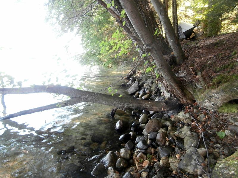 Taken earlier in Spring, this photo shows the leaning trees without the cover of new growth: .
__________________
Every MP who enters Winter Harbor will pass by my porch of 67 years... 
Last edited by ApS; 06-03-2017 at 08:33 PM. |
|
|
|
|
|
| Bookmarks |
|
|


 Linear Mode

