

|
|
|
|
|
|||||||
| Home | Forums | Gallery | Webcams | Blogs | YouTube Channel | Classifieds | Calendar | Register | FAQ | Donate | Members List | Today's Posts | Search |
|
|
Thread Tools | Display Modes |
 03-15-2005, 01:44 PM
|
#1 |
|
Senior Member

Join Date: Nov 2003
Location: Central NH
Posts: 5,252
Blog Entries: 1
Thanks: 1,447
Thanked 1,349 Times in 475 Posts
|
Picked up photo copies of this map at the Tuck Library
Sewed it together and cleaned it up. Full Size Map 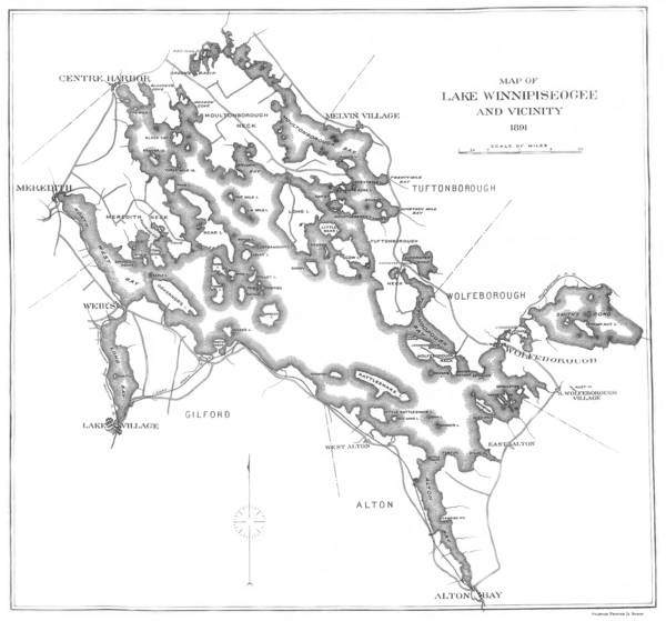 Note the different names to familiar places. Meredith Bay = Northwest Bay Paugus Bay = Long Bay Big Island = Goat Island (On my other old map it is Boat Island) Varney Point = Smith Neck Round Island = Smith Island Camp Island = Folley's Island Sleepers Island = Little Rattlesnake Island Moose Island = Varney's Island Treasure Island = Red Head Island Black Point = Fort Point Echo Point = Gerrish Point Barndoor Island = Keniston Island Lake Wentworth = Smith's Pond Mirror Lake = Dishwater Pond |

|

|
| The Following 3 Users Say Thank You to Rattlesnake Gal For This Useful Post: | ||
| Bookmarks |
|
|


 Threaded Mode