

|
|
|
|
|
|||||||
| Home | Forums | Gallery | Webcams | Blogs | YouTube Channel | Classifieds | Calendar | Register | FAQ | Donate | Members List | Search | Today's Posts | Mark Forums Read |
 |
|
|
Thread Tools | Display Modes |
 09-01-2006, 07:51 PM
|
#1 |
|
Junior Member
Join Date: Aug 2006
Posts: 17
Thanks: 0
Thanked 0 Times in 0 Posts
|
How do I get to it? Anybody have any pictures or a link to pictures?
|

|

|
|
09-02-2006, 08:38 AM
|
#2 |
|
Senior Member

Join Date: Mar 2003
Location: Merrymeeting Lake, New Durham
Posts: 2,217
Thanks: 299
Thanked 795 Times in 365 Posts
|
I'm not sure if there is a way to get there from Rt. 28. We always go from the Merrymeeting side.
Starting at the Rt. 11 Alton Circle follow signs for Merrymeeting Lake (the road just to the right of McDonald's). When you get to the NH Fish Hatchery and the dam, take a left onto Merrymeeting Road. You will go past the Merrymeeting Market and Marina. Follow road for approximately 2 miles (guesstimate). The road takes a sharp right turn and becomes North Shore Road at that point. Here at the start of N. Shore Rd, a dirt road branches off to the left. This is the road that leads to Devil's Den. You can drive in part of the way, but at some point the road degrades and you will need to park and go the rest of the way on foot. http://www.mapquest.com/maps/map.adp...3d&ambiguity=1 I haven't been up there for several years so perhaps someone else can take over from here. But if you get this far, there is usually someone nearby whom you can ask to point you to the start of the trail. |
|
|
|
|
09-03-2006, 03:14 PM
|
#3 |
|
Senior Member

Join Date: Apr 2004
Posts: 295
Thanks: 74
Thanked 52 Times in 25 Posts
|
Is ther anyone who can tell me what this is?
|
|
|
|
|
09-03-2006, 05:00 PM
|
#4 |
|
Senior Member
Join Date: Jul 2005
Posts: 262
Thanks: 0
Thanked 23 Times in 11 Posts
|
It's a really nice hike, to a summit with great views, and a natural cave for climbing through. It's a great way to spend an afternoon.
|
|
|
|
|
09-06-2006, 08:39 PM
|
#5 |
|
Senior Member
Join Date: Jul 2005
Posts: 262
Thanks: 0
Thanked 23 Times in 11 Posts
|
We were there two summers ago, and there was a ladder there.
|
|
|
|
| Sponsored Links |
|
|
|
09-06-2006, 08:42 PM
|
#6 |
|
Senior Member
Join Date: Mar 2003
Location: Merrymeeting Lake, New Durham
Posts: 2,217
Thanks: 299
Thanked 795 Times in 365 Posts
|
Yankee,
Thanks for the additional info. As of 2 summers ago, the ladder was still there, but it was in rough shape. |
|
|
|
|
09-07-2006, 07:25 AM
|
#7 | |
|
Senior Member

Join Date: Jul 2002
Location: Rock Haven Lake - West Newfield, ME
Posts: 5,359
Thanks: 374
Thanked 1,041 Times in 489 Posts
|
From "Back Porch Tales" by Karl M. Frost - 1974 - pp. 25-26
Quote:
|
|
|
|
|
|
09-07-2006, 11:01 AM
|
#8 |
|
Member
Join Date: Jul 2006
Location: diamond island
Posts: 23
Thanks: 1
Thanked 3 Times in 2 Posts
|
does any one have the lat/lon coordinates so i can put it in my gps?
thanks, A.Mekler |
|
|
|
|
09-11-2006, 10:58 AM
|
#9 |
|
Junior Member
Join Date: Aug 2006
Posts: 17
Thanks: 0
Thanked 0 Times in 0 Posts
|
All of the information posted so far is great and is only making more interested in wanting to visit the den. Need someone to post EXACT description of how to get to the darn thing.
|
|
|
|
|
09-11-2006, 05:02 PM
|
#10 | |
|
Senior Member
Join Date: Jul 2002
Location: Rock Haven Lake - West Newfield, ME
Posts: 5,359
Thanks: 374
Thanked 1,041 Times in 489 Posts
|
Quote:
 people I've given directions to have informed me it is West not North as I always thought!) on Rt. 11 towards Alton? people I've given directions to have informed me it is West not North as I always thought!) on Rt. 11 towards Alton?Dot's Lunch... Mamarina's... New Durham Station.. ....and now....Johnson's Steak and Seafood. (and ice cream!) 
|
|
|
|
|
|
09-14-2006, 10:21 AM
|
#11 |
|
Junior Member
Join Date: Aug 2006
Location: East Alton
Posts: 4
Thanks: 0
Thanked 0 Times in 0 Posts
|
My home is in the shadows of Devils Den. To get there from Rt28, go east on Rines Rd. App 1.4 mi. crossing Beaver Brook and thru seasonal gate. This section of Rines rd. is part of the Powder Mill Snowmobile Trail System.
Take 2nd rt (A large open trail junction with many orange trail signs). At next junction (more signs), go right again, you should be going in a south west direction winding thru dense woods. Approx 2mi you will come to another trail junction. Go right thru a steel green gate. devils den will be appr 200 yds on left (LOOK UP). There will be places to pull in to park. These roads are rough in places, but a road car will make it. I recommend an SUV or other off-road vehicle. The cave ladder is still there but missing a few rungs. Be careful...Have fun.. Hillbilly |
|
|
|
|
09-27-2007, 04:52 PM
|
#12 | |
|
Senior Member
Join Date: Jul 2002
Location: Rock Haven Lake - West Newfield, ME
Posts: 5,359
Thanks: 374
Thanked 1,041 Times in 489 Posts
|
I just had to add this photo taken from devil's den and posted on the gallery today by dcr
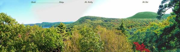 Here's his commentary... Quote:
|
|
|
|
|
|
10-03-2007, 07:15 AM
|
#13 |
|
Deceased Member
Join Date: Feb 2004
Posts: 1,317
Thanks: 0
Thanked 1 Time in 1 Post
|
I just noticed the inquiry about the "precise" location of the Devil's Den on Devils Den Mt. I happened to have revisited that site yesterday for the first time in decades - I used to hike to it often long ago when I was a kid who spent summers at the family camp on Merrymeeting Lake. Finding Devils Den Mt is the first step and that should be fairly easy if you have access to a good Atlas - the old roads leading in to the mountain are best traveled by a 4-wheel drive vehicle, but one can drive a car in to within a mile or two of the mountain before having to hike the rest of the way. A recent poster identified what is probably the easiest way in, starting with the Rines Rd off Rte 28 in Alton, close to the Wolfeboro line. Finding the summit, only a short walk off the 'Devils Den Rd' at the top of a small ridge, is not very hard - however, the den itself is not particularly close to the summit, probably 2 to 3 hundred yards down the ENE side of the mountain. A number of paths lead from the summit in that general direction - using the coordinates 43-30.8 N, 71-10.3 W might be some help, but be advised that those are rough numbers, taken from my mapping program and my best guess of where on the map the cave is located - they are not coordinates taken at the actual cave site with a GPS unit. Walk one (or more, if necessary) of the paths which lead generally ENE, going steadily downhill - you will probably come upon some high, steep vertical cliffs, which the paths should lead you north or south to get around to more favorable sites to continue your descent. The first part of the cave you are apt to see is the exit hole coming out atop one of those sections of steep cliff. From there you should be able to find a path(s) leading downhill still further, soon leading you to the cave entrance, which you will have to climb back up a small ways to get to. I hope this rather rambling description can prove to be of some help rather than simply causing more confusion.
Last edited by dcr; 10-03-2007 at 04:09 PM. |
|
|
|
|
| Bookmarks |
| Thread Tools | |
| Display Modes | |
|
|


 Linear Mode

