

|
|
|
|
|
|||||||
| Home | Forums | Gallery | Webcams | Blogs | YouTube Channel | Classifieds | Calendar | Register | FAQ | Donate | Members List | Today's Posts | Search |
 |
|
|
Thread Tools | Display Modes |
 05-22-2006, 08:50 PM
|
#1 |
|
Senior Member

Join Date: Apr 2004
Location: Westford, MA and Alton Bay, NH
Posts: 225
Thanks: 0
Thanked 0 Times in 0 Posts
|
Can anyone that is living on the lake everyday let us know how things are going?
Has the level dropped at all? I know when I was at our house on Saturday and Sunday it was pretty dismal!! Just to see the amount of damage and docks underwater..... and I thought the floods in October were bad. That was nothing compared to this. Anyway, if someone can keep us informed, I for one would be greatly appreciative!
__________________
Wendy "Wasn't Me!" |

|

|
|
05-23-2006, 06:11 AM
|
#2 |
|
Senior Member

Join Date: Feb 2006
Location: NH Seacoast and Smith's Cove
Posts: 58
Thanks: 20
Thanked 2 Times in 2 Posts
|
We visited our boat at Fays yesterday and talked with other boaters. The boat was safe but the our pier had about 6 inches of water over it.
We were told that it'll be at least 2 weeks before things get back to normal boating conditions. Based on putting nails into pier posts at the water level and then watching the water level, some people said the Lake has risen this week. While driving we saw many piers under water and no boats on the water.
__________________
Many men go fishing all of their lives without knowing that it is not fish they are after. ~Henry David Thoreau Last edited by RamJet; 05-23-2006 at 08:53 PM. |
|
|
|
|
05-23-2006, 07:11 AM
|
#3 |
|
Senior Member

Join Date: May 2005
Location: Isola Gatto Nero
Posts: 696
Thanks: 162
Thanked 263 Times in 81 Posts
|
The level is pretty much the same as it was when you were here on Sunday. You can track it yourself from this DES web site.
http://www.des.state.nh.us/rti_data/wein3_TABLE.HTML
__________________
La vita è buona su Isola Gatto Nero |
|
|
|
|
05-23-2006, 08:37 AM
|
#4 |
|
Senior Member

Join Date: Jan 2006
Location: West Alton, NH
Posts: 169
Thanks: 0
Thanked 25 Times in 11 Posts
|
As a full time resident, I'll tell you what I have seen. Yesterday was a bad day for those with an exposure to the northwest winds. The winds blew at 25-35 mph from Sunday night until some time last night. Right now they are blowing at 18 mph. Our shoreline is mostly large rocks that have been there since the glaciers left and covered with wild lowbush blueberries. The area that does not have the larger rocks took a real beating. The waves were large and debris went over our dock all day long. We did what we could to protect the shoreline and the root system of a very large pine tree at the waters edge. The level of the lake seems to be staying about the same. The dam outflow is probably equaling the inflow from the streams.
People with lawns, plantings and beaches at the waters edge will see significant damage. I'm very glad we have old rocks and blueberries, with their very tenacious root system.
__________________
QL (Doing my best to encourage Global Warming ... one quilt at a time!) |
|
|
|
|
05-23-2006, 08:43 AM
|
#5 |
|
Member
Join Date: Apr 2004
Posts: 23
Thanks: 0
Thanked 8 Times in 1 Post
|
From what seen on DES website(s) the lake is holding firm even with the high discharge from Lakeport. Inflows are still exceeding outflow (dam). It's not hard to figure that even without any rain the high water will remain for week(s). I would not be surprised to see July 4th with high water levels based upon improvements (none) over the past 10 days....
General forecast, RAIN followed by WIND with a chance of SUN.... 
|
|
|
|
| Sponsored Links |
|
|
|
05-23-2006, 12:27 PM
|
#6 |
|
Senior Member

Join Date: Mar 2003
Location: Merrymeeting Lake, New Durham
Posts: 2,217
Thanks: 299
Thanked 795 Times in 365 Posts
|
Yes, it will be weeks. Elsewhere on the site, someone provided the rough calculation that even at full discharge, the best that can be expected is that it receeds by 1"/day. So, rough numbers, about 6"/week.
So it would take ~3 weeks to lower it by 1.5 feet to get it back to normal. This assumes no more rain. Unlikely. Merrymeeting Lake has the same issues, and the outflow at the dam is maximized....flowing into Winnipesaukee. Similarly, the springs and streams that feed Merrymeeting are flowing at all time highs. The good news is that things seem to have stabilized and we are starting to see a minor but encouraging drop. If we can keep major rain away for awhile and allow the ground to dry out, we should be back to normal in about 3 weeks. |
|
|
|
|
05-23-2006, 12:46 PM
|
#7 |
|
Senior Member

Join Date: Feb 2003
Location: Cow Island
Posts: 914
Thanks: 602
Thanked 193 Times in 91 Posts
|
The numbers below are pretty much confirmed by Bizer's historic data (graph). In 1998 it took the first two weeks of July to drop a foot from that record high at the beginning of July.
|
|
|
|
|
05-23-2006, 06:48 PM
|
#8 |
|
Senior Member

Join Date: Jul 2002
Location: Central MA
Posts: 2,352
Thanks: 18
Thanked 535 Times in 179 Posts
|
The lake will also evaporate... but I have no idea how long it takes to lower it 1" at what humidity... anyone? anyone?
IG
__________________
Island Girl ....... Make Lemonade |
|
|
|
|
05-23-2006, 09:22 PM
|
#9 | |
|
Senior Member

Join Date: Sep 2003
Posts: 1,943
Thanks: 23
Thanked 111 Times in 51 Posts
|
Quote:
 The calculation is so full of crude estimates and averages that I wouldn't place much confidence in it being representative of the lake right now but .... FWIW it seems that NH has an annual average pan rate of 33"/year or 0.09"/day. According to the reference lakes evaporate at 70% of the rate the measurement pans do, so that gives us 0.063"/day or about 15.8 days to evaporate an inch. Funny, "Mee" asked the same question this weekend. When I get some time this weekend I'll see if I can't get a better estimate for this time of year (just for giggles). The calculation is so full of crude estimates and averages that I wouldn't place much confidence in it being representative of the lake right now but .... FWIW it seems that NH has an annual average pan rate of 33"/year or 0.09"/day. According to the reference lakes evaporate at 70% of the rate the measurement pans do, so that gives us 0.063"/day or about 15.8 days to evaporate an inch. Funny, "Mee" asked the same question this weekend. When I get some time this weekend I'll see if I can't get a better estimate for this time of year (just for giggles).
__________________
Mee'n'Mac "Never attribute to malice that which can be explained by simple stupidity or ignorance. The latter are a lot more common than the former." - RAH |
|
|
|
|
|
05-24-2006, 06:00 AM
|
#10 |
|
Senior Member
Join Date: Feb 2003
Location: Moultonboro, NH
Posts: 1,657
Blog Entries: 1
Thanks: 342
Thanked 618 Times in 278 Posts
|
The state web site which shows the lake level at the Weirs hasn't indicated much drop in the last few days, but that doesn't tell the whole story. In the calm water of this morning, the lake level is 1/2" lower at my dock than it was a few days ago. Another data point can be seen on the Pine Island cam. The dock in the picture is a bit more out of the water than it was, and is actually drying off a bit. Why is the sensor not showing the drop? Perhaps the constriction of the Weirs channel, and the fast flow through it, is causing the water to back up at the sensor, so it reads high.
__________________
-lg |
|
|
|
|
05-24-2006, 06:20 AM
|
#11 | ||
|
Senior Member

Join Date: Jan 2005
Location: Florida (Sebring & Keys), Wolfeboro
Posts: 5,788
Thanks: 2,085
Thanked 742 Times in 532 Posts
|
Quote:
Quote:
|
||

|
|
|
05-24-2006, 07:51 AM
|
#12 |
|
Senior Member
Join Date: Feb 2003
Location: Cow Island
Posts: 914
Thanks: 602
Thanked 193 Times in 91 Posts
|
I think Lakegeezer is likely on to something. The Wiers Channel bottleneck likely kept the sensor from recording the true peaks in the main lake. It only records the water level in Paugus Bay. I did see a 1/2" to 1" drop at my dock on Cow Island while the sensor showed no change.
With regard to trying to figure out how fast it can drop and evaporation rates et al, I tried that a while back and gave up due to too many variables. The best indication is available on Bizers level charts. If you want to know best case, look for the steepest slope curve. It appears that during the 1984 and 1998 peaks, we got the best lake drop rate after, at about 6" per week. Don't know what the rain, wind, or temp conditions were that contributed to that, but that appears to be "best" case. |
|
|
|
|
05-24-2006, 09:54 AM
|
#13 |
|
Senior Member

Join Date: Apr 2004
Posts: 5,075
Thanks: 215
Thanked 903 Times in 509 Posts
|
There is a definate constriction at the Weirs.The channel was running pretty fast on Sunday.Has anyone had problems heading downstream and maintaining steerage while heading to Paugus bay?
__________________
SIKSUKR |
|
|
|
|
05-24-2006, 11:31 AM
|
#14 |
|
Senior Member
Join Date: Feb 2003
Location: Cow Island
Posts: 914
Thanks: 602
Thanked 193 Times in 91 Posts
|
I wonder if anyone can determine what the drop is between the two ends of the Weirs channel? I'm sure it's computable based on width, length, avg. depth, and current speed. Any river runners out there? Anyone float through with a GPS to get a current speed?
|
|
|
|
|
05-25-2006, 02:02 PM
|
#15 |
|
Senior Member

Join Date: Jul 2002
Location: Massachusetts
Posts: 332
Thanks: 0
Thanked 242 Times in 81 Posts
|
Weirs Channel bottleneck has negligible effect on the lakes water level reading. The official site for recording the level of Winnipesaukee is just under the boardwalk at the Mount Washington pier (see photograph). An unofficial gauge is about 30 feet away and can be viewed by leaning out from the pier.
One cause of variation is seiche. A heavy wind can blow the water from Meredith to Weirs. When the wind stops, the peak can slosh back and forth between Meredith and Weirs. When the USGS had a minute-by-minute graph, one could see that the lakes level would fluctuate as much as an inch with a cycle time of about 80 minutes. The current in Weirs Channel primarily depends on the outflow at Lakeport. I estimate the current to be about 1 MPH for each 600 cubic-feet-per-second being released at Lakeport. Since about 2400 CFS are currently being released at Lakeport, I estimate the current at about 4 MPH (3.5 kts). 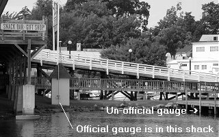
|
|
|
|
|
05-29-2006, 07:13 AM
|
#16 |
|
Senior Member
Join Date: Mar 2003
Location: Merrymeeting Lake, New Durham
Posts: 2,217
Thanks: 299
Thanked 795 Times in 365 Posts
|
Much to my surprise, Merrymeeting is almost back to normal spring level. We've dropped close to 9" since Thursday night.
The dam is fully open, and the stream/spring inflows seem to be back to normal amounts. So I expect that the output from Merrymeeting will return to normal within a day or 2 which will mean the inflow to Winnipesaukee will be similarly reduced. |
|
|
|
|
| Bookmarks |
|
|


 Linear Mode

