

|
|
|
|
|
|||||||
| Home | Forums | Gallery | Webcams | Blogs | YouTube Channel | Classifieds | Calendar | Register | FAQ | Donate | Members List | Today's Posts | Search |
 |
|
|
Thread Tools | Display Modes |
 03-06-2007, 02:02 PM
|
#1 |
|
Senior Member

Join Date: Nov 2003
Location: Central NH
Posts: 5,252
Blog Entries: 1
Thanks: 1,447
Thanked 1,349 Times in 475 Posts
|
Here is one of my absolute favorite maps of our great lake, which I’ve been working on for several years now. An 1881 B & M Map of Lake Winnipiseogee and Vicinity. Unfortunately it still isn’t perfect, but I feel it is time to share it with my forum friends. It was a black and white photocopy, which I sewed back together and cleaned up. (If you ever use a copier, do yourself a favor and copy everything in the same direction. It will make piecing it back together much easier!) I also purchased a copy of the original, but someone taped the seams on the front and sadly they show and there is also the problem of where the heck to hang it! Note many different names on islands, bays and lakes.
Opechee Bay is Round Bay Winnisquam Lake is Great Bay Paugus Bay is Long Bay with Big Island as Goat Island Meredith Bay is Northwest Bay Stonedam Island is spelled Stone Damn Fish Cove looks to me to be called Plummer’s Cove Governor’s Island is Davis Island Lock’s Island is Thompson’s Island Sleeper’s Island is Little Rattlesnake Treasure Island is Red Head Island Moose Island seems to be Varney’s Island Lake Wentworth is Smith’s Pond In addition to these, what do you see that is different? Including the surrounding lakes, ponds and mountains. (McDude, do you see Hall’s Pond?  ) )If there is a spot on the map that is not clear enough, let me know and I will try to read it on my copies or perhaps post the small piece for you. Enjoy. Hope you like it as much as I do! RG Click here for super-sized map in PhotoPost. 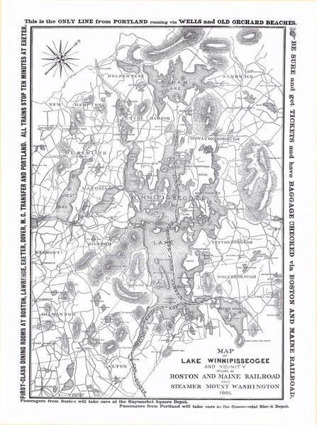
|

|

|
|
03-06-2007, 03:00 PM
|
#2 |
|
Senior Member

Join Date: Apr 2004
Posts: 5,075
Thanks: 215
Thanked 903 Times in 509 Posts
|
Great stuff RG!The only thing I might suggest is that we are only seeing part of Winnisquam and maybe the name is the same but that part of the map shows what they called Great Bay at Winnisquam?Maybe.Thanks.
__________________
SIKSUKR |
|
|
|
|
03-06-2007, 03:29 PM
|
#3 |
|
Deceased Member

Join Date: Jul 2002
Posts: 1,701
Thanks: 115
Thanked 25 Times in 13 Posts
|
Sunset Lake is Place's Pond. Here is a link to McDude's Alton Mountian history. http://www.sunsetlakehillspond.com/
|
|
|
|
|
03-06-2007, 05:07 PM
|
#4 | |
|
Senior Member

Join Date: Sep 2003
Posts: 1,943
Thanks: 23
Thanked 111 Times in 51 Posts
|
Quote:
I note that Echo Pt now was Gerrish Pt back then. I'd find it fascinating to know when and why the various names changed. I note the Little Rattlesnake was listed as such on the 1911 chart but I thought I saw Red Hen, not Red Head, on that one ?!? Must be my memory is faulty though IslandAl can verify. I see the 1886 chart sheds no new light on the Sanders/Saunders Bay question. And I note that Guernsey Island had already been renamed Cow Island at that time.
__________________
Mee'n'Mac "Never attribute to malice that which can be explained by simple stupidity or ignorance. The latter are a lot more common than the former." - RAH |
|
|
|
|
|
03-06-2007, 05:09 PM
|
#5 |
|
Senior Member
Join Date: Sep 2006
Location: 19 Mile Bay
Posts: 147
Thanks: 0
Thanked 90 Times in 29 Posts
|
Hey RG -
Great job! Some more places I found - Camp Island = Follet's Island Round Island = Smith's Island (lots of Smiths around then also!) Mirror Lake = Dishwater Pond (love that one, especially since I live nearby!) Crescent Lake = Crooked Pond Little Barndoor Island = Baker's Island Echo Point = Gerrish Point Big (or Little) Island = Goat Island It would be interesting to find out about some of the many unnamed islands on that map. Many of these old names were from the early land grants. |
|
|
|
| Sponsored Links |
|
|
|
03-06-2007, 06:25 PM
|
#6 |
|
Senior Member
Join Date: Jan 2007
Location: Meredith Center / Winnisquam
Posts: 250
Thanks: 87
Thanked 34 Times in 21 Posts
|
Great map! Thank you for sharing it. Just curious, would there have been boat access between Winnipesaukee and Winnisquam in 1881? I had never seen Winnisquam refered to as Great Bay before.
|
|
|
|
|
03-06-2007, 07:42 PM
|
#7 |
|
Senior Member
Join Date: Apr 2004
Location: Suncook, NH, but at The Lake at Heart
Posts: 2,612
Thanks: 1,082
Thanked 433 Times in 209 Posts
|
Great Job RG. I remember way back when you were just starting on this project. Your's is a labor of love for sure. Thank you for sharing with everyone.
__________________
Just Sold  At the lake the stress of daily life just melts away. Pro Re Nata |
|
|
|
|
03-06-2007, 07:45 PM
|
#8 |
|
Senior Member

Join Date: Jul 2002
Location: Rock Haven Lake - West Newfield, ME
Posts: 5,361
Thanks: 374
Thanked 1,044 Times in 490 Posts
|
I love old maps....great job stitiching this one together, RG...thanks! The first thing I notice is that this map was published at a time (1881) when only that section of the Lakeshore RR was built from Dover, NH to Alton and stopped there. The "train tracks" then proceed across the lake and indeed, the B&M Railroad owned the Mt. Washington at the time. You boarded the Mt. Washington at Alton Bay from the train and from there you could disembark at Wolfeboro, Long Island or Center Harbor. Center Harbor was the jumping off point for journeys into the White Mountains. Remember, back then there were no roads, so to speak, no cars and the the railroad was fairly new. Note that a railroad hadn't even been built to Weirs Beach yet. At Wolfeboro you could board the Wolfeboro RR and eventually connect to Portland, ME by way of Wells and Old Orchard Beach.
Most Winnipesaukee maps don't show Hill's Pond or Sunset Lake (*Hall's Pond as it was referred to by Roger Amsden in his article about Forum Fest I in the Weir's Times  ) ...so I especially like this map. ) ...so I especially like this map. here ....more specifically, is the link Sunset Bob is referring to ALTON MOUNTAIN HISTORY Belknap Lakes is now hosted on the same server as winni.com and snake eyes. When I switched, I signed up for some "masking" feature (which I need to undo) which is why Sunset Bob couldn't capture the link. Love the map, RG!!! 
__________________
|
|
|
|
|
03-06-2007, 08:22 PM
|
#9 |
|
Senior Member
Join Date: Jul 2002
Location: Rock Haven Lake - West Newfield, ME
Posts: 5,361
Thanks: 374
Thanked 1,044 Times in 490 Posts
|
RG: Note that although there may be no Hall's Pond...just south of Lougee Pond there is a Hall's Hill!!
Here's a photo of "Lougee Pond" (Now Crystal Lake in Gilmanton Iron Works) from Hall's Hill...  Other changes of note from the "Belknap Lakes" area of the map Lougee Pond - now Crystal Lake (as Sunset Bob noted....) Place's Pond now Sunset Lake (It was called Place's Pond after a man by the name of "Place" who dammed (damned?) the Suncook Brook for a mill that created Place's Pond Young's Pond now Manning Lake Round Pond now Lake Eileen (part of the Boy Scout Reservation) Factory Reservoir now Sawyer Lake
__________________
|
|
|
|
|
03-06-2007, 10:25 PM
|
#10 |
|
Senior Member

Join Date: Feb 2004
Location: Mountonboro
Posts: 200
Thanks: 12
Thanked 0 Times in 0 Posts
|
On the 1911 map I have, I see Redhead I. (as one word) beside Little Rattlesnake; Sanders Bay (still spelled this way), Mirror Lake was also listed as Lang's Pond (so that gives it a third name), still Gerrish Point and not Echo Pt yet; both Lake Wentworth and Smith's Pond listed on the same water; Stonedam Island spelling updated, Long Bay still listed, Governor's I. named as such;
I love the note between Timber and Governors "Witch Rocks Keep Off" ")
|
|
|
|
|
03-07-2007, 10:26 AM
|
#11 |
|
Senior Member
Join Date: Feb 2004
Location: Mountonboro
Posts: 200
Thanks: 12
Thanked 0 Times in 0 Posts
|
Does anyone know where I could get my old cloth backed 1911 repaired. Many areas separated from the backing and curled.
|
|
|
|
|
03-07-2007, 03:22 PM
|
#12 | |
|
Senior Member
Join Date: Apr 2004
Posts: 5,075
Thanks: 215
Thanked 903 Times in 509 Posts
|
Quote:
__________________
SIKSUKR Last edited by SIKSUKR; 03-08-2007 at 08:33 AM. |
|
|
|
|
|
03-07-2007, 06:28 PM
|
#13 |
|
Senior Member
Join Date: Jul 2002
Location: Rock Haven Lake - West Newfield, ME
Posts: 5,361
Thanks: 374
Thanked 1,044 Times in 490 Posts
|
Now I see it! I guess it isn't as pronounced since it is a Boston and Maine RR map. I see that the steamer serving the Weirs was Our Lady of the Lake and not the Mt. Washington..... that's different!
__________________
|
|
|
|
|
03-07-2007, 11:19 PM
|
#14 |
|
Senior Member
Join Date: Apr 2004
Location: NH
Posts: 2,689
Thanks: 33
Thanked 439 Times in 249 Posts
|
On the bottom it says: Passegers from Boston will take cars from Haymarket Square Depot. So is that a different name for North Station or a different Bean town train station.
|
|
|
|
|
03-08-2007, 06:06 AM
|
#15 | |
|
Senior Member
Join Date: Apr 2004
Location: Suncook, NH, but at The Lake at Heart
Posts: 2,612
Thanks: 1,082
Thanked 433 Times in 209 Posts
|
 Quote:
Trains at one time probably started there as this was a hub for people to go to.
__________________
Just Sold At the lake the stress of daily life just melts away. Pro Re Nata |
|
|
|
|
|
03-08-2007, 04:19 PM
|
#16 |
|
Senior Member
Join Date: Apr 2004
Location: Fairfield, CT & island vacation
Posts: 97
Thanks: 8
Thanked 0 Times in 0 Posts
|
It looks like Camp Isl. and Little Camp are one island and Steamboat and Birch are one island. Both of those areas only have a few feet of water to separate the land masses. Is it possible the lake was more than 4 ft lower?
|
|
|
|
|
03-08-2007, 05:59 PM
|
#17 | ||
|
Senior Member
Join Date: Jul 2002
Location: Rock Haven Lake - West Newfield, ME
Posts: 5,361
Thanks: 374
Thanked 1,044 Times in 490 Posts
|
Quote:
Quote:

__________________
|
||
|
|
|
|
03-08-2007, 11:03 PM
|
#18 |
|
Senior Member
Join Date: Jan 2005
Posts: 2,084
Thanks: 1,267
Thanked 557 Times in 286 Posts
|
What would you give to go back in time and spend a summer in NE in 1900 or there abouts? Strating off with a train ride from Boston to Winnipesaukee on Memorial Day so you could work as a bar back at one of the grand hotels in the region during your summer vacation...........Priceless.
|

|
|
|
03-09-2007, 12:28 PM
|
#19 | |
|
Senior Member
Join Date: Sep 2003
Posts: 1,943
Thanks: 23
Thanked 111 Times in 51 Posts
|
Quote:
__________________
Mee'n'Mac "Never attribute to malice that which can be explained by simple stupidity or ignorance. The latter are a lot more common than the former." - RAH |
|
|
|
|
|
03-09-2007, 01:25 PM
|
#20 | |
|
Senior Member

Join Date: Feb 2006
Location: Weirs Beach, NH
Posts: 1,067
Thanks: 0
Thanked 1 Time in 1 Post
|
Quote:
__________________
Is it bikeweek yet? Now? |
|
|
|
|
|
03-10-2007, 03:19 PM
|
#21 | |
|
Senior Member
Join Date: Nov 2003
Location: Central NH
Posts: 5,252
Blog Entries: 1
Thanks: 1,447
Thanked 1,349 Times in 475 Posts
|
Can I guess a cartographer from this era might have used the local mountains to gain an aerial view of the lake?
Quote:
You would enjoy reading Farewell Old Mount Washington by Edward H. Blackstone and Three Centuries on Winnipesaukee by Paul Blaisdell. |
|
|
|
|
|
03-11-2007, 09:32 AM
|
#22 |
|
Senior Member
Join Date: Apr 2004
Location: Exeter, NH or @ WCYC on weekends
Posts: 250
Thanks: 7
Thanked 46 Times in 28 Posts
|
I made this statement before and Ill make it again: The old shore line at the 18 foot depth is very evident all along the lake. Its like following along an old stone wall. This depth just so happens to coincide with the height of the dam in Lakeport built in 1822. There is an old Indian encampment in Dug Hill cove that lends credence to my theory. Our dive group spent days a few years back, sifting through the bottom in the 10 to 12 depth range and came up with all sorts of artifacts; I still have some of the items I found. With the fire rings still there it had to have been above the water level.
Another interesting item that I found is off east end of Hopewell point: there are several ridges that run in the southeast direction and it shoals up mid way between the point and Little Barn Door Island. Just beyond this area in 30 range, lying on the bottom is a 3 foot diameter iron ball tethered to a granite block by a 20 chain. Since the ball has yellow and black paint on it we presume it was a mid channel marker, yet the scope of the chain is to shot to reach the surface unless it was there before the dam. Yes, we have had this discussion before and you guys make a good point about the Weirs channel and its depth. However, I remember seeing a picture of channel before the bridge and it was a lot wider. Since the bridge is a stone arch, perhaps they had to fill the area to keep its height within reason. My theory was blown out of the water the last time by the writing of some old lady and her cut on the history of the lake, however, some of her facts dont add up by what I see below the surface. But, since it had been written, it must be true. Isnt there an old saying about believing what you see, some of what you read and none of what you hear or something to that effect? |
|
|
|
|
06-27-2008, 08:50 AM
|
#23 | |
|
Member
Join Date: Dec 2004
Posts: 26
Thanks: 0
Thanked 0 Times in 0 Posts
|
Quote:
On this map I see that it appears that Belknap and Gunstock are reversed. Error I assume? I also see that as far back as 1881 the peaks were called Major and Straightback. Anyone have info on how they got their names. |
|
|
|
|
|
06-27-2008, 02:24 PM
|
#24 |
|
Senior Member
Join Date: Jul 2002
Location: Rock Haven Lake - West Newfield, ME
Posts: 5,361
Thanks: 374
Thanked 1,044 Times in 490 Posts
|
carole:
As I type, I am looking at Straightback Mountain. I don't know this for sure but I would have to guess that it is called "Straightback" is because it does not form a peak at the top, but rather a straight back....like a spine. Don't you think so? 
|
|
|
|
|
06-28-2008, 07:00 AM
|
#25 | |
|
Member
Join Date: Dec 2004
Posts: 26
Thanks: 0
Thanked 0 Times in 0 Posts
|
Quote:
Interestingly, the nice map from 1771 only mentions the area where the Belknap Range would be as The Kings Woods http://www.winnipesaukee.com/forums/...ead.php?t=6116 On the map from 1784 it names Mt. Major only (somehow I have the map link but cant find the thread it was from.) http://www.winnipesaukee.com/photopo...iokee_Lake.jpg |
|
|
|
|
|
06-28-2008, 08:08 AM
|
#26 |
|
Deceased Member
Join Date: Feb 2004
Posts: 1,317
Thanks: 0
Thanked 1 Time in 1 Post
|
Carole,
The swapping of names between Belknap and Gunstock Mts did in fact happen - there are old histories of Gilford in the Gilford Library that do attest to the fact that at one time or another each of those mountains was named both Gunstock or Belknap. Before Belknap was officially named to honor Jeremy Belknap, whose 18th century book on the history of NH won him considerable acclaim nationally for writing one of the very first serious histories of a colony, the present Mt Belknap was named Gunstock.When the first white men came to the Gilford area (which was part of Gilmanton at the time) they had a special event happen to them on the large mountain, in which the stock of a musket of one of the men was broken, (there are at least 2 versions of just how it got broken - one involving a poorly felled tree and the other the killing of an attacking mountain lion by hitting it over the head with the gun) and they named the mountain Gunstock because of their felt significance of that event. Names of mountains can be very volatile - the most recent example of changed names of significant features of the Belknap Range has happened within the last few decades, when the scouts renamed several features of their newly acquired property (including Lake Eileen - formerly known as Woodmans Pond, Sanctity Pond, Lower Round Pond, and who knows what else, and Mt Klem, which I've been told was formerly known as Goves Mt. |
|
|
|
|
06-28-2008, 06:08 PM
|
#27 |
|
Member
Join Date: Dec 2004
Posts: 26
Thanks: 0
Thanked 0 Times in 0 Posts
|
Thank you, dcr.
I did a bit of online searching and found some interesting info that may be already known to some here but is new to me. Interesting scanning of Gilford history & genealogy (http://www.nh.searchroots.com/belknap.html) mentions several names that may / may not relate to the names of the summits in the Belknap Range (Major [and Minor, aka Piper], Gunstock [Gunstock Hill?], Rowe, Rand (it also states Gilmanton Mountain is the highest? ..referring to Belknap Mountain?) and a Gove family: a Benjamin Weeks settling western base of Mt. Major Esquire Benjamin Weeks, who came in the lower part of the town in 1768, led a party into the upper section and located at the western base of Mount Major, in 1787, where there afterwards dwelt a large community of that name. He was a large landholder, and successful in business. COLONEL PEASLEE HOYT settled at the base of Mount Major; NATHANIEL on Liberty Hill; SIMEON Jr., ENOCH JR. and THOMAS near Chattleborough Pond. SAMUEL FOSS was early living near Mount Minor. Also further down a Plummer family HENRY PLUMMER came early to Gilmanton. HENRY JR. settled at the base of Mount Minor, or the Piper Mountain; he was a mason by trade. WILLIAM or BILLY PLUMMER is in the list, and JESSE PLUMMER also lived near the mountain. The PIPER family was settled first in the southeastern part of the town LEVI, JOHN and JETHRO GOSS settled on the north part of Gunstock Hill, ELIJAH GOVE settled on the west side of Gunstock Hill LIEUTENANT PHILBROOK RAND settled near ABEL HUNT's in 1790, and north of Gunstock Hill, and improved some excellent land. The family still occupy the old homestead, and Simon, his son, has been a prominent citizen. JOSEPH RAND lived awhile at the village, and removed from the town in its first years. The RAND family was not large. GEORGE RAND was once a resident, but emigrated early, and SAMUEL also. The ROWE family is quite extensive and was early settled in the place. EZEKIEL and JACOB came in 1796. JEREMIAH appears soon after, and RICHARD and SAMUEL; also JEREMIAH (2d and 3d), and JOSEPH. They settled in the south aprt of the town, near Liberty and Cotton's Hills. KELLEY ROWE was afterwards a Baptist preacher, though never ordained. BENJAMIN ROWE came from Brentwood in 1816, and worked at the wool-carding business, at the Upper Mill, near Hoyt's saw-mill, and also at the Lower Mill, whither the machinery was improved. He also carried on farming, brick-making and the making of farming implements, as wheels, plows, rakes, etc. He lived to be nearly one hundred years old Gilfords Benjamin Rowe farm house http://www.gilfordhistoricalsociety..../rowehouse.htm WILLIAM SIBLEY early settled near Gunstock Mountain. His father was the first merchant at Gilmanton. The name of SLEEPER is represented by ESQUIRE NEHEMIAH, HENRY, JOSEPH and JONAS. NEHEMIAH ESQ. settled on the lake-shore, near Esquire Evans', and was possessed of a good estate, to which GEORGE, now of Laconia, succeeeded. JOSEPH and HENRY were settled near Wm. Sibley's at the west base of Gunstock Mountain, On the Gilmanton history & genealogy page: A Mackis mentioned, but if that has any connection to Mt. Mack I do not know. Regarding Durrell Mt. and Durrell Mountain road: Mr. Durrell remained in Gilmanton, making additions to his farm until he woned about two thousand five hundred acres, in one body, and gave his name to Durrell's Mountain. An old citizen informs us that Mr. Durrell told him that he had made about forty miles of stone wall, and to the observer of the work today, it would seem as if this was rather under than over-estimated.... |
|
|
|
|
| Bookmarks |
|
|


 Linear Mode

