

|
|
|
|
|
|||||||
| Home | Forums | Gallery | Webcams | Blogs | YouTube Channel | Classifieds | Calendar | Register | FAQ | Donate | Members List | Search | Today's Posts | Mark Forums Read |
 |
|
|
Thread Tools | Display Modes |
 08-06-2009, 09:45 PM
|
#1 |
|
Senior Member
Join Date: May 2009
Posts: 187
Thanks: 2
Thanked 51 Times in 32 Posts
|
I am trying to research the history of the alignment of NH 28 from Alton to Wolfeboro and on to Ossipee.
I remember as a child the long drive from NYC to Wolfeboro, before the interstates. It seems to me that the road from Alton took a much more indirect route than it does now. And tonight, I saw a 1959 Lake Winnipesaukee Navigation Chart which had Beech Pond Road in Wolfeboro labelled as Rte 28 "to Ossipee". Any information would be greatly appreciated. |

|

|
|
08-06-2009, 10:42 PM
|
#2 |
|
Senior Member

Join Date: Apr 2004
Posts: 5,075
Thanks: 215
Thanked 903 Times in 509 Posts
|
Rt 28 has been in its current path in all my 51 years that Im aware of.The interstates have gone through quite a change even in my time.I remember when I-93 stopped in Plymouth.
__________________
SIKSUKR |
|
|
|
|
08-07-2009, 03:17 PM
|
#3 |
|
Senior Member

Join Date: Apr 2004
Location: formerly Winter Harbor, still Wolfeboro
Posts: 1,133
Thanks: 284
Thanked 480 Times in 271 Posts
|
Ok, gokart, I'll take a stab at some of it. I hope someone with an actual map from the 1940s will chime in and help out. The road from the south end of Alton used to run into Alton Bay (pretty much as it does now) and then follow the Lake along what is now listed as 28A, until it connected (somehow) to the south end of Roberts Cove Road following RCR northward until connecting back to the "main" road. This lead into Wolfeboro pretty much along the same road as is in play today. The current Rt 28 took out some really serious turns along the Lake, and, or course, is wider and safer.
I hope this helps, or, at least, prompts someone to offer a better answer. |
|
|
|
|
08-07-2009, 05:16 PM
|
#4 |
|
Senior Member

Join Date: Jul 2002
Location: Rock Haven Lake - West Newfield, ME
Posts: 5,359
Thanks: 374
Thanked 1,041 Times in 489 Posts
|
Old postcards indicate that Robert's Cove was on the Old Wolfeboro Road. I'm sure there's a map on photopost....but photopost is down right now!
__________________
|
|
|
|
|
08-07-2009, 06:10 PM
|
#5 |
|
Senior Member

Join Date: Jan 2006
Posts: 6,400
Thanks: 718
Thanked 1,378 Times in 954 Posts
|
That is correct, mcdude. Robert's Cove Road was the old Alton road.
Beech Pond Road was never Rte. 28 (going to Ossipee) unless it was long before any of our lifetimes. Most of those bits and pieces of roads on 28 both on the Ossipee to Wolfeboro section and Wolfeboro to Alton section were the old Rte. 28. The new Alton section of Rte. 28 was built around 1966 The Ossipee section was built (I think way) before that but I can't tell you when. |

|
|
| Sponsored Links |
|
|
|
08-07-2009, 09:30 PM
|
#6 |
|
Senior Member
Join Date: May 2009
Posts: 187
Thanks: 2
Thanked 51 Times in 32 Posts
|
Thanks, tis, the 1959 Lake Winni Navigation Chart didn't really make sense to me - it shows 28 and 109 as separate, with 28 following 109A out to Beech Pond Road and then North to (I assume) 171. Perhaps the Nav Chart maker just didn't know the roads that well.
The Alton-Wolfeboro info posted here makes sense. 28 was Main Street in Alton, then 28A to (at least) Chestnut Cove Road, then to the current 28-Roberts Cove Road intersection (we don't know the routing of the Wolfeboro Road between the Western intersection of Chestnut Cove Road-28A and RCR). I remember when we passed the then Eye-Joy Cottages on RCR that it was a sign we were finally getting close. Was Drew Hill Road part of this picture? I mean, 28A to current 28, then somehow connecting to the East Alton Meetinghouse Rd, then Drew Hill to RCR? Thanks to all for the info. Keep it coming. |
|
|
|
|
08-09-2009, 12:53 PM
|
#7 |
|
Senior Member
Join Date: Jul 2002
Location: Rock Haven Lake - West Newfield, ME
Posts: 5,359
Thanks: 374
Thanked 1,041 Times in 489 Posts
|
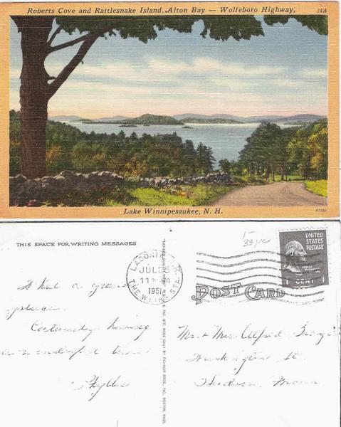
Here's that postcard I was referring to. Upthesaukee correctly notes that there is an extra island in the postcard in front (and to the right) of Rattlesnake.
__________________
|
|
|
|
|
08-09-2009, 01:05 PM
|
#8 |
|
Senior Member
Join Date: Jul 2002
Location: Rock Haven Lake - West Newfield, ME
Posts: 5,359
Thanks: 374
Thanked 1,041 Times in 489 Posts
|
I'm not sure of the date on this but I'm guessing 1892. Note that Wolfeboro Road takes quite an inland route. The part in Alton is still known as Old Wolfeboro Road. What is now known as 28A or Eastside Drive (as it is called on old postcards) was NOT the Wolfeboro Road.
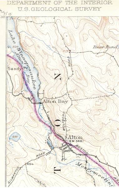 CLICK HERE to SUPER-SIZE the MAP
__________________
|
|
|
|
|
08-09-2009, 01:10 PM
|
#9 |
|
Senior Member
Join Date: Jul 2002
Location: Rock Haven Lake - West Newfield, ME
Posts: 5,359
Thanks: 374
Thanked 1,041 Times in 489 Posts
|
Here's a 1962 Fishing Map which places Rt. 28 right down by the lake and directly past Robert's Cove.
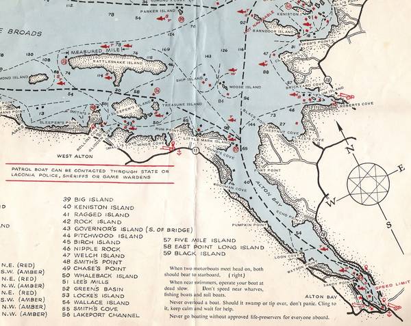 CLICK HERE to SUPER-SIZE
__________________
|
|
|
|
|
08-09-2009, 02:56 PM
|
#10 |
|
Senior Member
Join Date: Apr 2004
Location: Suncook, NH, but at The Lake at Heart
Posts: 2,612
Thanks: 1,082
Thanked 433 Times in 209 Posts
|
McD's map from 1962 show what I remember.
Over the last few years I have even re-traced the path of the 1962 Rt 28. I have been able to see various buildings along that route today that were there in the late 50's and early 60's when we drove to Wolfeboro. When the State did the "straightening of RT. 28" The McLeod Family (of Melrose, MA) whose lake front summer home is just over the line from Alton in Wolfeboro had a significant amount of their back land taken by eminent domain for the new Rt 28. Sure shorted their dirt road drive in off of 28.
__________________
Just Sold  At the lake the stress of daily life just melts away. Pro Re Nata |
|
|
|
|
08-09-2009, 03:11 PM
|
#11 |
|
Senior Member
Join Date: Apr 2004
Location: formerly Winter Harbor, still Wolfeboro
Posts: 1,133
Thanks: 284
Thanked 480 Times in 271 Posts
|
Speaking of old routes, does anyone remember going south on Rt 125 through Plaistow and Haverhill (MA) to get to the Boston area ? My fondest memory of that route is stopping at Was-Maco Ice Cream Creamery in Plaistow, right on the Plaistow/Haverhill line. Their 'small' was everyone else's 'jumbo', and it went up from there. Just a pleasant memory.
|
|
|
|
|
08-09-2009, 04:53 PM
|
#12 |
|
Senior Member
Join Date: Jul 2002
Location: Rock Haven Lake - West Newfield, ME
Posts: 5,359
Thanks: 374
Thanked 1,041 Times in 489 Posts
|
Did you know that Rt. 28 actually begins at the traffic circle in Orleans, MA? It proceeds through Hyannis, Falmouth, over the canal and then up through Wareham, Middleboro, Bridgewater, Brockton, Randolph, Milton, Mattapan, Roxbury......over the Charles River via the Salt and Pepper Bridge and past the Museum of Science before proceeding up through Mass to NH? I live right off of Rt. 28 (Main St.) down here south of Boston. I wonder how long it would take me to get to Alton Bay if I followed Rt. 28 all the way?
__________________
|
|
|
|
|
08-10-2009, 08:44 AM
|
#13 |
|
Senior Member
Join Date: May 2009
Posts: 187
Thanks: 2
Thanked 51 Times in 32 Posts
|
Lots of helpful information yesterday!
The named "Wolfeboro Road" (which is still there, named "Old Wolfeboro Road") took an inland route (and also a much higher elevation), and joined the route designated as NH 28 somewhere in East Alton. The original NH 28 followed Main Street to Alton Bay, and then followed present-day 28A to at least the present 28A-Chestnut Cove Road intersection. From the present 28A-Chestnut Cove Road intersection to the current 28-Roberts Cove Road intersection, the layout of original NH 28 remains unknown. Original NH 28 then followed Roberts Cove Road over its entire present course, except that I suspect it followed the current left-bearing blind spur rather than the present right-bearing main road to rejoin the Wolfeboro Road in more or less its present alignment to Weston Auto Body. The two questions left are: 1) What was the path of original NH 28 from the current 28A-Chestnut Cove intersection to the current southerly NH 28-Roberts Cove Road intersection? 2) Where did the inland "Wolfeboro Road" join original NH 28? I suspect that the original NH 28 included present Quarry Road and Gilman's Corner Road, as well - but between Gilman's Corner Road+current NH 28 and current 28A+Chestnut Cove Road, I'm lost. |
|
|
|
|
08-10-2009, 05:42 PM
|
#14 | |
|
Senior Member

Join Date: Dec 2006
Posts: 534
Thanks: 19
Thanked 134 Times in 61 Posts
|
Quote:
|
|
|
|
|
|
08-11-2009, 12:44 PM
|
#15 | |
|
Senior Member

Join Date: Apr 2009
Location: Somewhere betwixt Gonic and Chocorua
Posts: 191
Thanks: 13
Thanked 30 Times in 21 Posts
|
Quote:
(The ponds you see in that area are what's left from the claypits that they dug when the Westville section of Plaistow - the part centred on basically where Dunkin Doughnuts and the old Westville Market were - was a brickmaking center). I remember seeing movies at the old drive-in and grabbing a grinder at the old Danos A-frame acrosst the street. I learned how to swear by listening to my grandmother give hell to the owner of Skip's gas (by Larry's Clambar). He used to insist on pumping the gas. She suspected him of shorting her. Her special nickname for ole Skip was Skimp. Thanks for the memory!
__________________
Plant a garden. Heat with wood. And thank a veteran. |
|
|
|
|
|
08-18-2009, 07:54 AM
|
#16 | |
|
Senior Member
Join Date: Apr 2004
Posts: 5,075
Thanks: 215
Thanked 903 Times in 509 Posts
|
Quote:
 I would guess a no-wake zone. I would guess a no-wake zone.
__________________
SIKSUKR |
|
|
|
|
|
08-18-2009, 10:37 AM
|
#17 | ||
|
Senior Member

Join Date: Apr 2004
Location: Bow
Posts: 1,874
Thanks: 521
Thanked 308 Times in 162 Posts
|
Quote:
Quote:
Many moons ago, I dated a girl who lived in Milton while I lived in Lynnfield. One Saturday night, I thought it would be kinda fun to drive home from Milton via Rt 28. Not sure how long I stayed on it, but it wasn't very long. As soon as I was getting into Mattapan, I started looking for signs to I-93. I bailed at the first one I saw.
__________________
Getting ready for winter! |
||
|
|
|
|
08-18-2009, 03:29 PM
|
#18 |
|
Senior Member
Join Date: Apr 2007
Posts: 93
Thanks: 12
Thanked 33 Times in 12 Posts
|
In response to gokart-mozart's questions above, I have an 1892 map of Alton in my home that shows some of the older road configurations. It also shows the names of the homeowners. It is a different map than the one mcdude showed above. You can see it and zoom in/out at the following link.
http://www.wardmaps.com/viewasset.php?aid=4977 It seems to show that there was no 28A then. There was the Old Wolfeboro Rd you mentioned that intersects the current 28 across from the current 28A. As you mention, current evidence of the connection between this point and Gilmans Corner Rd is not visible on modern maps, but I suspect the route may have been on the west side of the current 28 near the Catholic Church. Then the route would have continued on Gilmans Corner Rd and turned left onto the current Quarry Rd which becomes Roberts Cove Rd. Then I think that it followed the current Roberts Cove Rd across the current 28 and onto Rines Rd where it turned left onto what is marked in Mapquest as Stagecoach Road. This continued northeasterly until it intersected with the current Rt 28 near Gould Rd right before the Wolfeboro line. The last portion of this connection is no longer a road but if you are on the current 28, you can see the old road grade on the east side of the highway. That is my best guess for how the old route made its way through Alton based on the 1892 map. The last part of the route I mentioned from Roberts Cove Rd to Rines Rd to Stagecoach Rd was based in part on the recollection of a neighbor who has been coming to the lake for many years. |
|
|
|
|
08-18-2009, 10:54 PM
|
#19 | |
|
Senior Member
Join Date: May 2009
Posts: 187
Thanks: 2
Thanked 51 Times in 32 Posts
|
Quote:
If anybody can identify the Old Wolfeboro Road-Hidden Springs Road intersection, please speak up. |
|
|
|
|
|
08-19-2009, 11:35 AM
|
#20 |
|
Senior Member

Join Date: Apr 2004
Location: Wolfeboro
Posts: 521
Thanks: 10
Thanked 29 Times in 15 Posts
|
Lone Pine,
Your map looks like the old postal maps of Wolfeboro etc. If you check around where the post office is there are no houses since they are not RFD locations.
__________________
Home Permanently in NH
 |
|
|
|
|
08-19-2009, 11:52 AM
|
#21 | |
|
Senior Member
Join Date: Apr 2009
Location: Somewhere betwixt Gonic and Chocorua
Posts: 191
Thanks: 13
Thanked 30 Times in 21 Posts
|
Quote:
UNH has digitized the Hurd atlas, which is searchable at the following site: http://docs.unh.edu/Hurd/pages/Belknap.htm The link is to the Belknap index. But you can use the dropdown menu to select towns indexed by all 10 NH counties. 
__________________
Plant a garden. Heat with wood. And thank a veteran. |
|
|
|
|
|
08-20-2009, 10:22 AM
|
#22 | |
|
Senior Member
Join Date: Apr 2007
Posts: 93
Thanks: 12
Thanked 33 Times in 12 Posts
|
Quote:
|
|
|
|
|
|
08-20-2009, 02:27 PM
|
#23 | |
|
Senior Member
Join Date: May 2009
Posts: 187
Thanks: 2
Thanked 51 Times in 32 Posts
|
Quote:
You are obviously correct! Thanks! Now, all that's needed is an old plan from the East Alton Store to the present Gilman's Corner Road/NH 28 intersection (which must pass through the parking lot of St. Katherine Drexel Church), and the whole route is done. |
|
|
|
|
|
08-20-2009, 02:30 PM
|
#24 | |
|
Senior Member
Join Date: Apr 2009
Location: Somewhere betwixt Gonic and Chocorua
Posts: 191
Thanks: 13
Thanked 30 Times in 21 Posts
|
Quote:
__________________
Plant a garden. Heat with wood. And thank a veteran. |
|
|
|
|
|
08-20-2009, 03:56 PM
|
#25 |
|
Senior Member
Join Date: Apr 2007
Posts: 93
Thanks: 12
Thanked 33 Times in 12 Posts
|
If you go to www.nhdeeds.com for Belknap county and go to Plan Drawer "L47" and Plan Number "9", you will see a survey of the land that was sold to the Catholic church. On it is reference to "Hidden Springs Road a/k/a Old Route 28" (confirming the earlier suspicion about the routing of Old 28). An older plan found at Plan Book 76 page 73 shows what the property looked like in 1974.
|
|
|
|
|
08-24-2009, 10:50 PM
|
#26 |
|
Senior Member

Join Date: Jul 2002
Location: North Kingstown RI
Posts: 688
Thanks: 143
Thanked 83 Times in 55 Posts
|
I remember when the "new" Rt 28 was built it made it a lot faster getting to my aunt's house in South Wolfeboro but I missed seeing Alton Bay and the wooden speedboats there and all those houses with "garages" facing (and in) the water. I am guessing it was in the late 50s as it was a few years before I got my driver's license.
__________________
Gene ~ aka "another RI Swamp Yankee" |
|
|
|
|
08-25-2009, 06:27 AM
|
#27 |
|
Senior Member
Join Date: Jan 2006
Posts: 6,400
Thanks: 718
Thanked 1,378 Times in 954 Posts
|
I am pretty sure the new Rte. 28 was completed in 1966.
|
|
|
|
|
08-25-2009, 08:26 AM
|
#28 | |
|
Senior Member

Join Date: Feb 2003
Location: Cow Island
Posts: 914
Thanks: 602
Thanked 193 Times in 91 Posts
|
Quote:
|
|
|
|
|
|
08-28-2009, 08:39 AM
|
#29 |
|
Senior Member

Join Date: Mar 2004
Location: Piscataway, NJ
Posts: 1,030
Thanks: 2
Thanked 46 Times in 24 Posts
|
Sitting in the back seat of dad's '53 or my grandfathers '59 Chevys the ride to Wolfeboro was twistier then now. Rt 28 used to be a winding road.
So was Rt 11 going to Laconia. |
|
|
|
|
| Bookmarks |
| Thread Tools | |
| Display Modes | |
|
|


 Linear Mode

