

|
|
|
|
|
|||||||
| Home | Forums | Gallery | Webcams | Blogs | YouTube Channel | Classifieds | Calendar | Register | FAQ | Donate | Members List | Today's Posts | Search |
 |
|
|
Thread Tools | Display Modes |
 05-26-2004, 01:52 PM
|
#1 |
|
Member

Join Date: Jan 2003
Location: Gilford-Northern MA
Posts: 38
Thanks: 3
Thanked 5 Times in 2 Posts
|
I am looking to get out and do some hiking this weekend. Any suggestions for good trails around the lake....that welcome dogs??? I have done the Mt. Major hike numerous times and would like to try something different.
 Any suggestions would be greatly appreciated Any suggestions would be greatly appreciated 
__________________
Lakegirl Never leave home without your camera 
|

|

|
|
05-26-2004, 04:37 PM
|
#2 |
|
Senior Member

Join Date: Jul 2002
Location: Rock Haven Lake - West Newfield, ME
Posts: 5,361
Thanks: 374
Thanked 1,044 Times in 490 Posts
|
Hi LG:
Between the black flies and the tics be sure to wear some bug spray. Deep Woods Off helps tremendously. And check the dog thoroughly before letting him back in the car! I have put together some info on hiking in the Belknaps which I will post below. If you haven't been up Locke's Hill that is an easy hike with fantastic views. If you have not been up to Belknap Mt. that also is a good take. You drive up a winding road with switchback curves over rushing rivers. If that wasn't excitement enough, then you get to the trailhead! At the top there is a fire tower you can climb. By all means bring your camera and share your photos! There are marked trails at the top that connect to Rowe, Gunstock, Major and Straightback if you are really ambitious. click here for Belknap Trails This link has info about trails at Red Hill and Squam Lake link to Red Hill trail info Finally, the Lakes Region Conservation Trust maintains many "publicly-accessible" properties including Stondam Island and Five Mile Island. On my "to do" list is Copple Crown in Brookfield/Wolfeboro where I understand there is a fantastic view of the lake. Stonedam and Copple Crown Other Lakes Region Conservation Trust Properties Have fun!  and don't rely on your cell phone if you get in a jam. It may not work up in the mountains! and don't rely on your cell phone if you get in a jam. It may not work up in the mountains! McD 
Last edited by mcdude; 09-30-2004 at 09:51 AM. |
|
|
|
|
05-26-2004, 06:55 PM
|
#3 |
|
Member
Join Date: Jan 2003
Location: Gilford-Northern MA
Posts: 38
Thanks: 3
Thanked 5 Times in 2 Posts
|
McD...thanks for all the great advice and links. I will be sure to bring lots of bug spray!!! I haven't been up the Locke's trail in many many years. There have been sightings of bears in that area recently so I will have to be really cautious!!! I will be sure to bring camera and take lots of photos.
LG
__________________
Lakegirl Never leave home without your camera
|
|
|
|
|
05-27-2004, 08:00 PM
|
#4 |
|
Senior Member

Join Date: Jul 2002
Location: Pennsyltuckey, Tuftonboro, Moultonborough
Posts: 1,485
Thanks: 337
Thanked 212 Times in 116 Posts
|
Anything the sandwich range provides great views of both Winni and the Squams -- and are not heavily traveled. The Ossipees are a personal and local favorite -- with Bald Knob affording excellent views of the Lake and a unique view of Castle in the Clouds (Lucknow). In recent years, my family and I have fallen in love the with Sandwich Range as a convenient and less-traveled alternative to the White Mountains. Easily accessible from Moultonborough & Rte. 25.
A shot taken atop one of the Sandwich Mts. last August: http://www.pbase.com/image/20656610 |
|
|
|
|
05-28-2004, 05:09 PM
|
#5 |
|
Senior Member
Join Date: May 2004
Location: Giford
Posts: 66
Thanks: 0
Thanked 12 Times in 10 Posts
|
Grant's suggestion is a good local hike. Morgan & Percival are a very nice loop with great views into the Whites As well as an overview of the Squams and Rattlesnake from above. Even has some fun cave routes for the kids, with alternate short bypasses for those who don't care for a bit of a scamble.The trail head is across the road from Rattlesnake trail which is an even quicker hike. ( Cheap hike, short walk, great view ). 3 hr. loop
|
|
|
|
| Sponsored Links |
|
|
|
06-14-2004, 09:39 AM
|
#6 |
|
Senior Member

Join Date: Apr 2003
Location: Massachusetts & Moultonborough
Posts: 673
Thanks: 41
Thanked 15 Times in 11 Posts
|
We also enjoy the Sandwich Range. Different views, unspoiled and not heavily used like some of the other mountains and trails around the lake.
__________________
Lin |
|
|
|
|
09-30-2004, 08:44 AM
|
#7 |
|
Junior Member
Join Date: Apr 2004
Posts: 7
Thanks: 0
Thanked 0 Times in 0 Posts
|
Does anyone know of any hiking trails in Tuftonboro?
Thank you, Summertm |
|
|
|
|
10-01-2004, 07:06 AM
|
#8 |
|
Senior Member

Join Date: Nov 2003
Location: Central NH
Posts: 5,252
Blog Entries: 1
Thanks: 1,447
Thanked 1,349 Times in 475 Posts
|
I cannot find any trails in Tuftonboro. Here is a good link for the lakes region.
Lakes Region Hiking |
|
|
|
|
10-01-2004, 09:30 AM
|
#9 | |
|
Senior Member
Join Date: Apr 2004
Posts: 381
Thanks: 0
Thanked 1 Time in 1 Post
|
Quote:
Just to the the right of the 171 intersection is a tiny bridge over the Melvin River. You'll find there a small unpaved parking area in the woods, hidden behind the Armco rail barrier, and suitable for five cars, max. The trail begins there, is mostly tree-shaded, gently-sloped, and well marked. It follows the river northward. You may see only one other hiking party on this trail. (And they may have gotten lost from a Bald Knob hike). Less than an hour up the trail is a wide, flat, pine grove next to a noisy brook and waterfall -- ideal for a picnic. The trail continues on, but is eroded, with lots of bare rocks making for a tricky climb. There's a nice view of the lakes and mountains to the north near the summit -- though there is no view of Winnipesaukee. (You are following a river valley). Should you want to take any of the trails that branch off the main trail, it is easy walking, but it's also easy to get "lost". Start early if you're feeling adventurous. (If you do get lost, hike downhill -- you'll hit a highway eventually). Though it's probably "Bear Country", I've never seen so much as a chipmunk in that valley. The bears are out looking for pizza. |
|
|
|
|
|
10-01-2004, 11:34 AM
|
#10 |
|
Senior Member

Join Date: Apr 2004
Posts: 176
Thanks: 19
Thanked 14 Times in 11 Posts
|
Isn't that the trail up Mt Shaw? It eventually connects with one of the old carriage roads on the way to the summit. The view from the top is disappointing, but there are a couple of good views on the way up. I hiked it in the fall, and the pine grove with waterfall would have been a great spot on a 90 degree summer day. It's a rocky trail and apt to be wet if it has rained recently.
|
|
|
|
|
10-03-2004, 08:34 AM
|
#11 |
|
Deceased Member
Join Date: Feb 2004
Posts: 1,317
Thanks: 0
Thanked 1 Time in 1 Post
|
[IMG]http://[/IMG] I visit the summit of Mt Shaw on a regular basis and I think that the view(s) from Mt Shaw are the very best available in the Lakes Region. The Mt Shaw Trail, starting from the north end of the Sodom Road in Tuftonboro, leads in 2.5 miles to one of the carriage roads of the Castle in the Clouds property. Going right from there for .2 mi leads to a side road that will take you, in .3 mi, to a southern shoulder of Mt Shaw, called Black Snout elev. 2803 ft - where you will get what is probably the finest view of Lake Winnipesaukee thats available, short of a plane ride. Retrace your steps back .3 mi to the original carriage road and continue on to the north for about .8 mi to the summit of Mt Shaw 2990 ft - where you will see most of NHs finest mountains to the north presented to you in a grand panorama more than 30 of NHs 4000+ ft mountains can be seen, including most of the Presidentials, Franconia Ridge, the entire Sandwich Range, Mt Moosilauke, etc.
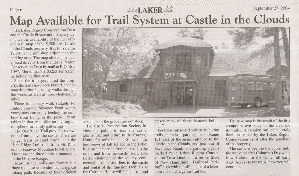
The Castle in the Clouds property is now owned by the Lakes Region Conservation Trust. They have been making a serious effort to make the 25 miles or so of trails on the property easier for people to use (all their trails are open to the public at no charge) by posting trail signs at all trail junctions on the property to help people find their way easily to the half dozen or more (Mt Shaw, Black Snout, Mt Roberts, Faraway Mt, Bald Knob, Oak Ridge, etc) splendid view sites available on the property. Inexpensive trail maps ($2.50) are now available at the Gift Shop at the Castle site or from the Trust office in Meredith. A parking area for hikers is available on Rte 171 about 250 yards east of the entrance to the Castle in the Clouds tourist attraction. Most of the trails are wide carriage roads designed for horsedrawn carriages, so they have very easy grades (but also wind around a lot as they climb through the mountains of this remarkable forested landscape). Many would claim that the view north from the summit of Shaw is the premier view on the property attached is a recently taken photo of the view available from Shaws summit. Last edited by dcr; 10-03-2004 at 08:57 AM. |
|
|
|
|
10-06-2004, 07:19 AM
|
#12 |
|
Senior Member
Join Date: Jul 2002
Location: Rock Haven Lake - West Newfield, ME
Posts: 5,361
Thanks: 374
Thanked 1,044 Times in 490 Posts
|
The Nature Conservancy preserves and maintains several properties in the Lakes Region (Madison, Ossipee, Tamworth, Moultonboro) that include hiking trails. check out their link
 Wingate Shores Preserve at Garland Pond in Moultonboro A 120 acre pond with NO SHORELINE DEVELOPMENT! |
|
|
|
|
10-13-2004, 08:14 PM
|
#13 |
|
Senior Member
Join Date: Jul 2002
Location: Rock Haven Lake - West Newfield, ME
Posts: 5,361
Thanks: 374
Thanked 1,044 Times in 490 Posts
|
|
|
|
|
|
10-14-2004, 12:41 PM
|
#14 |
|
Senior Member

Join Date: Oct 2004
Location: Laconia NH
Posts: 5,512
Thanks: 3,118
Thanked 1,090 Times in 784 Posts
|
There is a cool website that has a list of trails for kids. www.geocaching.com It will turn a trail into a treasure hunt. If you have a GPS you can download the quadrients. The site teaches the kids how to use a GPS as well as get them interested in hiking.
|
|
|
|
|
10-14-2004, 03:44 PM
|
#15 |
|
Senior Member
Join Date: Jun 2004
Posts: 53
Thanks: 1
Thanked 5 Times in 3 Posts
|
I happened by the Nordic Skier in Wolfeboro last weekend and on the counter they had a booklet for $6 listing various trails in the area with map. It indicates that the booklet was put together by a local Teen AMC Project. It looks helpful and easy to follow.
|
|
|
|
|
| Bookmarks |
|
|


 Linear Mode

