

|
|
|
|
|
|||||||
| Home | Forums | Gallery | Webcams | Blogs | YouTube Channel | Classifieds | Calendar | Register | FAQ | Donate | Members List | Search | Today's Posts | Mark Forums Read |
 |
|
|
Thread Tools | Display Modes |
 07-11-2011, 07:42 AM
|
#1 |
|
Senior Member

Join Date: Sep 2007
Location: Lebanon Ct and Rattlesnake Island Since 2007
Posts: 610
Thanks: 180
Thanked 137 Times in 72 Posts
|
Over the 4th, we were discussing when the first house were built on the broads side of Rattlesnake, which houses came first, and what the island looked like prior to houses being built.
I figured I would ask the forum if anyone has this info on timeline and any old pics of what that side looked like in the past. |

|

|
|
07-11-2011, 08:21 AM
|
#2 |
|
Senior Member
Join Date: Jul 2004
Location: Rattlesnake Isl. - Simsbury, CT
Posts: 271
Thanks: 90
Thanked 44 Times in 26 Posts
|
We are on the side facing Treasure/Sleepers. Those lots all started out as seasonal rentals for tents, then later they allowed the renters to erect tent stands, then later small cabins. The rule was that you could then build, but it would have to be removed in 15 or 30 days or something if you lost your lease. A lot of the old cabins are those original structures, with improvements. If you look at the supports holding a lot of these places up, and it is a bit scary how unsecure it really is!
In the 80s, we would drive around the island at sunset, and my grandfather would look at the middle of the broads side and say nobody would ever build there because it was so steep and rocky... |
|
|
|
| The Following User Says Thank You to lakershaker For This Useful Post: | ||
Webbsatwinni (07-11-2011) | ||
|
07-11-2011, 11:46 AM
|
#3 | |
|
Senior Member

Join Date: Jan 2006
Posts: 6,404
Thanks: 719
Thanked 1,379 Times in 955 Posts
|
Quote:
|
|
|
|
|
|
07-11-2011, 03:55 PM
|
#4 |
|
Senior Member

Join Date: Nov 2003
Location: Central NH
Posts: 5,252
Blog Entries: 1
Thanks: 1,447
Thanked 1,349 Times in 475 Posts
|
I would post the actual pictures, but the laptop I'm using isn't being very cooperative. Once you are in Photopost, you can click on the picture to see it in a closer view.
If you were a lessee and built anything on the island, the lessor had the option to purchase what you built at the end of the lease. If the lessor didn't want the items that had been built, they had to be removed or they became the property of the lessor at the termination of the lease. Rattlesnake Island Flyer - front Rattlesnake Island Flyer - right page Rattlesnake Island Flyer - middle pages Rattlesnake Island Flyer - inside right Rattlesnake Island Flyer - inside middle Rattlesnake Island Flyer - inside left A couple years ago I tracked down a former owner from a few lots up to inquire about something. (If memory serves, he owned in the mid 70's.) He was positively shocked when I told him that people actually built on The Broads side of the island. |
|
|
|
| The Following 3 Users Say Thank You to Rattlesnake Gal For This Useful Post: | ||
|
07-11-2011, 04:28 PM
|
#5 | |
|
Senior Member

Join Date: Oct 2004
Location: Laconia NH
Posts: 5,509
Thanks: 3,116
Thanked 1,089 Times in 783 Posts
|
Quote:
He also built a number of A frames on Bear Island. I notice a couple still standing last year! 
__________________
Someday may never be an actual day. |
|
|
|
|
| Sponsored Links |
|
|
|
07-11-2011, 05:06 PM
|
#6 |
|
Senior Member
Join Date: Apr 2005
Location: Wolfeboro, New Hampshire is my home, 24-7-365
Posts: 1,686
Thanks: 1,047
Thanked 336 Times in 189 Posts
|
My earliest remembrance of Rattlesnake were that the only houses on the broads side was a house up towards the west point and one towards the alton side. There was also a couple of rough jetties and a couple of tent platforms. If I remember correctly there was nothing between the measured mile. I thought the same, that no one would ever build there, but I was sure wrong. I remember thinking that when the jetties started to get fixed up that there would be homes there soon. I remember the A-frames on the other side. It seemed like every year at least one was getting "fixed up".
|
|
|
|
|
07-12-2011, 06:45 AM
|
#7 |
|
Senior Member

Join Date: Sep 2004
Posts: 1,254
Thanks: 423
Thanked 366 Times in 175 Posts
|
The number of unbuilt lots is dwindling on the broads side. Some of the lots are owned in common by the association. I suspect it will be a very long time before they are built on but we all know how predictions go. We often have to laugh at just how steep the livin is here but we would not trade it. (OK, we would trade it but no one is offering one of the Governor's Island places
 ) We had a tree that fell this winter. The tree landed so far from the stump, we could not find it for quite a while. I think the tree is about 40 feet away from the stump and the tree is hung up in other trees it fell into. ) We had a tree that fell this winter. The tree landed so far from the stump, we could not find it for quite a while. I think the tree is about 40 feet away from the stump and the tree is hung up in other trees it fell into.Life is good on the edge of a volcano. |
|
|
|
|
07-12-2011, 09:58 AM
|
#8 |
|
Senior Member
Join Date: Nov 2003
Location: Central NH
Posts: 5,252
Blog Entries: 1
Thanks: 1,447
Thanked 1,349 Times in 475 Posts
|
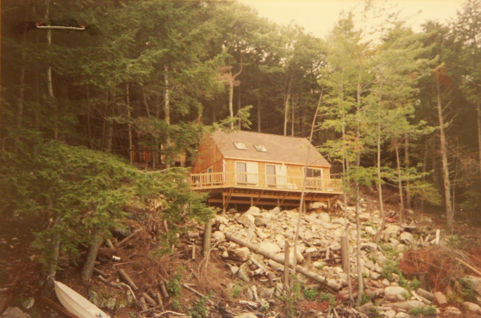 Here is a picture of our camp at what appears to be just after the build, which was 1985 or 1987. (I can never remember the date between our house and the camp.) With a little detective work and time, you can search surnames in www.nhdeeds.com and read the deeds for the land descriptions. It takes time, but you can trace each lot (if you have a name to go by) back to about 1841. A great winter project. Before 1841 you must have to physically go to the Registry of Deeds. Joseph I. Melanson purchased the island in 1950: Book 320, Page 439 |
|
|
|
|
07-13-2011, 05:45 PM
|
#9 |
|
Senior Member
Join Date: Jun 2008
Location: Portsmouth. RI
Posts: 2,231
Thanks: 400
Thanked 460 Times in 308 Posts
|
Here's a picture I took probably in the spring (March..?) of 1971. I was Ice Boating then and we had to take the conditions as they came....which on this occasion were excellent. There was plenty of wind as evidenced by the "Reefs" (Reduced sail) taken in the sails. We had sailed over from Wolfeboro.
This picture was taken on the extreme north end of the island looking off toward Wolfeboro. There was a pile of rocks..shown..on which we presumed was a foundation for a "Daymark"...maybe taken in for the winter. (Daymark: A Non Floating navigational aid.) I'm thinking this location is very close to where the "Rattlesnake CAM" is located today.  NB NBPS: Anybody remember Leigh (Lee) Turner..Wolfeboro..owner of Wolfeboro Inn at the time....He was the guy who called us lowlanders and said..HEY: C'mon up, the ICE is Good. His boat is in the picture.
Last edited by NoBozo; 07-13-2011 at 06:38 PM. |
|
|
|
| The Following 2 Users Say Thank You to NoBozo For This Useful Post: | ||
Jonas Pilot (07-13-2011), Webbsatwinni (07-14-2011) | ||
|
07-13-2011, 07:19 PM
|
#10 |
|
Senior Member
Join Date: Jan 2006
Posts: 6,404
Thanks: 719
Thanked 1,379 Times in 955 Posts
|
I remember Leigh. I knew him very well.
|
|
|
|
|
07-13-2011, 07:49 PM
|
#11 | |
|
Senior Member
Join Date: Apr 2005
Location: Wolfeboro, New Hampshire is my home, 24-7-365
Posts: 1,686
Thanks: 1,047
Thanked 336 Times in 189 Posts
|
Quote:
|
|
|
|
|
|
07-15-2011, 06:44 PM
|
#12 |
|
Senior Member
Join Date: Jun 2008
Location: Portsmouth. RI
Posts: 2,231
Thanks: 400
Thanked 460 Times in 308 Posts
|
Here's another one taken on the SE corner of Rattlesnake..Broads side. Spring 1972..? Check out the ICE. The lake had pretty much broken up and was history..BUT THEN it froze overnight..or two...and we had really nice black ice to sail on. Out in the big lake we only needed about four inches of black ice to sail.
Nb
|
|
|
|
| The Following 3 Users Say Thank You to NoBozo For This Useful Post: | ||
|
07-15-2011, 07:10 PM
|
#13 |
|
Senior Member
Join Date: Jun 2008
Location: Portsmouth. RI
Posts: 2,231
Thanks: 400
Thanked 460 Times in 308 Posts
|
Here we are on our way to Rattlesnake. I was the cowboy..willing to take a chance on thin ice...I went first. Many of the guys were old enough to be my father..and were hesitant to "Go Forth". I convinced them... and they were happy. The ice was about three inches. We would stop every once in awhile to check the thickness. This is done by eyeballing the "Cracks" in the ice...you can judge the thickness by the depth of the cracks. Whenever we stopped we would "Spread Out", so as not to concentrate our weight in one spot.
NB
|
|
|
|
| The Following User Says Thank You to NoBozo For This Useful Post: | ||
Webbsatwinni (07-19-2011) | ||
|
| Bookmarks |
| Thread Tools | |
| Display Modes | |
|
|


 Linear Mode

