

|
|
|
|
|
|||||||
| Home | Forums | Gallery | Webcams | Blogs | YouTube Channel | Classifieds | Calendar | Register | FAQ | Donate | Members List | Search | Today's Posts | Mark Forums Read |
 |
|
|
Thread Tools | Display Modes |
 02-14-2006, 07:02 AM
|
#1 |
|
Senior Member
Join Date: Jul 2004
Posts: 658
Thanks: 121
Thanked 283 Times in 98 Posts
|
Last fall we had a little boating quiz going on another post. I thought that it would be fun to start it over again. If you have an answer to a question give it! If you have a cool question, ask it!
I'll start with a tour of the Lake. Let's start at the Weirs and go from light #1 to light #2 through light #28 in order. (Skip light #15, it is a curve ball). It is a neet trip! Question: What is special about light #20? How can you tell that it is special at night? Misty Blue |

|

|
|
02-14-2006, 07:55 AM
|
#2 |
|
Senior Member

Join Date: Jul 2005
Location: Berlin, Ma / Gilford
Posts: 1,931
Thanks: 445
Thanked 604 Times in 340 Posts
|
Hmmmmmm ...............
I know light # 20 is on the Southern "Broads" side of Parker Island ......... I know light # 20 is NOT a Floating Light ........ I believe (without checking) light # 20 is a "Double Flasher" (special?) at night ........... Is there more ? p.s. .................. love this kind of trivia ..... irt helps teach more interesting aspects of the lake as a boater !! 
|
|
|
|
|
02-14-2006, 12:31 PM
|
#3 |
|
Senior Member
Join Date: Apr 2004
Location: NH
Posts: 2,689
Thanks: 33
Thanked 439 Times in 249 Posts
|
There are at least five other double flashers. FL16 at Middle ground, FL78 at Moose, FL71 at the Witches, FL7 at Six Mile and of course FL1 in Weirs bay. There may be more.
Following the lights in order sounds like fun, but I would do 1-14 then 17,18,16,19,15 then 20-28. While your at it why not 29,30 that's a nice spot. After that you're pretty much repeating, other than a run down Paugus. Rumor has it that 31-38 are the Weirs channel markers and 39 is off Big. Funny, there are no flashing lights in Meredith Bay. |
|
|
|
|
02-14-2006, 08:17 PM
|
#4 |
|
Senior Member
Join Date: Jul 2004
Posts: 658
Thanks: 121
Thanked 283 Times in 98 Posts
|
Cool beans!
Niw try this one... Why is the helm on the Starboard side of most small power boats? Hint: 'Same reason as why every small outboard has it's tiller on the port side. |
|
|
|
|
02-14-2006, 08:19 PM
|
#5 |
|
Senior Member

Join Date: Apr 2004
Location: Dover, NH
Posts: 1,615
Thanks: 256
Thanked 514 Times in 182 Posts
|
I was led to believe it was to offset the small amount of sideways torque induced by the turning propellor?

|
|
|
|
| Sponsored Links |
|
|
|
02-14-2006, 09:28 PM
|
#6 |
|
Senior Member
Join Date: Feb 2006
Location: I'm right here!
Posts: 1,153
Thanks: 9
Thanked 102 Times in 37 Posts
|
The helm is on the Starboard side so that you can easily see the stand-on vessel in a crossing situation at night.
|
|
|
|
|
02-14-2006, 09:52 PM
|
#7 |
|
Senior Member
Join Date: Jul 2004
Posts: 658
Thanks: 121
Thanked 283 Times in 98 Posts
|
Skip and Airwaves, you are both right!
Skip: Remember the emergency procedure for a "hot run" in the torpedo room on the boats? All ahead flank and hard to Port. The torque of the shaft would help the boat to lean to port and make a sharper, faster turn. Airwaves: A Starboard helm allows the helmsman to see the entire "danger zone", 112.5 degrees from the bow to just behind the starboard beam. Note that this is where your green light shines and tells vessels that can see it that you are the give way vessel. Next question: What is "Scope"? How much of it do youd need? I have a eight foot chain between my mooring hawser and my anchor. Why? Misty Blue. |
|
|
|
|
02-14-2006, 10:09 PM
|
#8 |
|
Senior Member
Join Date: Feb 2006
Location: I'm right here!
Posts: 1,153
Thanks: 9
Thanked 102 Times in 37 Posts
|
If I recall, scope is the length of anchor rode between the anchor and boat, I used to have a 3 to 1 scope on my mooring anchor when I moored my boat but I believe the recommendation is 10to 1.
You wisely use the chain on your anchor to keep it lying down and digging into the lake bottom while the anchor rode makes its way to your boat. |
|
|
|
|
02-14-2006, 11:08 PM
|
#9 |
|
Senior Member
Join Date: Feb 2006
Location: I'm right here!
Posts: 1,153
Thanks: 9
Thanked 102 Times in 37 Posts
|
I think I'll throw one out there.
 What is the only ROPE on a powerboat? (Hint, usually only found on boats over 39'.) |
|
|
|
|
02-15-2006, 12:17 AM
|
#10 | |
|
Senior Member

Join Date: Sep 2003
Posts: 1,943
Thanks: 23
Thanked 111 Times in 51 Posts
|
Quote:
 so I'll leave this one unanswered for the moment. I agree that starboard-side helm stations make sense for the reasons stated but it wasn't always this way. I recall one reason I've heard was that it was proper etiquette to board people on the starboard side, so to make docking easier the helm was to starboard. However here's a few boats from the Winni photo vault that say not everyone agreed .... (enjoy) so I'll leave this one unanswered for the moment. I agree that starboard-side helm stations make sense for the reasons stated but it wasn't always this way. I recall one reason I've heard was that it was proper etiquette to board people on the starboard side, so to make docking easier the helm was to starboard. However here's a few boats from the Winni photo vault that say not everyone agreed .... (enjoy)An ole Chris Chraft (port) http://www.winnipesaukee.com/photopo...o=8389&cat=502 Another ole "laker" (port) http://www.winnipesaukee.com/photopo...php?photo=6972 Older yet (starboard) http://www.winnipesaukee.com/photopo...php?photo=7406 Newer '74 (port) http://www.winnipesaukee.com/photopo...php?photo=7432 Even newer I think (port) http://www.winnipesaukee.com/photopo...php?photo=4683 Hmmm, is this one is "bi" ???  http://www.winnipesaukee.com/photopo...php?photo=2578 Lastly, this one is ... I dunno, you tell me http://www.winnipesaukee.com/photopo...php?photo=3493
__________________
Mee'n'Mac "Never attribute to malice that which can be explained by simple stupidity or ignorance. The latter are a lot more common than the former." - RAH |
|
|
|
|
|
02-15-2006, 08:21 AM
|
#11 |
|
Senior Member
Join Date: Jul 2005
Location: Berlin, Ma / Gilford
Posts: 1,931
Thanks: 445
Thanked 604 Times in 340 Posts
|
Let's stick with the Lake for the time being --
Everyone does it at one time or another (after they become somewhat familiar with any body of water) - especially when our/your boat is not configured with the latest & greatest electronics-- they use land/fixed aids to navigate. Question: At night, when departing the Post Office NWZ, heading towards Wiers, what sure fired Aid can you initially depend on (nite or day) to place you on the "roughly" the correct course (and I mean roughly, as you always need to be watching) to line up and pass (visually) FL#3. |
|
|
|
|
02-15-2006, 09:00 AM
|
#12 |
|
Senior Member
Join Date: May 2004
Location: Weirs Beach
Posts: 1,949
Thanks: 80
Thanked 969 Times in 432 Posts
|
I use the Aircraft Collision Avoidance Lights mounted on Gunstock.... well actually I think its located on Mount Rowe.
Woodsy
__________________
The only way to eliminate ignorant behavior is through education. You can't fix stupid. |
|
|
|
|
02-15-2006, 12:04 PM
|
#13 |
|
Senior Member
Join Date: Jul 2005
Location: Berlin, Ma / Gilford
Posts: 1,931
Thanks: 445
Thanked 604 Times in 340 Posts
|
BINGO !!
Give Woodsy the prize ................... 
|
|
|
|
|
02-15-2006, 12:18 PM
|
#14 |
|
Senior Member
Join Date: May 2004
Location: Weirs Beach
Posts: 1,949
Thanks: 80
Thanked 969 Times in 432 Posts
|
I actually use those to determine my bearings quite a bit. They are pretty handy nav aids!
This year will be even better once I get that GPS installed... Woodsy
__________________
The only way to eliminate ignorant behavior is through education. You can't fix stupid. |
|
|
|
|
02-15-2006, 01:03 PM
|
#15 | |
|
Senior Member
Join Date: Apr 2004
Posts: 1,325
Thanks: 5
Thanked 0 Times in 0 Posts
|
Quote:
|
|
|
|
|
|
02-15-2006, 01:05 PM
|
#16 |
|
Senior Member
Join Date: May 2004
Location: Weirs Beach
Posts: 1,949
Thanks: 80
Thanked 969 Times in 432 Posts
|
I don't usually go out when the visibility is reduced by fog... no need to run those risks!
Woodsy
__________________
The only way to eliminate ignorant behavior is through education. You can't fix stupid. |
|
|
|
|
02-15-2006, 01:35 PM
|
#17 | |
|
Senior Member

Join Date: Jul 2004
Posts: 2,974
Thanks: 246
Thanked 736 Times in 438 Posts
|
Quote:
The chain on your mooring is there to resist the chafing that would otherwise part your hawser. Mooring anchors don't need the chain for holding power. |
|
|
|
|
|
02-15-2006, 06:41 PM
|
#18 |
|
Senior Member
Join Date: Feb 2006
Location: I'm right here!
Posts: 1,153
Thanks: 9
Thanked 102 Times in 37 Posts
|
MEE-N-MAC gets to ring the bell!
 The only ROPE on a powerboat is the bell rope, the rope tied to the clapper! There are a couple of other ROPES on sailing vessels that's why I asked about powerboats! The only ROPE on a powerboat is the bell rope, the rope tied to the clapper! There are a couple of other ROPES on sailing vessels that's why I asked about powerboats!Yes, 7 to 1 ratio sounds right. Like I said I used a 3 to 1 ratio on my mooring but I was in protected waters with the current running in one direction (not tidal) I assumed when Misty Blue was talking about his 8 foot anchor chain we was talking about his boat anchor, not his mooring anchor! (sorry for the delay in posting my response, I worked a different shift today and couldn't access the website easily ")
|
|
|
|
|
02-17-2006, 02:44 PM
|
#19 | |
|
Senior Member
Join Date: Apr 2004
Posts: 1,325
Thanks: 5
Thanked 0 Times in 0 Posts
|
Quote:
|
|
|
|
|
|
02-17-2006, 03:30 PM
|
#20 | |
|
Senior Member
Join Date: Apr 2004
Posts: 1,325
Thanks: 5
Thanked 0 Times in 0 Posts
|
Quote:
Is that not their purpose? |
|
|
|
|
|
02-17-2006, 04:56 PM
|
#21 |
|
Senior Member
Join Date: Apr 2004
Location: Dover, NH
Posts: 1,615
Thanks: 256
Thanked 514 Times in 182 Posts
|
Hi GWC....
I dug into it a little deeper, and according to a number of sites this is the story.... In the earlier days of motorboating, most (and still) motors spun the prop clockwise. The torque induced by this spin, while curving a boat gently to the left, also caused a pronounced uplifting of a small boat on the starboard side. The additional weight of the occupant, being placed on the starboard side, was supposed to counteract this minor lifting. The additional benefits with visibility were covered in previous posts. Anyway, there's a lot of different versions of this one effect on numerous sites....I guess in a small boat many years ago I could visualize this theory....of course now-a-days with tabs and modern steering and the overall greater weight and size of boats, it would not be a noticable effect. Anyway, it made for some interesting research! Skip.... |
|
|
|
|
02-17-2006, 05:24 PM
|
#22 |
|
Senior Member

Join Date: Dec 2005
Posts: 150
Thanks: 19
Thanked 38 Times in 23 Posts
|
Don't forget that boats were narrower in the past, this increased the influence of the prop torque leaning the boat over. So, the steering wheel is on the right to allow the driver to sit on the high side so as to maximize his visibility.
__________________
__________________ __________________ So what have we learned in the past two thousand years? "The budget should be balanced, the Treasury should be refilled, public debt should be reduced, the arrogance of Obamunism should be tempered and controlled, and the assistance to foreign lands should be curtailed lest the Republic become bankrupt. People must again learn to work, instead of living on public assistance." . . .Evidently nothing. (Cicero, 55 BC augmented by me, 2010 AD) Last edited by Yankee; 02-20-2006 at 06:18 PM. |
|
|
|
|
02-17-2006, 10:55 PM
|
#23 |
|
Senior Member
Join Date: Jul 2004
Posts: 658
Thanks: 121
Thanked 283 Times in 98 Posts
|
GWC:
If you are thinking obout the small tab, grey/silver in color, behind the prop. it is not to reduce the torque on the boat is to even out the steering. Typical boats propellers (screws) turn clockwise when in forward and counter clockwise when in reverse ( a whole new post). Picture your screw as a big water wheel turning clockwise as you go forward. It would pull your stern to the right thus turning your boat to port. To compensate for this in small craft tabs are placed behind the screw to add a steering effect to the lower unit. Your tab should be adjusted (it takes a 5/16" allen wrench on a Mercruiser) a little bit to starboard. When properly set you can be on plane and let go of the wheel and she should run straight on course. The added benefit is that they are also sacrificial annodes. That is they give up their mass through electron flow saving your outdrive from corrosion. Remember, in fresh water like our beautiful Lake, use magnisium annodes. Zinc annodes are for salt water. 'Hope this helps. 60 days till ice out? Misty Blue. |
|
|
|
|
02-18-2006, 08:55 AM
|
#24 |
|
Senior Member

Join Date: Apr 2004
Location: formerly Winter Harbor, still Wolfeboro
Posts: 1,134
Thanks: 284
Thanked 480 Times in 271 Posts
|
An answer to Dave R: the chain between the lower end of the mooring line and the mooring device (cement block, mushroom ancor, etc) ALSO serves as a shock absorber to the mooring effort. Usually, the weight of the chain will cause a "slack situation" to occur in the mooring system, and, when the wind or wave action exerts pressure on the vessel, away from the mooring device, this "slack situation" will become stretched out and in the process absorb the shock of the vessel against the mooring device. For this reason, it is a good idea to use a heavy chain maybe 10' in length (depending on the water depth and surrounding boats).
|
|
|
|
|
02-18-2006, 12:36 PM
|
#25 | |
|
Senior Member
Join Date: Jul 2004
Posts: 2,974
Thanks: 246
Thanked 736 Times in 438 Posts
|
Quote:
|
|
|
|
|
|
02-19-2006, 04:30 AM
|
#26 |
|
Senior Member
Join Date: Jul 2004
Posts: 658
Thanks: 121
Thanked 283 Times in 98 Posts
|
At sea I read the entire Hornblower (by C.S. Forester) series over and over. The guys had to take me down to the bilge for a little bit of "deprograming".
Any way, Horatio used a trick when anchoring in a storm. He tied a gun barrel to the anchor rhode some distanse from the anchor to keep the line draging the bottom for a better anchr grip. To demonstrate how this works take a piece of velcro and pull the fuzzy side UP from the rough side. It pulls out. Now try pulling not UP but sideways. Wow! That is what makes a plow or a danforth work! New Question: As we all know a sailboat has the "right of way" (I hate that term) over a power boat. But when two sailboats are aproaching each other with a risk of collision who is the "stand on" vessel? |
|
|
|
|
02-19-2006, 12:04 PM
|
#27 |
|
Senior Member

Join Date: Feb 2003
Location: Cow Island
Posts: 914
Thanks: 602
Thanked 193 Times in 91 Posts
|
A. The sailboat on a starboard tack (wind coming from it's starboard) has the right of way and is the stand-on vessel.
Q. What is the reference point for Five and Six mile Islands and what is the origin of the name of that reference point? |
|
|
|
|
02-19-2006, 01:12 PM
|
#28 | |
|
Senior Member
Join Date: Apr 2004
Posts: 1,325
Thanks: 5
Thanked 0 Times in 0 Posts
|
Quote:
|
|
|
|
|
|
02-19-2006, 04:39 PM
|
#29 | |
|
Senior Member
Join Date: Feb 2006
Location: I'm right here!
Posts: 1,153
Thanks: 9
Thanked 102 Times in 37 Posts
|
Quote:
|
|
|
|
|
|
02-19-2006, 04:47 PM
|
#30 | |
|
Senior Member
Join Date: Apr 2004
Posts: 1,325
Thanks: 5
Thanked 0 Times in 0 Posts
|
Quote:
|
|
|
|
|
|
02-19-2006, 04:55 PM
|
#31 |
|
Senior Member
Join Date: Feb 2006
Location: I'm right here!
Posts: 1,153
Thanks: 9
Thanked 102 Times in 37 Posts
|
That's one!
|
|
|
|
|
02-19-2006, 09:55 PM
|
#32 |
|
Senior Member
Join Date: Jul 2004
Posts: 658
Thanks: 121
Thanked 283 Times in 98 Posts
|
The power boat is the stand on vessel if it is being overtaken by a sailboat. For example, if you are at headway speed and being oventaken by a Hobie Cat, you are the stand on vessel. Note, this is in the NavRules but may not apply in NH. We like to make up our own rules because we are special or something.
Real good queston Waves! New question for all of you coffee table navigators out there: We are talking distance here... What is the difference between any given degree of LATITUDE and any given degree of LONGITUDE? Extra credit: What is a RHUMB LINE? If you sail one northward where will you end up. Hint: Loxodrome. It's OK to use your CHAPMAN'S! Misty Blue |
|
|
|
|
02-20-2006, 09:21 AM
|
#33 | |
|
Senior Member
Join Date: Apr 2004
Location: Dover, NH
Posts: 1,615
Thanks: 256
Thanked 514 Times in 182 Posts
|
Quote:
TITLE XXII NAVIGATION; HARBORS; COAST SURVEY CHAPTER 270-D BOATING AND WATER SAFETY ON NEW HAMPSHIRE PUBLIC WATERS Section 270-D:2 270-D:2 General Rules for Vessels Operating on Water. I. Vessels shall be operated at headway speed only, while passing under all bridges. II. (a) It shall be the duty of each vessel to keep to the right when vessels are approaching each other head on. (b) When the courses of vessels are so far to the starboard of each other as not to be considered as approaching head on, they shall keep to the left. III. When vessels are crossing courses or approaching each other in an oblique direction which may involve risk of collision, the vessel which has the other on its starboard side shall keep out of the way of the other, allowing the latter vessel to keep its course and speed. IV. When vessels are running in the same direction and the vessel which is astern desires to pass the other, it shall do so only when sufficient distance between the vessels is available to avoid danger of collision, and at such a speed that its wake will not endanger the boat being passed or its occupants. No person operating a vessel shall abruptly change its course without first determining that it can safely be done without crossing immediately ahead of another vessel. V. If, when vessels are approaching each other, either vessel fails to understand the course or intention of the other from any cause, such vessel or vessels shall immediately slow to a speed barely sufficient for steerage until the vessels have safely passed each other. If it appears the danger of collision is imminent both vessels shall stop or reverse and not proceed until such danger has been averted. VI. (a) To provide full visibility and control and to prevent their wake from being thrown into or causing excessive rocking to other boats, barges, water skiers, aquaplanes or other boats, rafts or floats, all vessels shall maintain headway speed when within 150 feet from: (1) Rafts, floats, swimmers. (2) Permitted swimming areas. (3) Shore. (4) Docks. (5) Mooring fields. (6) Other vessels. (b) These requirements shall not apply when: (1) Starting skiers from shore, docks or floats, as long as neither the boat nor the skier is endangering the life or safety of any person. (2) A vessel is in the federal deepwater shipping channel of the Piscataqua River between navigation buoys R2, Wood Island at the mouth of the river and R12, opposite the Sprague Terminal. (c) The operator of a towing boat shall be responsible for compliance with this paragraph. (d) The requirements of RSA 270-D:2, VI(a)(3) shall not apply to a vessel in the waters of the Androscoggin River from the Errol Dam to Umbagog Lake or in the waters of the Magalloway River within the state of New Hampshire. VI-a. [Repealed.] VII. When a vessel is given the right-of-way, such vessel shall hold its course and maintain such speed as the circumstances prudently permit. VIII. When a vessel is required to keep out of the way of another, it shall, if necessary, slacken its speed, stop, or reverse, and avoid crossing ahead of any other vessel. IX. Canoes, rowboats and sailboats shall be given the right-of-way. This requirement shall not be construed to allow deliberate impediment of motorboats by canoes, rowboats or sailboats. |
|
|
|
|
|
02-20-2006, 03:37 PM
|
#34 | |
|
Senior Member
Join Date: Feb 2003
Location: Cow Island
Posts: 914
Thanks: 602
Thanked 193 Times in 91 Posts
|
Quote:
"Center Harbor gets its name from two sources: from its location, centered between Meredith and Moultonborough Harbors, and also for the Senter family, who were owners of a large amount of property in the area." |
|
|
|
|
|
02-22-2006, 08:28 PM
|
#35 | |
|
Senior Member
Join Date: Sep 2003
Posts: 1,943
Thanks: 23
Thanked 111 Times in 51 Posts
|
Quote:
 ps - I'll say you'd end up ashore
__________________
Mee'n'Mac "Never attribute to malice that which can be explained by simple stupidity or ignorance. The latter are a lot more common than the former." - RAH |
|
|
|
|
|
02-22-2006, 08:31 PM
|
#36 |
|
Senior Member
Join Date: Jul 2004
Posts: 658
Thanks: 121
Thanked 283 Times in 98 Posts
|
Hey...We are having some fun here! Try these:
What type of line would you use to tie up your boat to a dock...and why? What type of line would you use to anchor your boat...and why? What type of line would you use for standing and running rigging on your sailboat...and why? What type of line would you use for water skiing and life rings...and why? What type of line would you use to pick up a "dollie" at the Bad Moose....And Why??? Misty Blue |
|
|
|
|
02-22-2006, 08:42 PM
|
#37 | |
|
Senior Member
Join Date: Apr 2004
Location: Dover, NH
Posts: 1,615
Thanks: 256
Thanked 514 Times in 182 Posts
|
Quote:
I'd take a stab at the last question, but my wife is in the next room....never know when she's going to pop in and check on me! Skip |
|
|
|
|
|
02-22-2006, 09:01 PM
|
#38 | |||||
|
Senior Member
Join Date: Sep 2003
Posts: 1,943
Thanks: 23
Thanked 111 Times in 51 Posts
|
Quote:
Quote:
Quote:
Quote:
Quote:
{runner-up - "Hey that's a nice shirt ! Can I talk you out of it ?"}
__________________
Mee'n'Mac "Never attribute to malice that which can be explained by simple stupidity or ignorance. The latter are a lot more common than the former." - RAH |
|||||
|
|
|
|
02-22-2006, 09:07 PM
|
#39 | |
|
Senior Member
Join Date: Apr 2004
Location: Dover, NH
Posts: 1,615
Thanks: 256
Thanked 514 Times in 182 Posts
|
Quote:
|
|
|
|
|
|
02-22-2006, 09:31 PM
|
#40 | |
|
Senior Member
Join Date: Sep 2003
Posts: 1,943
Thanks: 23
Thanked 111 Times in 51 Posts
|
Quote:
ps - "Mee" would smirk and say "$50, you better go back to the ATM !" Most days I feel like Rodney Dangerfield ...
__________________
Mee'n'Mac "Never attribute to malice that which can be explained by simple stupidity or ignorance. The latter are a lot more common than the former." - RAH |
|
|
|
|
|
02-22-2006, 10:43 PM
|
#41 |
|
Senior Member
Join Date: Jul 2004
Posts: 658
Thanks: 121
Thanked 283 Times in 98 Posts
|
Lattitude:
Think of a ladder (lattidude, get it?). What do we know about the rungs of a ladder? They are parralel and eqidistantant. There are 180 degrees of lattidude north of the equator and 180 degrees south (below) the equator. Each is devided into 60 minutes of lattidude. Each minute, by deffinition, is one nautical mile. Thats why metrics don't work on a chart. They are always the same. Longitude is way different. The lines of longitude arn't like the rungs of a ladder they are like the segments of an orange. Picture this... the distace from one segment of an orange at it's middle is about 1/2 inch. Travel up or down the orange and measure the distance and it becomes less and less until it is zero at the top and bottom of the orange. ie. the north and south poles! Now for the rhumb line.... If you were to plot a course and sail let's say at a 45 degree angle north on a flat chart, usually a mercator projection, you would move up and across at a 45 degree unchanging angle. But the earth is round, just ask Columbus. If you try this on a sphere you will start to spiral up the globe and finially screw yourself up to the north pole and see the magic kingdome. This is the Rhumb line or loxodrome! Use that to impress your friends at the Yacht Club! Misty Blue. |
|
|
|
|
02-23-2006, 12:14 AM
|
#42 | |
|
Senior Member
Join Date: Sep 2003
Posts: 1,943
Thanks: 23
Thanked 111 Times in 51 Posts
|
Quote:
http://en.wikipedia.org/wiki/Rhumb_line ps - lattidude ? Isn't that mcdude's coffee drinking brother from Seattle ?
__________________
Mee'n'Mac "Never attribute to malice that which can be explained by simple stupidity or ignorance. The latter are a lot more common than the former." - RAH |
|
|
|
|
|
02-23-2006, 12:24 AM
|
#43 | |
|
Senior Member
Join Date: Apr 2004
Posts: 1,325
Thanks: 5
Thanked 0 Times in 0 Posts
|
Quote:
|
|
|
|
|
|
02-23-2006, 12:39 AM
|
#44 |
|
Senior Member
Join Date: Jul 2004
Posts: 658
Thanks: 121
Thanked 283 Times in 98 Posts
|
Wow MnM:
You blew me away with that post! I thought that I used to know what I was talking about and the Rhumb line has always been a good way to win free drinks at the Hyannis Yacht club! (A place that I have been thrown out of, but that is a whole different story!) You guys are too much! Misty Blue |
|
|
|
|
02-23-2006, 01:06 PM
|
#45 |
|
Senior Member

Join Date: Apr 2004
Posts: 176
Thanks: 19
Thanked 14 Times in 11 Posts
|
If you follow a rhumb line north from any point on earth you will end up at the geographic north pole, but watch out for land masses and ice bergs!
Don't try this with a magnetic compass, you'll end up somewhere in the Canadian Arctic. As a side note, a magnetic compass doesn't really work anywhere near (hundreds of miles) the magnetic north pole, as the magnetic field lines it is trying to align with are nearly vertical, and the pointer or card tries to point straight down. While flying over northern Greenland in a helicopter, I noticed that all the mag compass could do was spin in circles!
|
|
|
|
|
02-23-2006, 07:08 PM
|
#46 |
|
Senior Member
Join Date: Sep 2003
Posts: 1,943
Thanks: 23
Thanked 111 Times in 51 Posts
|
Since we've touched on island names already perhaps we can continue on that line for a bit. If this takes off perhaps it can be split and put into General Discussion. So we've previously (on the forum) taked about how Rattlesnake I and Becky's Garden and Cow I got their names. Just above we've talked about how 6 Mile island got it's name but how did Far Ozone get it's name ? (I don't know). Little 6 Mile Island makes sense but Far Ozone ? So who knows the story ?
__________________
Mee'n'Mac "Never attribute to malice that which can be explained by simple stupidity or ignorance. The latter are a lot more common than the former." - RAH |
|
|
|
|
02-23-2006, 10:53 PM
|
#47 |
|
Senior Member
Join Date: Feb 2006
Location: I'm right here!
Posts: 1,153
Thanks: 9
Thanked 102 Times in 37 Posts
|
I've got no clue, maybe a lightening strike? I know at my condo a friend was in the bathroom when lightening hit at the airport and he peed on the wall, we blamed the smell the rest of the night on ozone!
|
|
|
|
|
02-24-2006, 06:56 AM
|
#48 |
|
Senior Member
Join Date: Jul 2004
Posts: 658
Thanks: 121
Thanked 283 Times in 98 Posts
|
MnM:
Great idea! I don't know about Far Ozone either but I may be able to contact the owner of Little Six Mile. They may have an idea. Question: After you have refuled your inboard or I/O boat what is the last thing you do prior to starting up? BTW Island Ho...you must have done some cool stuff! Misty Blue |
|
|
|
|
02-24-2006, 07:56 AM
|
#49 |
|
Senior Member
Join Date: Jul 2005
Location: Berlin, Ma / Gilford
Posts: 1,931
Thanks: 445
Thanked 604 Times in 340 Posts
|
After fueling you should ALways Always Always run your blower to exhaust possible fumes below deck (engine compartment) if the boat being fueled is an Inboard or I/O !!
Question: how many islands are accessible by bridge and what are their names? |
|
|
|
|
02-24-2006, 08:02 AM
|
#50 |
|
Senior Member

Join Date: Apr 2004
Posts: 5,075
Thanks: 215
Thanked 903 Times in 509 Posts
|
Governors,Blackcat,and Long are 3.
__________________
SIKSUKR |
|
|
|
|
02-24-2006, 10:23 AM
|
#51 |
|
Deceased Member

Join Date: Jul 2002
Posts: 1,701
Thanks: 115
Thanked 25 Times in 13 Posts
|
There are 6 Governors,Black Cat, Long, Oak, Worcester,plus 1 more I can't remember.
|
|
|
|
|
02-24-2006, 11:11 AM
|
#52 | |
|
Senior Member
Join Date: Apr 2004
Location: NH
Posts: 2,689
Thanks: 33
Thanked 439 Times in 249 Posts
|
Quote:
If you count foot bridges there may be a few more. Depending on what accessible means you could include Steamboat and Birch. |
|
|
|
|
|
02-24-2006, 11:41 AM
|
#53 |
|
Deceased Member
Join Date: Jul 2002
Posts: 1,701
Thanks: 115
Thanked 25 Times in 13 Posts
|
Thats it. How could I forget Chrismas?
|
|
|
|
|
02-24-2006, 12:52 PM
|
#54 | |
|
Senior Member

Join Date: Jul 2002
Location: Massachusetts
Posts: 332
Thanks: 0
Thanked 242 Times in 81 Posts
|
Quote:
|
|
|
|
|
|
02-24-2006, 01:05 PM
|
#55 | |
|
Senior Member
Join Date: Sep 2003
Posts: 1,943
Thanks: 23
Thanked 111 Times in 51 Posts
|
Quote:
ps - Pepper ! get your mind out of the gutter ! 
__________________
Mee'n'Mac "Never attribute to malice that which can be explained by simple stupidity or ignorance. The latter are a lot more common than the former." - RAH |
|
|
|
|
|
02-24-2006, 01:12 PM
|
#56 |
|
Senior Member
Join Date: Apr 2004
Location: NH
Posts: 2,689
Thanks: 33
Thanked 439 Times in 249 Posts
|
Well there's one here between Half Mile and Hog? Islands. There looks like a old bridge between Hog and the mainland.
http://local.live.com/default.aspx?v...&scene=1661355 There's another two here in Blackey Cove, connnecting Havard? and another island to the mainland. http://local.live.com/default.aspx?v...&scene=1661355 BTW thanks Bizer for making a great chart. |
|
|
|
|
02-24-2006, 01:17 PM
|
#57 | |
|
Senior Member
Join Date: Apr 2004
Location: NH
Posts: 2,689
Thanks: 33
Thanked 439 Times in 249 Posts
|
Quote:
I think this was on the boating test. |
|
|
|
|
|
02-24-2006, 05:58 PM
|
#58 | |
|
Senior Member
Join Date: Feb 2006
Location: I'm right here!
Posts: 1,153
Thanks: 9
Thanked 102 Times in 37 Posts
|
Quote:
Yes, you should ALWAYS, ALWAYS, ALWAYS run the blower prior to starting the engine, not only after refueling but in all cases! |
|
|
|
|
|
02-28-2006, 02:30 AM
|
#59 |
|
Senior Member
Join Date: Jul 2004
Posts: 658
Thanks: 121
Thanked 283 Times in 98 Posts
|
JRC you get the banana!
As you all know everything about a boat is expensive. That is except the tool used to insure that your boat is free of explosive gasses. It is right between your eyes. Yup, the old sniff test is not only very accurate but also free! As for the blower... When we teach the boating class we always teach by the book. That is all electronics, including the blower are to be off. And yes this is on the test. I, however disagree. The whole idea of venting is to keep the space below the Lower Explosive Limit (LEL). If you run the blower while refueling you are constantly removing any explosive gasses and keeping the space below LEL. If you refuel and there is an explosive atmosphere in the space when you start the blower you will be closing a 12 volt switch (spark?) and starting a 12 volt DC motor (spark?) I know what the book says but I just don't buy it. New question: What things make a type I PFD different than a type II PFD? Misty Blue. |
|
|
|
|
02-28-2006, 01:30 PM
|
#60 | |
|
Senior Member
Join Date: Feb 2006
Location: I'm right here!
Posts: 1,153
Thanks: 9
Thanked 102 Times in 37 Posts
|
Quote:
Yes, you nose (assuming you don't have a cold! ) is the best tool to use, if you smell gasoline vapors don't start the engine!Type I is commonly called the May West. It's used offshore by the navy and requires training to use. I believe type II is the type of offshore vest used by recreational boaters because it doesn't require training. If I'm not mistaken Type I is not CG approved for recreational boaters for that reason while Type II is. My experiences have been limited to Types III and IV |
|
|
|
|
|
02-28-2006, 01:50 PM
|
#61 | |
|
Senior Member
Join Date: Apr 2004
Location: Dover, NH
Posts: 1,615
Thanks: 256
Thanked 514 Times in 182 Posts
|
Quote:
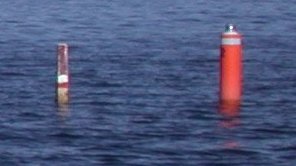
......Anyway, these are the big, bulky offshroe type jackets, similar to what you see sailors wearing in those old WWII movies.The Type II PFD is less buoyant than the Type I and better utilized in calmer waters. It will turn some unconcious victims face up....These are the lighter (usually orange) type jackets that almost everyone buys at Walmart and tosses out-of-sight in a (hopefully) convenient spot onboard! Either type is an approved (Coast Guard) device in NH towards your PFD carrying requirement. Next Question: On Lake Winnipesaukee (or any NH lake) what is the difference between a red-over-white spar buoy versus a black-over-white spar buoy? Skip |
|
|
|
|
|
02-28-2006, 03:25 PM
|
#62 |
|
Senior Member
Join Date: Apr 2004
Location: NH
Posts: 2,689
Thanks: 33
Thanked 439 Times in 249 Posts
|
I know this one is on the test. On the lake I just know which side to pass because I've been by them so many times before. On tests or strange places I remember that it's hot (red) in the south-west.
So pass red top spars on the south when traveling east or west, and on the west when travel north or south. Black tops are of course the opposite. On Winnipesukee at least, one color of these spars has a stripe. This can make it easier to tell them apart in low-light conditions. Which one is it? My memory aid on this one is related to a beverage. BTW Finding the safe side of a spar bouy using only a compass is not always as unambiguous as it sounds, I still use a chart in strange areas. Last edited by jrc; 02-28-2006 at 06:22 PM. |
|
|
|
|
02-28-2006, 04:36 PM
|
#63 | |
|
Senior Member
Join Date: Jul 2005
Location: Berlin, Ma / Gilford
Posts: 1,931
Thanks: 445
Thanked 604 Times in 340 Posts
|
Quote:
Case in point - you actually split between two black tops when passing FL#30 on a course away from Mark Isl toward safe water between Jolly & Camp (and vise versa) and NOT changing compass heading I might add for those who want to get picky -- I have checked the chart a thousand times to be sure!! This little quirk has baffled me for years!! I'm sure there are others similar - this one happens to be on one of our regular routes |
|
|
|
|
|
02-28-2006, 05:22 PM
|
#64 |
|
Senior Member
Join Date: Apr 2004
Posts: 1,325
Thanks: 5
Thanked 0 Times in 0 Posts
|
The first contrary buoy that comes to mind is FL #1, Black Spar accompanies.
Might as well start at the beginning...
|
|
|
|
|
02-28-2006, 07:48 PM
|
#65 | |
|
Senior Member
Join Date: Feb 2003
Location: Cow Island
Posts: 914
Thanks: 602
Thanked 193 Times in 91 Posts
|
Quote:
Airwaves hit the key point regarding avoiding drawing in fumes during refueling. |
|
|
|
|
|
03-01-2006, 04:51 AM
|
#66 |
|
Senior Member
Join Date: Jul 2004
Posts: 658
Thanks: 121
Thanked 283 Times in 98 Posts
|
OK Airwaves, you have sold me on the blower issue.
Hey Skip, want to hear a good one? The Navy Kapoks are not Coast Guard approved! Go figure! A Type I PFD has more bouyency than a Type II (I think 17.5# but don't remember) it is reverseable so an untrained person can put it on easily and has SOLAS reflection. Both Types I and II should bring an unconsious victim upright. Now let's here one for the NHMP. They do a great job at maintaining the State's ATONS. It is a big job and they keep them up well and repair them quickly when they are damaged. The bouyage system used on the coast is quite different than the system (some times called the "cardinal system" because it uses the cardinal points of the compass N,E,S,W) that we use on our lakes. The international system uses ATONs like Nuns and Cans to show the safe passages. It is really developed for large craft either returning from or going out to sea. The NH system is used not to show you where you can be but rather it identifies the hazards and tells you where you shouldn't be. A lot of my CG buddies don't like our system but I think that it is ideal for our situation. As for the colors, I like to remember that we live in the North East and a famous tree from our area is the white birch. It is White with Black trim. When you see a spar that is White with Black you must stay either North or East of it. Misty Blue. |
|
|
|
|
03-01-2006, 10:45 AM
|
#67 |
|
Senior Member
Join Date: Apr 2004
Posts: 5,075
Thanks: 215
Thanked 903 Times in 509 Posts
|
Ok,here is how I remembered which way to navigate the spar bouys.Black is at the beginning of the alphabet along with north and east.Red is later along with south and west.Crazy,but it worked for me!
__________________
SIKSUKR |
|
|
|
|
03-01-2006, 01:16 PM
|
#68 | |
|
Senior Member
Join Date: Jul 2004
Posts: 2,974
Thanks: 246
Thanked 736 Times in 438 Posts
|
Quote:
|
|
|
|
|
|
03-01-2006, 01:30 PM
|
#69 |
|
Deceased Member
Join Date: Jul 2002
Posts: 1,701
Thanks: 115
Thanked 25 Times in 13 Posts
|
FL#1 is at Weirs Beach
|
|
|
|
|
03-01-2006, 01:49 PM
|
#70 | |
|
Senior Member
Join Date: Jul 2004
Posts: 2,974
Thanks: 246
Thanked 736 Times in 438 Posts
|
Quote:
Thanks!That's the marker nearish to the north east shore that you pass to the southwest of, correct? As far as I know, It just marks a shoal that's likely only a problem for really deep draft vessels. Why is it black and white??? Hmmm. Never thought about it, just awlays went around it on the outside because that's what my chart says to do. |
|
|
|
|
|
03-02-2006, 08:02 AM
|
#71 |
|
Senior Member
Join Date: Jul 2005
Location: Berlin, Ma / Gilford
Posts: 1,931
Thanks: 445
Thanked 604 Times in 340 Posts
|
Dave R -- you are absolutely correct -- Our cottage is along the "shoal" shoreline -- In all the years of boating on the lake I have never found a "Hazard" i.e rock / whatever along that area.
The marker (I believe) is set in the present location to accomplish 3 things - (1) Mark safe deep water passage -- for as soon as your "behind" FL#1 water depth jumps from some 30+ ft to 4 - 8 ft depending -- plenty of water for 80% of the boats on the lake. (2) Gives the Mount a Nav position (again, deep water) (3) Give the captian of the Mount a positional reminder of When to "blow the horn" when returning to Wiers I would however caution folks from "cutting the corner" in the Holt's Pt area. I know of at least two boats that have shortened their outdrive (hit hard) in that area --- there must be some sort of "old" wall/ breakwater in that area -- I have searched (above water) but never found -- the fact remains two didn't make it. |
|
|
|
|
03-02-2006, 08:56 AM
|
#72 |
|
Senior Member
Join Date: Apr 2004
Location: NH
Posts: 2,689
Thanks: 33
Thanked 439 Times in 249 Posts
|
This marker shows one of the ambiguities of our system. When leaving the Weirs channel for the Eagle Island channel you will be traveling about Northeast. If you're little more north than east, then the rules say pass east of black marker, which is the wrong side. If you're travelling more easterly, then go north of the marker and everything is fine.
As people have said this marker is usually no big deal unless you're the Mount or another deep draft vessel. There are other spots that are as ambiguous, the black marker SE of Treasure Island, comes to mind. Nobody got my which spar marker has a stripe question. So I'll have to answer it myself. On the newer round plastic spars, the red one has a stripe. |
|
|
|
|
03-02-2006, 10:03 AM
|
#73 | |
|
Senior Member
Join Date: Apr 2004
Location: Dover, NH
Posts: 1,615
Thanks: 256
Thanked 514 Times in 182 Posts
|
Quote:
Do I receive half credit for that????
|
|
|
|
|
|
03-02-2006, 10:15 AM
|
#74 |
|
Senior Member
Join Date: Jul 2004
Posts: 2,974
Thanks: 246
Thanked 736 Times in 438 Posts
|
Now that I look at it on the chart, I think the color on the spar is perfect.
|
|
|
|
|
03-02-2006, 01:18 PM
|
#75 | |
|
Senior Member
Join Date: Apr 2004
Location: NH
Posts: 2,689
Thanks: 33
Thanked 439 Times in 249 Posts
|
Quote:
http://www.redstripebeer.com/ |
|
|
|
|
|
03-02-2006, 01:38 PM
|
#76 |
|
Senior Member
Join Date: Jul 2005
Location: Berlin, Ma / Gilford
Posts: 1,931
Thanks: 445
Thanked 604 Times in 340 Posts
|
JRC -- never noticed the "stripe" -- it's not reflective tape is it?
Also -- could you elaborate on the ambiguous marker near Treasure? That one I'm not familiar with (opposite side of the lake from my "normal" boating). So far we have blak tops near FL#30 ----- FL#1 is arguable one way or the other ---- Any more??? Finally -- Dave R -- thats neat posting part of the Nav map, "how'd ya do dat"? Scan a small section of the map in? |
|
|
|
|
03-02-2006, 02:08 PM
|
#77 |
|
Deceased Member
Join Date: Jul 2002
Posts: 1,701
Thanks: 115
Thanked 25 Times in 13 Posts
|
Phantom it was me that first posted the map and was going to post one of Treasure Island when I realized that is breaking copyright laws
Yes it was scaned I will delete Bizer please don't sue.
|
|
|
|
|
03-02-2006, 02:33 PM
|
#78 | |
|
Senior Member
Join Date: Jul 2004
Posts: 2,974
Thanks: 246
Thanked 736 Times in 438 Posts
|
Quote:
|
|
|
|
|
|
03-02-2006, 02:43 PM
|
#79 | ||
|
Senior Member
Join Date: Apr 2004
Posts: 1,325
Thanks: 5
Thanked 0 Times in 0 Posts
|
Quote:
Quote:
According to JRC's intro, one would pass to the North (that would be okay) "when traveling east or west" and to the East (Oops- found bottom) "when travel north or south." Still a head-scratcher...
|
||
|
|
|
|
03-02-2006, 02:57 PM
|
#80 | |
|
Deceased Member
Join Date: Jul 2002
Posts: 1,701
Thanks: 115
Thanked 25 Times in 13 Posts
|
Quote:
|
|
|
|
|
|
03-02-2006, 04:03 PM
|
#81 | ||
|
Senior Member
Join Date: Apr 2004
Location: NH
Posts: 2,689
Thanks: 33
Thanked 439 Times in 249 Posts
|
Quote:
Quote:
|
||
|
|
|
|
03-02-2006, 06:05 PM
|
#82 |
|
Deceased Member
Join Date: Jul 2002
Posts: 1,701
Thanks: 115
Thanked 25 Times in 13 Posts
|
I thought the black spars had stripes also but they don't but the red ones do.
OK I learned something |
|
|
|
|
03-02-2006, 10:29 PM
|
#83 | |
|
Senior Member
Join Date: Jul 2002
Location: Massachusetts
Posts: 332
Thanks: 0
Thanked 242 Times in 81 Posts
|
Quote:
 As for the ambiguous buoys, there will always be a problem when the buoy is southeast (or northwest) of a boating hazard. The buoy southeast of Treasure Island could be red because the bulk of the traffic passes to the south. However there are others: Southeast of Spindle Point, southeast of Ozone, southeast of Long Point, southeast of Sandy Island, light #3, etc, etc. Traffic passing these buoys in a north/south path should pass to the east (so the buoy should be black). Those passing on an east/west path should pass to the south (so the buoy should be red). The same could be said for buoys northwest of boating hazards like light #1, #2, northwest Varney Point, #66, #49, the black buoy 100m west of light #71, and others. |
|
|
|
|
|
03-03-2006, 06:30 AM
|
#84 | |
|
Senior Member
Join Date: Apr 2004
Location: Dover, NH
Posts: 1,615
Thanks: 256
Thanked 514 Times in 182 Posts
|
Quote:
Skip |
|
|
|
|
|
03-04-2006, 03:18 PM
|
#85 |
|
Senior Member
Join Date: Feb 2003
Location: Cow Island
Posts: 914
Thanks: 602
Thanked 193 Times in 91 Posts
|
The bottom line on solving the buoy color ambiguity is to look at the chart to see the side of safe passage. I never trust color alone and always check charts continuously when in an area I'm not 100% familiar with. There are many questionable areas....Pistol Island is one that comes to mind and another area heading up Moultonborough bay where the colors seem to reverse. This is because there is a huge (18') submerged rock in 20' of water in the middle of the passage. You can never check your chart too often.
|
|
|
|
|
03-04-2006, 09:24 PM
|
#86 |
|
Senior Member
Join Date: Jul 2004
Posts: 658
Thanks: 121
Thanked 283 Times in 98 Posts
|
I agree with Bizer.
I would love to see the black and white bouys changed to a black and white "can" shape about the size of the lighted bouys and the red and white ones changed to red and white "nun" shaped bouys. This would make them much easier to identify. Have you ever asked yourself " is that one red or black?" I have. And I would be willing to throw in a surcharge in the registration to pay for it. But which way is north? New question: When you look at the MAGNETIC compass in your boat it may not be reading truely north. There are two things causing errors in it's reading. What are they? Misty Blue |
|
|
|
|
03-04-2006, 11:53 PM
|
#87 | |
|
Deceased Member

Join Date: Nov 2002
Location: 1/2 way between Boston & Providence
Posts: 573
Blog Entries: 3
Thanks: 32
Thanked 55 Times in 22 Posts
|
Quote:
Then there is magnetic deviation. Almost anything metallic on your boat can influence your compass needle. The motor, wiring, other metal can all make a difference and possibly cause false readings. Some compasses have little adjustments you can make to compensate for magnetic variation. Some people have placed small magnets strategically around their compass to even out irregularities from metal in the boat. I don't have a compass mounted on my boat anymore. They kept breaking and, after several units and an expired warranty, I gave up on it. Besides, to use it you often need to know where you are and where you are going. If I already know that then why do I need the compass ?Did I come close Misty?
__________________
 Amateur HAM Radio What is it? You'll be surprised. When all else fails Ham Radio still works. Shriners Hospitals providing specialized care for children regardless of ability to pay. Find out more or refer a patient. |
|
|
|
|
|
03-05-2006, 09:18 PM
|
#88 |
|
Senior Member
Join Date: Jul 2004
Posts: 658
Thanks: 121
Thanked 283 Times in 98 Posts
|
Right on Sea Que!
The inherent errors in a magnetic compass are Variation and Deviation (no jokes folks, it's a technical term!). Variation is the difference between true north (where Santa lives,and yes I have seen it) and this big blob of iron which lives up in the Queen Elizabeth islands. This blob moves a little bit every day to the west. For expmple, when Jesus walked the earth (or water or whatever) magnetic north was in Scandinavia! Today our variation is about 16 degrees west in NH. In Florida magnetic and true north line up and there is no variation! Deviation changes like crazy depending on your boat's heading. It is the change in your compass reading caused by metal in your boat, like engines and anchors, etc. When you are heading north the engine is directly behind you and may not influence the compass. When you are heading east or west it is perpendicular to the magnetic influence of the pole and pulls your compass either left or right. To compensate for this you should make up a "Deviation table" which can be used to mathematically correct the compass for each heading. OK for the Queen Mary but really not necessary here on the Lake. Now pull out your Bizer or Duncan and take a look at the "Compass Rose". It is not the name of a boat owned by a Yachting wannabee but a depiction of a compass on your chart. It is full of information. New question: What information is on the compass rose? Misty Blue |
|
|
|
|
03-05-2006, 09:43 PM
|
#89 | |
|
Senior Member
Join Date: Apr 2004
Posts: 1,325
Thanks: 5
Thanked 0 Times in 0 Posts
|
Quote:
http://www.ruf.rice.edu/~feegi/compass.html http://www.gisnet.com/notebook/comprose.html http://www.ruf.rice.edu/~feegi/chart2.html  |
|
|
|
|
|
03-06-2006, 11:08 AM
|
#90 |
|
Senior Member

Join Date: Apr 2004
Location: Wolfeboro
Posts: 521
Thanks: 10
Thanked 29 Times in 15 Posts
|
I believe that the compass on my Garmin GPS takes it setting from a satellite position. Is this all true? It is different from the compass by a few degrees. This is in Florida.
__________________
Home Permanently in NH
|
|
|
|
|
03-06-2006, 03:00 PM
|
#91 | |
|
Senior Member
Join Date: Jul 2004
Posts: 2,974
Thanks: 246
Thanked 736 Times in 438 Posts
|
Quote:
|
|
|
|
|
|
03-06-2006, 10:08 PM
|
#92 |
|
Senior Member
Join Date: Sep 2003
Posts: 1,943
Thanks: 23
Thanked 111 Times in 51 Posts
|
I don't have a Bizer (or even his chart
) in front of me right now but in addition to what GWC posted I recall 2 circles, an outer one for "true" bearings and an inner one for magnetic bearings. It'll have marking for North, East, Sout and West and usually some intermediate markings. I seem to recall a date when the magnetic declination/variation was last measured, how much per year it changes (it changes with time !) and perhaps what co-ordinate system the chart uses. Yes your GPS should have a choice of using true bearings or magnetic bearings. All GPS info comes from measuring distance and doppler shift to a variety of orbiting satellites, so to get your GPS to read some bearing (be it true or magnetic) you need to be moving (or have moved). Like Sunset Bob I remember that BEN is my "buoy" friend I also wish that some differing caps would be put on top of the markers so as to make them readily distinguishable when lighting is bad, or when the paint is faded (like the old wood one off Patrician Shores). Like Orion I keep a chart handy because there are some places where the buoy color just doesn't work 100 %. The one off Treasure I comes to mind.Lastly as to blowers I say the reason to keep them off during fueling and on after, is to give you a chance to sniff out a problem. If you've had a refueling mishap and have have gotten fuel into the bilge it may not be noticable if you've had the blowers running all the time. If however you turn them on only after refueling is done and then immediately sniff you should be able to detect a problem. All blowers (indeed all engine compartment devices) are supposed to be ignition protected and shouldn't be able to cause a spark and subsequent fire but I'd rather find a problem at the dock and not out on the lake.
__________________
Mee'n'Mac "Never attribute to malice that which can be explained by simple stupidity or ignorance. The latter are a lot more common than the former." - RAH |
|
|
|
|
03-09-2006, 02:09 AM
|
#93 |
|
Senior Member
Join Date: Jul 2004
Posts: 658
Thanks: 121
Thanked 283 Times in 98 Posts
|
GWC, cool sites! I never knew where the term "rose" came from.
MnM, right on again! The outside of the rose is true heading and the inside is magnetic heading. Magnetic variation changes about 2' (two minutes) westward each year around here. My chart's (Bizer calls it a map, lawyers) rose was developed in 1980. 26 years X 2' per year and you will find that the magnetic part of the rose is almost one full degree off to the east. Again, if you are trying to find Midway Island this may be important. If you are trying to fine Gar Wood's, probably not. Here is one that will win you a few cocktails at the Yacht Club but I warn you it is very tricky! What is the Eastern most part of the United States. Hint: 49. Misty Blue. |
|
|
|
|
03-09-2006, 03:31 AM
|
#94 | |
|
Senior Member
Join Date: Sep 2003
Posts: 1,943
Thanks: 23
Thanked 111 Times in 51 Posts
|
Quote:
I have to ask what do you include in the definition of "United States" ? Can I include territories ? Also just what is most East ? As defined by the Prime Meridian or by which part sees the Sun rise first (using International Date Line) ? ----------------------------------------------------------------- Bridgekeeper: STOP! He who would cross the Bridge of Death Must answer me These questions three Ere the other side he see. Arthur: Ask me your questions, Bridgekeeper. I am not afraid. Bridgekeeper: What...is your name? Arthur: King Arthur of the Britons! Bridgekeeper: What...is your quest? Arthur: I seek the Holy Grail! Bridgekeeper: What...is the airspeed velocity of an unladen swallow? Arthur: (brief pause) What do you mean, an African or a European swallow? Bridgekeeper: (confused) Well...I don't know... (An unseen force whisks him up and over the side of the bridge) AAAARRRRRRRRRRRRRRRGGGGGHHHH!!! Bedevere: (crossing behind Arthur) How do you know so much about swallows, sire? Arthur: Well, you have to know these sorts of things when you're a king you know...
__________________
Mee'n'Mac "Never attribute to malice that which can be explained by simple stupidity or ignorance. The latter are a lot more common than the former." - RAH |
|
|
|
|
|
03-09-2006, 09:07 AM
|
#95 |
|
Senior Member

Join Date: Feb 2004
Location: Mountonboro
Posts: 200
Thanks: 12
Thanked 0 Times in 0 Posts
|
Your hint indicates that it is part of the 49th state, Alaska. Does that mean the one of the islands lies on the other side of the International Date Line and therefore the most easterly?
|
|
|
|
|
03-09-2006, 09:43 AM
|
#96 | |
|
Senior Member
Join Date: Jul 2004
Posts: 2,974
Thanks: 246
Thanked 736 Times in 438 Posts
|
Quote:
|
|
|
|
|
|
03-10-2006, 06:14 AM
|
#97 |
|
Senior Member
Join Date: Jul 2004
Posts: 658
Thanks: 121
Thanked 283 Times in 98 Posts
|
The island of Attu is the last in the chain of the Aleution islands and is on the other side of the international date line making it the eastern most part of the continental US. I should have made that clear.
Sorry DONZ, but this does have something to do with our Lake. Both the Biizer and Duncan charts now have Lat. and Lon. on them. There is nothing that I like better than getting a call and the caller has the GPS co-ords. I once had a lost boater at night. When I asked him "where are the red beacons on Mt. Belknap in relation to your boat"? he said "on my right"! It's good to take your GPS position and place it on the chart once in a while. The GPS is a Nav tool, not a vidio game. If anyone is interested and I can get 10 students we can put on an Auxiliary Basic Coastal Navigation course. (It works on the Lake too). It takes about six to eight lessons (with homework) and is a lot of fun! PP me and we can see what happens. Misty Blue |
|
|
|
|
03-14-2006, 01:50 PM
|
#98 |
|
Senior Member
Join Date: Jul 2002
Location: Massachusetts
Posts: 332
Thanks: 0
Thanked 242 Times in 81 Posts
|
Earlier in this thread, there was talk about GPS and a magnetic compass. No one pointed out that each device measures a different thing. A compass tells you which way your boat is pointed. A GPS tells you your direction of motion. To take an extreme example: If your boat is pointing toward the North Star, you compass will say you are pointed (approximately) north. If youre in reverse and going backwards, your GPS will tell you that you are heading south. A GPS has no idea which way you are pointed, it only knows its position.
One question that I have concerns NO-WAKE areas. In general, all boats must slow to NO-WAKE speed (under six MPH) when within 150 feet of shore, another boat, swimmers, etc. Which of the following (if any) are authorized exceptions to the NO-WAKE rule on Winnipesaukee? · (A) Its 5:57 pm and youre in a rush to get to Meredith Center for your 6 pm dinner reservations so you zip through the NO-WAKE zone so youre not late. · (B) Your daughter is unconscious and you zip through the NO-WAKE zone in Meredith Center to get medical attention. · (C) Another boat is illegally fishing in the channel between Governors Island and Eagle Island and you want to get around them quickly. · (D) Youre in the Graveyard Channel which is about one half mile long and another boat is approaching you at high speed. Neither boat can leave the channel for fear of hitting rocks. Each boat may continue on plane while passing as long as each keeps to the right. · (E) Youre in the Graveyard Channel and you catch up to a boat which is chugging along at 5 MPH. Its OK to pass him as he will take another 8 minutes to clear the channel. · (F) Your wife wants to water ski, but she can only start while sitting on your dock. Your rope is the standard 75 feet, but theres no way she can ski at 6 MPH until you get beyond 150 feet. Its OK to go faster than 6 MPH within 150 feet of shore as long as you head away from the shore and that there are no other boats within 150 feet. · (G) Youre traveling from Wolfeboro to Meredith across The Broads at 31 MPH. You overtake another boat going in the same direction at 29 MPH. Its OK to pass near them because the difference in your speeds is only 2 MPH. |
|
|
|
|
03-14-2006, 02:09 PM
|
#99 |
|
Senior Member
Join Date: Jul 2004
Posts: 2,974
Thanks: 246
Thanked 736 Times in 438 Posts
|
F is the only authorized excuse for breaking the 150 foot/no wake rule that I am aware of.
|
|
|
|
|
03-14-2006, 02:19 PM
|
#100 |
|
Senior Member
Join Date: Apr 2004
Location: NH
Posts: 2,689
Thanks: 33
Thanked 439 Times in 249 Posts
|
I agree with Dave R. That's what it says in Saf-c 400.
As to (B), the probabilty of getting a ticket for this is tiny, and even if they did, the chance of conviction is even smaller. And even if convicted, it's a small price to pay to potentially save a life. (G) is the strange one, as soon as the 31MPH boat is within 149' of the 29MPH boat, they are both guilty. |
|
|
|
|
| Bookmarks |
| Thread Tools | |
| Display Modes | |
|
|


 Linear Mode

