

|
|
|
|
|
|||||||
| Home | Forums | Gallery | Webcams | Blogs | YouTube Channel | Classifieds | Calendar | Register | FAQ | Donate | Members List | Today's Posts | Search |
 |
|
|
Thread Tools | Display Modes |
 11-17-2014, 10:17 AM
|
#1 |
|
Senior Member

Join Date: Jul 2002
Location: Rock Haven Lake - West Newfield, ME
Posts: 5,366
Thanks: 374
Thanked 1,053 Times in 493 Posts
|
I just came across this website put together by the Belknap Range Trail Tenders. Lots of useful information on hiking the Belknaps complete with maps and lots of photos!
http://belknaprangetrails.org/ 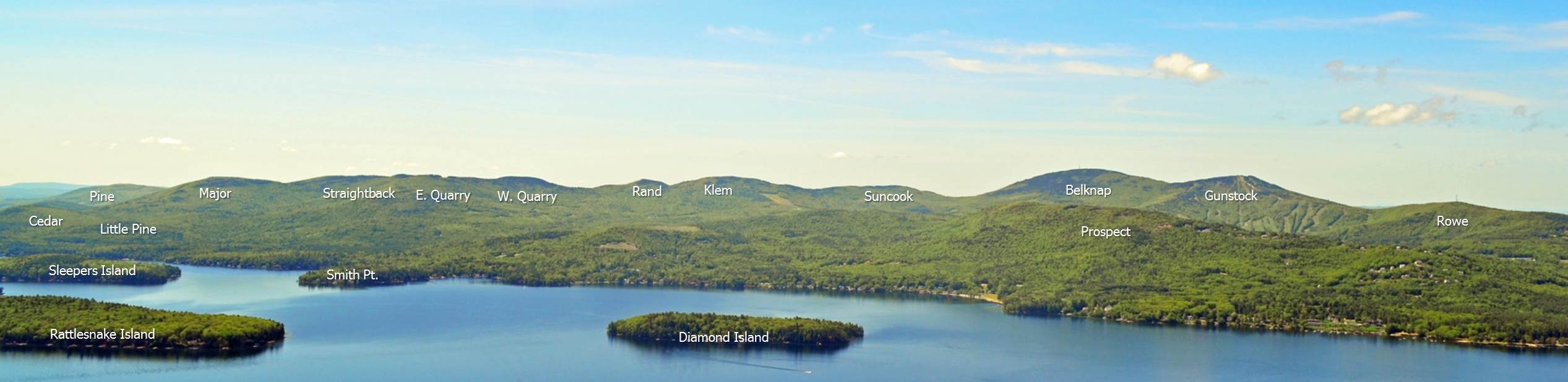
__________________
|

|

|
| The Following 5 Users Say Thank You to mcdude For This Useful Post: | ||
bclaker (11-19-2015), gillygirl (11-17-2014), Just Sold (11-18-2014), rgilfert (11-17-2014), Slickcraft (11-17-2014) | ||
|
11-17-2014, 11:27 AM
|
#2 |
|
Senior Member
Join Date: Mar 2008
Location: Welch Island and West Alton
Posts: 3,263
Thanks: 1,203
Thanked 2,035 Times in 934 Posts
|
Thanks dude, BRATTS is a great group of dedicated folk. The new map was a collaborative effort, led by BRATTS, involving several groups and lots of volunteers. Of course the Dave Robert's map is primarily the work of that one special person.
|
|
|
|
|
11-17-2014, 06:28 PM
|
#3 |
|
Senior Member

Join Date: Mar 2012
Location: Bedford, NH / Rattlesnake Island
Posts: 299
Thanks: 152
Thanked 227 Times in 57 Posts
|
Awesome map & info!!! Thank you so much for your post!! Our summer home is located directly under the "d" in "Rattlesnake Island" (in your post) and I am currently trying to put together a similar map of the mountains in our primary view (ie looking north and west towards the Ossipee Mts, Red Hill, Sandwich Mts and White Mts. My approach has been extremely time consuming! I purchased two 30' x 60' USGS Topographic maps ("Mt. Washington" & "Lake Winnipesaukee" maps) and using a protractor against known benchmark Mts (like Bald Knob, Mt Shaw, Red Hill, etc) try to figure out the other peaks (Mt Washington, Chocorua, etc). I would really like to be able to speak intelligently (and accurately) when a visitor visiting us on the island points at a distant peak and asks me what it is. I always have a very confident response ... But really don't have much of a clue if I'm right or not. I honestly think that the peak that I always say is Mt Washington is actually way too far to the west of where the mountain actually is. Can you (or anyone) provide input as to a better way of accomplishing this?
|
|
|
|
|
11-17-2014, 09:25 PM
|
#4 |
|
Senior Member
Join Date: Apr 2004
Location: NH
Posts: 2,689
Thanks: 33
Thanked 439 Times in 249 Posts
|
Since the Belknaps are my favorite summer exercise, I really appreciate the work these people do. I can't count the number of times I've seen them working the trails. They really show what volunteers can do.
|
|
|
|
|
11-18-2014, 06:38 AM
|
#5 |
|
Senior Member
Join Date: Mar 2008
Location: Welch Island and West Alton
Posts: 3,263
Thanks: 1,203
Thanked 2,035 Times in 934 Posts
|
The BRCC had a direct role in the Mt Major campaign and supported BRATTS in the development of the new map.
http://belknaprange.org/ |
|
|
|
| Sponsored Links |
|
|
|
11-18-2014, 07:58 AM
|
#6 |
|
Senior Member
Join Date: Jul 2012
Posts: 60
Thanks: 145
Thanked 17 Times in 16 Posts
|
Thanks for this post. I've saved it to my favorites and hope to do more hiking in the Belknaps next summer. Are there any local hiking groups that forum readers would recommend getting involved with?
|
|
|
|
|
11-18-2014, 03:20 PM
|
#7 |
|
Senior Member
Join Date: Apr 2008
Location: Moultonborough
Posts: 741
Thanks: 4
Thanked 257 Times in 169 Posts
|
"Are there any local hiking groups that forum readers would recommend getting involved with? "
BG, Google on "Over The Hill Hikers." The group started in Sandwich some years back, but now draw from around the Lakes, and even one form MA. There are different groups, according to hiking ability and hike preferences. |
|
|
|
| The Following User Says Thank You to DickR For This Useful Post: | ||
Bernie Girl (11-19-2014) | ||
|
11-19-2014, 06:59 AM
|
#8 |
|
Senior Member
Join Date: Mar 2012
Location: Bedford, NH / Rattlesnake Island
Posts: 299
Thanks: 152
Thanked 227 Times in 57 Posts
|
Last summer My wife and I joined the "Lakes Region Conservation Trust" that, among other things, hosts many guided excursions that are extremely interesting and informative. Check out the following" http://lrct.org/
|
|
|
|
| The Following User Says Thank You to rgilfert For This Useful Post: | ||
Bernie Girl (11-19-2014) | ||
|
11-19-2014, 07:22 AM
|
#9 | |
|
Senior Member
Join Date: Jul 2002
Location: Rock Haven Lake - West Newfield, ME
Posts: 5,366
Thanks: 374
Thanked 1,053 Times in 493 Posts
|
Quote:
__________________
|
|
|
|
|
| The Following User Says Thank You to mcdude For This Useful Post: | ||
rgilfert (11-19-2014) | ||
|
12-20-2014, 12:07 PM
|
#10 | |
|
Senior Member
Join Date: Mar 2012
Location: Bedford, NH / Rattlesnake Island
Posts: 299
Thanks: 152
Thanked 227 Times in 57 Posts
|
Quote:
|
|
|
|
|
| The Following User Says Thank You to rgilfert For This Useful Post: | ||
mcdude (12-20-2014) | ||
|
12-20-2014, 03:10 PM
|
#11 |
|
Senior Member
Join Date: Jul 2002
Location: Rock Haven Lake - West Newfield, ME
Posts: 5,366
Thanks: 374
Thanked 1,053 Times in 493 Posts
|
nice job rgilfert! I did something similar. I bought two topo maps on-line and brought them to a framer who cut them and pieced them together to cover the area around Hills Pond. Like you, I used acrylic and a light weight frame so that it could be easily taken down off the wall for quick reference. The old topo maps name all the peaks, their elevation and some hiking trails.
Here's a link to the UNH collection of on-line topo maps by town with most towns having a 1909, 1929 and 1957 version of the way things were back then http://docs.unh.edu/towns/NewHampshireTownList.htm
__________________
|
|
|
|
| The Following User Says Thank You to mcdude For This Useful Post: | ||
rgilfert (12-20-2014) | ||
|
12-20-2014, 04:30 PM
|
#12 |
|
Senior Member
Join Date: Mar 2012
Location: Bedford, NH / Rattlesnake Island
Posts: 299
Thanks: 152
Thanked 227 Times in 57 Posts
|
McDude, that's exactly the same process that I followed (I assume that you had your pieced together maps "dry mounted") except that my frame wasn't very light because I made it myself out of oak. Given that each map covers a 30' x 60' area ..... the resultant map consolidation is huge but will be perfect for my purposes.
I bought a cheap iPad application (Spyglass) that superimposes a compass rose in the camera viewing window. Given the fact that from our cottage Mt Shaw is dead north of us I will be able to sight the compass in on the peak that I want to identify and determine the exact number of degrees that it is east or west of true north. Then going to my map with a protractor I'll be able to plot an accurate line (using dry erase markers) and see which peak it passes over. Ultimately I want to take a panoramic photograph of our view and then use our photo editing software to annotate all of the peaks with text. The bummer is ..... I can't start the next step of this project until ice-out!! I realize that this may be a tad "over the top" .... but I'm retired and having a ball doing it. I just wish that I didn't have to wait until April toi make more progress! Last edited by rgilfert; 12-20-2014 at 04:46 PM. Reason: Add photo |
|
|
|
|
01-26-2015, 09:10 AM
|
#13 |
|
Junior Member
Join Date: Feb 2014
Posts: 1
Thanks: 0
Thanked 2 Times in 1 Post
|
Actually, the latest trail map and website: http://belknaprangetrails.org were something I developed. I had a lot of help from various BRATTS, particularly Hal Graham who verified accuracy and trail names. Some BRATTS members, especially Steve Zimmer, helped by re-GPS'ing many of the trails and confirming various details. You can also see from the website that it benefitted immensely from the collaboration of Dave Roberts who provided some descriptions of Belknap Range highlights and some photos. Both the new map and his map are downloadable from the site. The maps are also available for a nominal charge at some of the Lakes Region's public libraries.
I took the aerial photos of the range that are published on the website while in a private plane owned and piloted by Al Rollins. Thanks again, Al. There are still some hiking trails that still need a written description. These are noted on the various web pages. I can always use new photos of the natural and historical features in the Belknap Range. If you have new details or corrections, you can write me at wbosworth@metrocast.net. |
|
|
|
| The Following 2 Users Say Thank You to Weldini For This Useful Post: | ||
mcdude (01-26-2015), Slickcraft (01-26-2015) | ||
|
11-19-2015, 01:38 PM
|
#14 |
|
Senior Member
Join Date: Jul 2002
Location: Rock Haven Lake - West Newfield, ME
Posts: 5,366
Thanks: 374
Thanked 1,053 Times in 493 Posts
|
nice article in the Daily sun today about hiking in the Belknaps that pays homage to Dave Roberts.
__________________
|
|
|
|
| The Following User Says Thank You to mcdude For This Useful Post: | ||
Slickcraft (11-19-2015) | ||
|
11-19-2015, 06:07 PM
|
#15 | |
|
Senior Member
Join Date: Mar 2008
Location: Welch Island and West Alton
Posts: 3,263
Thanks: 1,203
Thanked 2,035 Times in 934 Posts
|
Quote:
http://www.laconiadailysun.com/speci...o-the-belknaps |
|
|
|
|
|
| Bookmarks |
|
|


 Linear Mode

