

|
|
|
|
|
|||||||
| Home | Forums | Gallery | Webcams | Blogs | YouTube Channel | Classifieds | Calendar | Register | FAQ | Donate | Members List | Today's Posts | Search |
 |
|
|
Thread Tools | Display Modes |
 07-14-2007, 06:26 PM
|
#1 |
|
Senior Member

Join Date: Apr 2004
Location: Topsfield
Posts: 56
Thanks: 4
Thanked 11 Times in 3 Posts
|
I was wondering if anyone had tried Bizer's new map for Garmin GPS? I recently bought it and am thrilled with finally being able to see shoreline detail and all the bouy's and rocks. It really works great. I'm a big fan of Garmin's hardware, however their lack of support on providing a Lake Winni chart has been frustrating. Thanks to Bizer, its no longer an issue.
Last edited by cowislander; 07-15-2007 at 12:39 PM. |

|

|
|
07-14-2007, 08:57 PM
|
#2 |
|
Senior Member
Join Date: Aug 2006
Posts: 284
Thanks: 40
Thanked 33 Times in 30 Posts
|
I'm using the Garmin version of Bizer's chart with a 276c (same unit pictured with screen shots on the Bizer website) and find it great. Of course it doesn't yet include everything on the C-Map version, as many of the preferred routes are not yet noted. But with all the island names, markers, and rocks it covers most of what I need, so I'm very pleased. (The paper chart is also always at hand.)
My primary driver for this choice was the ability to have a dual-purpose unit that can also be used in the car or motorcycle allowing me to save some cash overall. If I was only intending to use it for boating I would have gone the Standard Horizon/C-Map chip route. NHskier |
|
|
|
|
07-14-2007, 09:00 PM
|
#3 |
|
Senior Member
Join Date: Apr 2004
Location: Topsfield
Posts: 56
Thanks: 4
Thanked 11 Times in 3 Posts
|
Thats why I went with the Garmin several years ago, I use mine for hiking, ocean nav, in the car. Glad to have it be loaded with the Bizer map now. The Bizer site does say they plan to continue to improve the map....adding depth contours, etc...
|
|
|
|
|
08-15-2007, 06:14 AM
|
#4 |
|
Senior Member

Join Date: May 2005
Location: Isola Gatto Nero
Posts: 696
Thanks: 162
Thanked 263 Times in 81 Posts
|
Bizer or others that may have a clue,
I know nothing about GPS other than using NeverLost when I travel, so please forgive my ignorance on the subject. I am looking for a transportable GPS primarily for my motorcycle and the car, but it would be nice to use on the lake occasionally as well. The Zumo 450 is sold as a bike GPS system that also works in the car, but says nothing of marine use. Is there any reason why it would not work with your Lake Winni data? I've been navigating the lake OK for about 14 years without one so I'm thinking I don't need a lot of features. I would primarily use it to add a level of comfort if I occasionally needed to get from say from Wolfeborough or Gilford back to Moultonborough at night. Here is a link to the unit at Amazon. http://www.amazon.com/Garmin-Zumo-45...7175775&sr=8-1 Thanks
__________________
La vita è buona su Isola Gatto Nero |
|
|
|
|
08-15-2007, 04:40 PM
|
#5 |
|
Senior Member
Join Date: Jan 2003
Location: Alton Bay
Posts: 5,547
Blog Entries: 2
Thanks: 2,398
Thanked 1,918 Times in 1,061 Posts
|
The unit according to its specs is waterproof to IPX7 standards. It seems that is a good thing.
If you go to garmin.com and go to that unit under motorcyle units, select that unit and then select the Manual in the upper right hand corner of the screen, you can download in adobe reader the manual. Under the "preface" it does have one caveat that says the sensitive electronics can be damaged if exposed to excessive shock and vibration outside normal motorcycle use. I was also looking at a garmin that I can in my vehicle as well as my boat, and was concerned about that statement. I have a 19 ft bowrider and we can get tossed around a little on occasion, and am concerned about the unit getting damaged from wave pounding, or the vibration of an outboard. I have decided to wait a while and see how others make out.
__________________
I Live Here... I am always UPTHESAUKEE !!!! |

|
|
| Sponsored Links |
|
|
|
08-15-2007, 05:04 PM
|
#6 |
|
Senior Member

Join Date: Apr 2007
Location: Chicago IL and Moultonborough
Posts: 165
Thanks: 3
Thanked 5 Times in 5 Posts
|
Anyone know which Garmin I should get for use on the lake only and plug the Bizer map in? I went to the website and got confused - it looks like I need the 5x5 series?
|
|
|
|
|
08-15-2007, 05:11 PM
|
#7 |
|
Senior Member

Join Date: Aug 2007
Location: South Down Shores
Posts: 1,937
Thanks: 532
Thanked 568 Times in 334 Posts
|
Interesting. I have a question for the Garmin users... What is the difference between the various Garmin marine models (other than the price)? I'm trying to differentiate between them by shopping online, and even the comparator on Garmins own site doesn't point out any relevant differences between a 430s and a 535s (for example).
If someone could point out the reason for spending the extra few hundred bucks (or not), I'd be grateful. |
|
|
|
|
08-15-2007, 09:11 PM
|
#8 |
|
Senior Member
Join Date: Aug 2006
Posts: 284
Thanks: 40
Thanked 33 Times in 30 Posts
|
I would recommend starting with the list from Bizer's site of Garmin units that are known to work OK with the map, just to be sure:
"05-Aug-07 - If Bizer's Garmin file does not operate on your Garmin GPS, Bizer will refund you money. So far, no problem has been reported on any Garmin less than five years old. Users have reported success on the folowing Garmin GPS units: 60C, 76S, 76CS, 76CSx, 176, 176C, 178C, 276C, 296, 376C, 378, C530, Etrex Legend, Quest, Street Pilot, V." For at least some Garmin units the only real difference is whether maps are included/built-in to the unit or not. These show up as series of like-appearance units. There's usually one with a lakes map (no real Winni details) and one for offshore. In other cases it's newer features like XM satellite radio compatiblity for weather info. That's the case for the 276c/376c/378/478 series. The compare feature on Garmin's site provides a side-by-side comparison of units. For example, comparing the 430s & 535s shows the 535s has a bigger screen with higer resolution and is overall larger in size. Looks like all other features are identical. NHskier |
|
|
|
|
08-16-2007, 09:00 AM
|
#9 |
|
Senior Member
Join Date: Apr 2007
Location: Chicago IL and Moultonborough
Posts: 165
Thanks: 3
Thanked 5 Times in 5 Posts
|
Thank you, NHskier!
|
|
|
|
|
08-17-2007, 05:45 AM
|
#10 |
|
Junior Member
Join Date: Mar 2007
Posts: 18
Thanks: 0
Thanked 0 Times in 0 Posts
|
DO you know if the software will work on a Garmin 496?
|
|
|
|
|
08-17-2007, 08:39 PM
|
#11 |
|
Senior Member
Join Date: Aug 2006
Posts: 284
Thanks: 40
Thanked 33 Times in 30 Posts
|
Bizer provides a test file you can download from the website:
http://www.bizer.com/garmin to see whether it will work on your unit. You need to be able to attach your unit to your computer to do the transfer. NHskier |
|
|
|
|
08-18-2007, 08:48 PM
|
#12 | |
|
Senior Member

Join Date: Jul 2002
Location: Massachusetts
Posts: 332
Thanks: 0
Thanked 242 Times in 81 Posts
|
Quote:
As previously stated, if it doesn't work or if it just isn't your cup of tea, Bizer will refund your $$$ (So far, nobody has asked for their $$$ back). |
|
|
|
|
|
08-18-2007, 10:34 PM
|
#13 | |
|
Senior Member
Join Date: Feb 2006
Location: I'm right here!
Posts: 1,153
Thanks: 9
Thanked 102 Times in 37 Posts
|
Is it possible for someone to show me what you are talking about? (maybe a photo?)
I don't have a GPS on the Winni boat, but I would consider one. Cowislander wrote: Quote:
Please explain if you (everyone) would. Thanx |
|
|
|
|
|
08-19-2007, 12:46 PM
|
#14 | |
|
Senior Member
Join Date: Apr 2004
Posts: 1,325
Thanks: 5
Thanked 0 Times in 0 Posts
|
Quote:
Bizers Garmin version:
 Bizer's normal version: 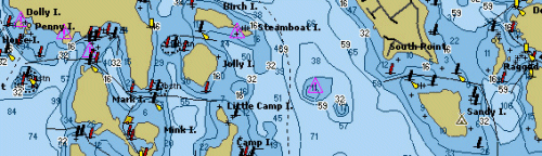
__________________
[Assume funny, clever sig is here. Laugh and reflect...   ] ]
|
|
|
|
|
|
08-19-2007, 09:09 PM
|
#15 |
|
Senior Member
Join Date: Aug 2006
Posts: 284
Thanks: 40
Thanked 33 Times in 30 Posts
|
Airwaves,
You can compare a paper Bizer chart with the photos shown on the website page I referenced in an earlier post. You won't see the blue shoals areas or the water depth contours. You will see the islands, rocks, and markers. The C-Map version of the Bizer chart, which can be used on some Standard Horizon units (and others?) is equivalent to the paper chart. NHskier |
|
|
|
|
08-21-2007, 12:32 PM
|
#16 |
|
Senior Member
Join Date: Feb 2006
Location: I'm right here!
Posts: 1,153
Thanks: 9
Thanked 102 Times in 37 Posts
|
So at this point in development the C-Map version in a Standard Horizon unit is more detailed than the Garmin unit's version?
I guess that is what my question boils down to, which unit GPS would produce the best result on Lake Winnipesaukee. As far as paper charts go I was a fan of the single page chart of the lake I find the half on the front and half on the back that Bizer and Duncan now produce a pain so that's why I'm considering adding a GPS. |
|
|
|
|
08-21-2007, 07:52 PM
|
#17 |
|
Senior Member
Join Date: Aug 2006
Posts: 284
Thanks: 40
Thanked 33 Times in 30 Posts
|
The C-Map version has been available for some time and is complete. The Garmin version is new and still in development. So yes, at this point the C-Map version is the best.
While many shops around the lake probably carry the Standard Horizon unit and C-Map chip, I know that Thurston's has the unit on display on the counter in their showroom. Hopefully Bizer has seen enough interest in the Garmin version to continue development and add in the remainder of features in the not-too-distant future. NHskier |
|
|
|
|
08-22-2007, 05:08 PM
|
#18 |
|
Junior Member
Join Date: Mar 2007
Posts: 18
Thanks: 0
Thanked 0 Times in 0 Posts
|
The test download worked on the 496, so I sent my $ for the full file. I will let you know my success with the whole thing when I get it.
|
|
|
|
|
08-23-2007, 04:58 PM
|
#19 | |
|
Senior Member
Join Date: May 2005
Location: Isola Gatto Nero
Posts: 696
Thanks: 162
Thanked 263 Times in 81 Posts
|
Quote:
__________________
La vita è buona su Isola Gatto Nero |
|
|
|
|
|
08-24-2007, 06:07 AM
|
#20 |
|
Junior Member
Join Date: Mar 2007
Posts: 18
Thanks: 0
Thanked 0 Times in 0 Posts
|
Got the software emailed from Bizer and it downloaded perfectly to the 496. Understand it is a prototyple at this point, but it is much better than the "old" C-Chip I had in a 2001 boat. It identifies buoy's and suggested travel routes but lacks the glitz of more developed software. I dont see any reason Bizer won't get there for 2008.
|
|
|
|
|
08-24-2007, 11:59 AM
|
#21 |
|
Senior Member
Join Date: Jun 2007
Posts: 298
Thanks: 14
Thanked 147 Times in 62 Posts
|
Good to hear it works on the Nuvi and the E-trex since I have both. This would be more valuable for me if it had recommended routes around certain markers since a few areas are a bit tricky as you direction changes from N/S to E/W.
|
|
|
|
|
03-17-2008, 12:53 PM
|
#22 |
|
Senior Member
Join Date: May 2005
Location: Isola Gatto Nero
Posts: 696
Thanks: 162
Thanked 263 Times in 81 Posts
|
According to the Bizer web site http://www.bizer.com/garmin/ they have made some improvements. Curious to see if anyone has tried them out (on a sled) since the latest revision.
__________________
La vita è buona su Isola Gatto Nero |
|
|
|
|
06-02-2008, 11:56 AM
|
#23 |
|
Senior Member

Join Date: Feb 2008
Location: Gilford
Posts: 246
Thanks: 145
Thanked 58 Times in 42 Posts
|
I've been trying to load the bizer test file (3islands) onto my Nuvi 200w, but no matter how I try it it does not seem to work. Everything appears to be going smoothly onscreen, but then when I disconnect, go to settings > map, then click "map info" on the bottom of the screen, only my onboard road map is listed as a selectable option. Any suggestions?

|
|
|
|
|
06-02-2008, 04:37 PM
|
#24 |
|
Deceased Member

Join Date: Jul 2002
Posts: 1,701
Thanks: 115
Thanked 25 Times in 13 Posts
|
Overlake97 try this. If you have a NuVi or StreetPilot, please read garmnuvi.doc. http://www.bizer.com/garmin/garmnuvi.doc
Let me know how it works I just got one of these for a 35 year anniversary gift from work. |
|
|
|
|
06-03-2008, 09:23 AM
|
#25 |
|
Senior Member
Join Date: Feb 2008
Location: Gilford
Posts: 246
Thanks: 145
Thanked 58 Times in 42 Posts
|
I had already read the garmnuvi.doc, and followed the procedure, but that seems to describe what to do with the official purchased file, not the "test" 3islands file. I did everything the garmnuvi.doc suggested, except for changing the name (which seemed to relate to the full operational file). There is also a 'read me' file which downloads along with the zipped 3islands test file. That describes a slightly different procedure, which also did not work.
The person answering the phone at BIZER said he'd never heard of it not working on any particular Garmin unit, so I'm still hopeful. Maybe I'll call him again.
|
|
|
|
|
06-03-2008, 09:59 AM
|
#26 | |
|
Senior Member
Join Date: Jul 2002
Location: Massachusetts
Posts: 332
Thanks: 0
Thanked 242 Times in 81 Posts
|
Quote:
|
|
|
|
|
|
06-03-2008, 11:04 AM
|
#27 |
|
Senior Member
Join Date: Feb 2008
Location: Gilford
Posts: 246
Thanks: 145
Thanked 58 Times in 42 Posts
|
Thanks BIZER! I changed the name from 3islands to GMAPSUPP.IMG as instructed on the garmnuvi.doc page (and as you noted above), then dragged that file into the Garmin (K) folder showing on "my computer" (Dell laptop). Then I opened the Garmin (K) folder/directory and further dragged the GMAPSUPP.IMG into the Garmin folder inside.
That last step was essential, as just dragging the file into the main Gamin (K) folder/directory (where it showed up besides "Garmin" and "JPEG" folders on my system) did not do the trick. Meaning, opening settings > maps > map info [at screen bottom] on the nuvi did not show that the map had been downloaded. After doing the second drag, the test map appeared there just as described in the garmnuvi.doc page. I seleced it, de-selected the other (main) map, went back to the screen, and there it was! Long, Cow and Bear islands - with buoys showing. So, the test worked and my check for winni-g2 is in the mail! |
|
|
|
|
06-05-2008, 09:52 PM
|
#28 |
|
Senior Member
Join Date: Jan 2003
Location: Alton Bay
Posts: 5,547
Blog Entries: 2
Thanks: 2,398
Thanked 1,918 Times in 1,061 Posts
|
Test worked fine, once I figured out how to zoom in. No difference with the Streetpilot as far as color goes...buoys were the same color...no matter, it's not my primary navigation tool anyway as I will always have my Bizer chart handy as well. Oh yeah, my check is in the mail as well.
thanks bizer.
__________________
I Live Here... I am always UPTHESAUKEE !!!! |
|
|
|
|
06-20-2008, 03:01 PM
|
#29 |
|
Senior Member
Join Date: Jan 2003
Location: Alton Bay
Posts: 5,547
Blog Entries: 2
Thanks: 2,398
Thanked 1,918 Times in 1,061 Posts
|
Here is a copy of the email I sent to Bizer as feedback for the V2 map I got recently.
Hello Stewart: Thanks for your prompt service on the download for the Garmin V2. It uploaded like a dream. A few comments Unit: Garmin Steetpilot c550. Usually acquires signals very quickly and is easy to change from Lake map to Street map. If I had a blue tooth phone, it would be even better, but that will be coming down the road. Easy controls. Software: As you have already noted, the buoys are not colored due to the unit being primarily an auto unit. If you zoom in enough, you can see the RW or BW or FLxx, giving you ample opportunity to visually locate the markers or slow down / stop until you do. We have only gone out on the eastern end of the lake, and only for a few short trips. Last evening, just after supper, we went out for a ride, and came out of Alton Bay from Parkers, around Clay Point and down by Kenniston Island. In that area, there are a few rocks that are not marked by the Marine Patrol, but you have shown them by RCK...thank you. In short, the software currently is operating as I thought it would. Particularly nice are the "safe routes" , ie: Alton - Wolfeboro. Also, the lines that delineate shallower water parallel to shore. When zoomed in enough, this feature does not seem to "clutter" the map, in my opinion. Using the unit with the software. 1. There are no breadcrumbs like on other GPS units. 2. I selected my dock as a favorite before leaving. Out in the middle of Rattlesnake, Treasure, and Ship Islands, heading southwesterly, I selected go to: Dock, and the unit advised me to drive south to route 11, then turn left! Where is that amphibian car when you need it. 3. Unit does not do well in direct sunlight, usually requiring me to take off my sunglasses. Unfortunately, I do not have a place that is shaded on my "dash". 4. The Garmin windshield mount does work nicely on Gelcoat! 5. I have been using it just on battery power, and find that in that mode, doing a lot of changes such as zooming in and out seems to use a lot of additional battery power, as does having to keep it up at 100% daytime bright. Might have to add a 12V outlet. Bottom line: as you so aptly warn, I do not use the unit and software as my primary means of navigation. I always have my Bizer laminated 11x17 chart next to my seat for easy reference, and slow down to find my marks as necessary. The unit will be a great assist, especially at night to help find a few of those pesky markers, or spot Moose Is or Ship Is., or when in unfamiliar territory. With a marine unit, I can only imagine how wonderful it can be. With an auto unit, understand your limitations and use it as an assistance tool, and it will pay for itself in a season or two. Thanks Stewart. Hope this helps others with their choice of units, features, and drawbacks. I just could not swing getting up into the $600 range for a Marine model, and wanted to be able to use it on land as well. My wife can make use of it at least once a week in the summer, and so having one that can do both weighed heavily on my decision. Safe boating to all. Dave
__________________
I Live Here... I am always UPTHESAUKEE !!!! |
|
|
|
|
06-27-2008, 05:16 PM
|
#30 | |
|
Deceased Member

Join Date: Nov 2002
Location: 1/2 way between Boston & Providence
Posts: 573
Blog Entries: 3
Thanks: 32
Thanked 55 Times in 22 Posts
|
Quote:
Maybe you have POLARIZED lenses in your sunglasses. If you do, your problem is not a dim Garmin display but light cancellation due to polarization. The Garmin and many other displays are Liquid Crystal Displays (LCDs). All LCD light is polarized which, in the right orientation, can be blocked by polarized lenses. Polarized sunglasses usually block horizontally polarized light. A test for this is to rotate either your sunglasses or the LCD through at least 90 degrees while you observe the LCD through the glasses. If the "brightness" or ability to read the display changes considerably during the rotation you know that it is an issue of polarization rather than the brightness of the display. This holds true for all polarized sunglasses and any LCD display - and LCDs are everywhere. Again, it's just a thought about your Garmin - it may be that the display is not bright enough for sunny places - that happens too. 
__________________
 Amateur HAM Radio What is it? You'll be surprised. When all else fails Ham Radio still works. Shriners Hospitals providing specialized care for children regardless of ability to pay. Find out more or refer a patient. |
|
|
|
|
|
07-02-2008, 08:16 AM
|
#31 |
|
Member
Join Date: Jul 2004
Location: Danvers,MA and 1 wk/yr Wolfeboro
Posts: 47
Thanks: 0
Thanked 21 Times in 7 Posts
|
I will be making my 18th annual trip to Wolfeboro on August 1st and rent a boat for the week. I have both a Nuvi 350 and a 360 and wanted to use one for the boat. I have read the thread traffic about loading the Winni map onto the units. One question-I bought the Garmins "as-is" off the shelf. Do I need to purchase anything else in order to be able to do the download or do I just plug the USB cable in the computer and start the process? My thanks in advance for the help and advice-cant wait to get to the lake-it is my one week of heaven all year.................
|
|
|
|
|
07-02-2008, 09:21 AM
|
#32 | |
|
Senior Member
Join Date: May 2005
Posts: 157
Thanks: 0
Thanked 2 Times in 2 Posts
|
Quote:
|
|
|
|
|
|
07-02-2008, 10:15 AM
|
#33 |
|
Senior Member
Join Date: Feb 2008
Location: Gilford
Posts: 246
Thanks: 145
Thanked 58 Times in 42 Posts
|
Coley,
My off-the-shelf garmin nuvi 200w did not require anything extra. Just follow the directions, making sure to remame the file (see my earlier posts), and it should work just fine. I can see everything (depths included), in full color, with the new version of the map for garmin.
|
|
|
|
|
07-12-2008, 06:34 PM
|
#34 |
|
Member
Join Date: Jul 2004
Location: Danvers,MA and 1 wk/yr Wolfeboro
Posts: 47
Thanks: 0
Thanked 21 Times in 7 Posts
|
I have a garmin nuvi 350. I followed the instructions everyone has given-can see the file in the 350--but when I do the part to see the map on the garmin, it isnt showing--I have deselected the other map and have checked only the file of winniepsaukee in the settings--any ideas to help out there??Thanks...........
|
|
|
|
|
07-12-2008, 10:30 PM
|
#35 |
|
Senior Member
Join Date: Jan 2003
Location: Alton Bay
Posts: 5,547
Blog Entries: 2
Thanks: 2,398
Thanked 1,918 Times in 1,061 Posts
|
Don't know where you are located at, but if not in the lakes region, zoom out until you can find the lake, drag the lake to the center and then zoom in and re-center until you can see the test section of the lake. Took me a bit to get it done, and thanks to Overlake97 and Bizer's instructions, I am still the happy owner of a Garmin Streetpilot with a Bizer Winni V2 map.
Also, Skipper of the Sea Que, the display is not particulary bright on it's own in bright sunlight, and putting on sunglasses does make it a little darker. The specs on this model don't brag about great visibility in bright sunlight like other units do. As I said before, it is workable, and I still love it.
__________________
I Live Here... I am always UPTHESAUKEE !!!! |
|
|
|
|
07-13-2008, 10:02 AM
|
#36 |
|
Member
Join Date: Jul 2004
Location: Danvers,MA and 1 wk/yr Wolfeboro
Posts: 47
Thanks: 0
Thanked 21 Times in 7 Posts
|
Thanks for the info on the test file-got it to work and now I will send my check off to Bizer---thanks for the assistance!
|
|
|
|
|
07-13-2008, 12:57 PM
|
#37 |
|
Member
Join Date: Jul 2004
Location: Danvers,MA and 1 wk/yr Wolfeboro
Posts: 47
Thanks: 0
Thanked 21 Times in 7 Posts
|
Once the final maps are loaded. when you put the Garmin on the boat, does it "act" like it does when it is in the car-does it show you where yoiu are and monitor progress?? Sound like a stupid question to be asking but I just dont have any experience with this on a boat-thanks
|
|
|
|
|
07-16-2008, 11:14 PM
|
#38 | |
|
Senior Member
Join Date: Apr 2008
Location: Moultonborough & Southern NH
Posts: 133
Thanks: 6
Thanked 37 Times in 18 Posts
|
Quote:
|
|
|
|
|
|
07-17-2008, 06:48 AM
|
#39 |
|
Senior Member

Join Date: Oct 2007
Location: Bear Island/Fort Myers, Fla
Posts: 229
Blog Entries: 1
Thanks: 1
Thanked 59 Times in 41 Posts
|
I have a 276c which I move between 2 boats and the car. This line of models also has a fish finder capability when connected to a GSD21 sounder. In my fishing boat I split screen the lake chart and the finder. This is done with only a push of a button. Switching from marine to auto is also only a push of a button. This unit will run about 6 hours on it's battery on a full charge or you can install a power cord in each vehicle. Garmin also makes brackets to fit the unit for boats, cars and motor cycles.
|
|
|
|
|
07-17-2008, 08:10 AM
|
#40 | |
|
Senior Member
Join Date: May 2005
Location: Isola Gatto Nero
Posts: 696
Thanks: 162
Thanked 263 Times in 81 Posts
|
Quote:
__________________
La vita è buona su Isola Gatto Nero |
|
|
|
|
|
07-17-2008, 01:37 PM
|
#41 | ||
|
Senior Member
Join Date: Jul 2002
Location: Massachusetts
Posts: 332
Thanks: 0
Thanked 242 Times in 81 Posts
|
Quote:
Quote:
|
||
|
|
|
|
07-17-2008, 07:05 PM
|
#42 | |
|
Deceased Member

Join Date: Jul 2006
Location: Gilford, NH
Posts: 2,311
Thanks: 1,070
Thanked 2,053 Times in 496 Posts
|
Quote:
I will tell you my 200w does work on the lake without the chip, to show all islands. (No markers, suggested routes, depths etc.) But combined with the Bizer chart.. it did make it easier to go to some parts of the lake we haven't been to. ("She who must be obeyed", who mostly pilots the boat, does want me to get the chip and make it work so she can be free of me saying.. ' the chart says!".) It still does look strange having the "car" driving on water. 
__________________
"Before you criticize someone, walk a mile in his shoes. That way, if he gets angry he'll be a mile away and barefoot!" unknown |
|
|
|
|
|
07-18-2008, 06:26 AM
|
#43 |
|
Member
Join Date: Jul 2004
Location: Danvers,MA and 1 wk/yr Wolfeboro
Posts: 47
Thanks: 0
Thanked 21 Times in 7 Posts
|
Gatto Nero:
I will have to double check marker colors but I dont think they showed up in the test file. I ordered the regular file and expect it in a few days. Stupid question again: does the boat show up as a car and does it follow on the map as you go? |
|
|
|
|
07-19-2008, 10:03 AM
|
#44 |
|
Junior Member
Join Date: Jul 2008
Posts: 1
Thanks: 0
Thanked 0 Times in 0 Posts
|
I just bought the new Bizer card for my Garmin GPS276C and I love it!
|
|
|
|
|
07-22-2008, 11:20 AM
|
#45 |
|
Member
Join Date: Jan 2006
Posts: 27
Thanks: 1
Thanked 0 Times in 0 Posts
|
I have yet to see this in stores, but this model may be just the unit that I am looking for. It is billed as a crossover device, supporting on and off road navigation, and waterproof, too.
I have been looking at buying a Garmin along with the Bizer map, but I have held off since I haven't found a model that I believe will provide the "breadcrumbs" feature that I am looking for, other than a marine model. At first glance, the Nuvi 500 may appear to have this type of feature. Here's the link to the Garmin site that gives some more details: https://buy.garmin.com/shop/shop.do?...4&locale=en_US Is anyone familiar with any other similar device that offers the same features? longisland60 |
|
|
|
|
07-22-2008, 04:52 PM
|
#46 |
|
Senior Member
Join Date: Mar 2008
Location: Bear Island/Merrimack
Posts: 710
Thanks: 56
Thanked 170 Times in 104 Posts
|
I really wanted to go with the Bizer chart on a Nuvi but it didn't sound like the lake map would definitiely work. I went with the Lowrance XOG which was the only car gps that would also take a lake map. My unit came with a Navionics lake card and it works great on Winni. Its hard to read in daylight but I think most lcd screens are. At night its a little bright even at its dimmest setting. For $250 with lake card it was worth the money. Had the Garmin 500 been available at the time I may have gone that route. Looks very interesting and I wonder if it will have the same Bizer compatibility issues the other Nuvis have. I also like that it has an 8 hour (replaceable) battery life where my XOG only runs for up to 2 hours.
Rick |
|
|
|
|
07-22-2008, 11:05 PM
|
#47 |
|
Senior Member
Join Date: Aug 2007
Posts: 86
Thanks: 21
Thanked 15 Times in 9 Posts
|
rick35 where did you purchase the Lowrance XOG with the Winni card... i like the $250 price
|
|
|
|
|
07-23-2008, 06:46 AM
|
#48 |
|
Senior Member

Join Date: Jul 2005
Location: Berlin, Ma / Gilford
Posts: 1,931
Thanks: 445
Thanked 604 Times in 340 Posts
|
longisland60 --- GREAT find (garmin 500) --
I too will be curious to watch and see if someone tries it with the Bizer chip and posts their experiance!!
__________________
A bad day on the Big Lake (although I've never had one) - Still beats a day at the office!! |
|
|
|
|
07-23-2008, 05:26 PM
|
#49 |
|
Senior Member
Join Date: Mar 2008
Location: Bear Island/Merrimack
Posts: 710
Thanks: 56
Thanked 170 Times in 104 Posts
|
I bought my XOG at TigerGPS and it looks like they have decent prices on other brands and models as well. I never heard of them before then but I was very happy with their service. Shipping was fast and returns were painless. I returned my first XOG because the price changed the price the day it arrived. I could have bought the XOG with Navionics Lakes card for the same price or I could get it without for $220. I was planning on buying the 2008 Navionics Premium card which would have added $150 to the total so I figured I'd try the Lakes card. If I didn't like it I could always use it toward the $50 Navionics rebate on the Premium card. I tried my sons Premium card and it had charting errors. A couple of the markers at the south end of Bear Island were missing. On the other hand I have found that the Lakes chart has all the markers right. I posted a screen shot from the XOG in an earlier thread.
http://www.winnipesaukee.com/forums/...ead.php?t=5819 I think I would have been happier with a Nuvi and the Bizer chart but given the uncertainty about compatibility I decided on the XOG. Since the Nuvi 500takes the lake charts from Garmin as does the 276c I'm willing to bet we'll see success with the Bizer chart. Hopefully someone will validate it and share with the rest of us. Rick |
|
|
|
|
09-05-2008, 02:41 PM
|
#50 |
|
Junior Member
Join Date: Aug 2008
Posts: 1
Thanks: 0
Thanked 0 Times in 0 Posts
|
I recently used the W2 version of the Bizer GPS map this summer and was pleased. I purchased the Nuvi 205W which is primarily a car unit. I traveled the entire lake to assess the accuracy of the depth readings and buoy positions and found the GPS map to be very accurate. Like Bizer had mentioned the car units have a few glitches. I found the buoys are colored but not necessarily correctly compared to the paper chart. Secondly the recommended route line through the bouys is pink which does not provide enough contrast with the blue water. You have to rely on the route line since the color of the buoys is not necessarily correct on the screen.
Despite the glitches I found the unit very helpful while navigating the Lake. We have vacationed on the Lake for many years but have always found navigating in unfamiliar areas, tricky. |
|
|
|
|
09-09-2008, 04:19 PM
|
#51 |
|
Senior Member

Join Date: Nov 2007
Location: Effingham
Posts: 408
Thanks: 37
Thanked 19 Times in 15 Posts
|
Have been using the new Bizer data card on my Garmin 172c and find it excellent. Most everything I've seen on it so far seems accurate and feel it is well worth the $$. Of course you still need the paper chart and a good depth finder.
This is the first year I've put my boat in Winnie and I didn't get into my slip til mid August. Hope for a nice Fall. |
|
|
|
|
11-05-2008, 09:34 AM
|
#52 |
|
Senior Member
Join Date: Jul 2005
Location: Berlin, Ma / Gilford
Posts: 1,931
Thanks: 445
Thanked 604 Times in 340 Posts
|
I am about to commit to a Nuvi one way or the other ........ question I have is has anyone loaded the Bizer chip on a Nuvii 500 or 550 model an provide some feedback ?? Refer back to posts #45 - 46
My dilemna is going with a cheaper Nuvi widescreen or going "multipurpose" (car & boat) with the 500 series HELP !!
__________________
A bad day on the Big Lake (although I've never had one) - Still beats a day at the office!! |
|
|
|
|
11-29-2008, 01:12 AM
|
#53 |
|
Junior Member

Join Date: Apr 2006
Location: Central MA, GIW
Posts: 11
Thanks: 2
Thanked 0 Times in 0 Posts
|
Hi Phantom,
I have been waiting for a cross over GPS unit that is waterproof AND touchscreen. I just picked up the Garmin Nuvi 550. I have copied the Bizer 3islands image file onto the Garmin device and while I can see the labeled islands, I can't see any other artifacts such as the buoys. I'll post my progress as it occurs, but if you figure it out before me please enlighten me. -PIer626 |
|
|
|
|
12-01-2008, 07:39 PM
|
#54 |
|
Junior Member
Join Date: Apr 2006
Location: Central MA, GIW
Posts: 11
Thanks: 2
Thanked 0 Times in 0 Posts
|
I had purchased a Garmin Nuvi 550 with the intention of adding the Bizer map. After testing my device using the 3islands test file from Bizer I'd reported that I could not see the buoys.
I called Garmin and spoke at length to one of their support reps. The 550 model is NOT listed as compatible with their Inland Lakes and Inland Lakes Vision map products. The reason I was given is that the 550 device lacks the topographic detail basemap, therefore it will not show the boating detail map objects. The Nuvi 500 model, which comes preinstalled with the US Topo map will fully support the marine/boating details and is shown as being compatible with the Garmin Inland Lakes (and Inland Lakes Vision) maps. I'll be returning my 550, picking up the 500 model, and looking again at the Bizer test file. -Pier626 |
|
|
|
|
12-01-2008, 11:35 PM
|
#55 |
|
Senior Member
Join Date: Jan 2003
Location: Alton Bay
Posts: 5,547
Blog Entries: 2
Thanks: 2,398
Thanked 1,918 Times in 1,061 Posts
|
Did you zoom in, and I mean a lot. It seems that when I tested it on my Streetpilot 550c, I had to really zoom in past where I could see the islands. Try that before you trade in.
My streetpilot does not have the capability to add the Inland lakes...Only the street maps. Good luck
__________________
I Live Here... I am always UPTHESAUKEE !!!! |
|
|
|
|
12-03-2008, 12:07 AM
|
#56 |
|
Junior Member
Join Date: Apr 2006
Location: Central MA, GIW
Posts: 11
Thanks: 2
Thanked 0 Times in 0 Posts
|
Good idea, but still nothing when the Nuvi 550 is set to boating mode.
Interestingly enough, in Car mode I see the navaids, but they showup as ghost-like circles with an x overlayed. Well, maybe it was a + sign and my head was skewed. So apparently the topographic basemap also has the map legend items as they should appear, but the topo is not on the 550.West Marine accepted my return with no hassle, and I have ordered the Nuvi 500...so now I must wait. I'll keep you posted. -Pier626 |
|
|
|
|
12-06-2008, 10:36 PM
|
#57 |
|
Junior Member
Join Date: Apr 2006
Location: Central MA, GIW
Posts: 11
Thanks: 2
Thanked 0 Times in 0 Posts
|
I manually loaded the Bizer 3islands image file into my new Garmin Nuvi 500 and I am able to see the spar buoys including colors. Whoo hoo!!!
Now I just need the full Bizer garmin formatted mapfile and I'll be good to go!! -PIer626 |
|
|
|
|
12-31-2008, 01:10 PM
|
#58 |
|
Senior Member

Join Date: Feb 2008
Location: Upton, MA/Alton Bay
Posts: 81
Thanks: 20
Thanked 14 Times in 8 Posts
|
Hey everyone,
Thanks for all the good info on here, both on this thread and all the others on this site. Does anyone know if the bizer charts would (or will) work on the new Garmin Oregon? I was thinking of getting one for my motorcycle and car, if i could use it on the boat it would make my buying decision a lot easier. 
|
|
|
|
| The Following User Says Thank You to Piston For This Useful Post: | ||
JacksonB (01-20-2016) | ||
|
01-17-2016, 09:04 PM
|
#59 |
|
Junior Member
Join Date: Jan 2016
Posts: 1
Thanks: 0
Thanked 0 Times in 0 Posts
|
Does anyone have an old SD card they would like to sell with legacy Bizer or Garmin lake Winni maps loaded on it?
|
|
|
|
|
| Bookmarks |
|
|


 Linear Mode

