

|
|
|
|
|
|||||||
| Home | Forums | Gallery | Webcams | Blogs | YouTube Channel | Classifieds | Calendar | Register | FAQ | Donate | Members List | Today's Posts | Search |
 |
|
|
Thread Tools | Display Modes |
|
|
 08-23-2011, 04:11 PM
|
#1 |
|
Senior Member

Join Date: Apr 2004
Location: North Shore, MA
Posts: 1,356
Thanks: 991
Thanked 311 Times in 162 Posts
|
The five day NHC forecast track is getting very interesting. Five days in hurricane forecasting is a very long time. However, the upper levels support a track the could give us some wind and rain around Monday. It looks like it could bend back to the north on Sunday putting the storm inland through the Hudson Valley. This would leave us on the strong side of what would be remaining of the wind shield.
Time to start draining the lake a bit! R2B |

|

|
|
08-23-2011, 04:48 PM
|
#2 |
|
Senior Member

Join Date: May 2006
Location: Long Island, not that one, the one on Winnipesaukee
Posts: 2,836
Thanks: 1,019
Thanked 885 Times in 518 Posts
|
Don't get on the ban wagon of needing to draw down the lake to much... they have opened the dam some today... but we really don't want to see it opened to far, and then find out that we don't get anything from Irene.
Right now the lake is flirting with 504 feet.... full lake is 504.32.... no .32 is equal to to about 4 inches.... that is a lot of water... that can fall.... now if someone knee jerk reacts to Irene, and drains the lake to 503.5 feet... that is 6 more inches the lake will have.... but it is also 6 inches of depth we don't have if we get nothing from Irene.... My self I think the lake level is fine right now either way... the lake operators and adjusting the dam, to stop the upward trend, and start bring the lake back down... If they bring it down to quick, the weirs channel gets to be a pain to navigate... and I would hate to see that happen unnecessarily...
__________________
Life is about how much time you can spend relaxing... I do it on an island that isn't really an island..... |
|
|
|
|
08-23-2011, 06:37 PM
|
#3 |
|
Senior Member

Join Date: Apr 2004
Location: Eastern MA & Frye Island/Sebago Lake, Maine
Posts: 935
Thanks: 249
Thanked 323 Times in 148 Posts
|
As R2B says, we are five days out. A lot can change. We will be inundated with possible scenarios from this point on. Bottom line...pay attention and be prepared. It's been quite a number of years since we have had to deal with something like this. No reason to panic or jump off a cliff.....
BT
__________________
" Live for today because yesterday is gone and tomorrow may never come" |
|
|
|
|
08-24-2011, 05:56 AM
|
#4 | |
|
Senior Member

Join Date: Dec 2010
Location: Winnisquam, NH
Posts: 613
Thanks: 419
Thanked 163 Times in 115 Posts
|
Quote:
__________________
"I'd rather be ridin than rolling" |
|
|
|
|
|
08-24-2011, 06:00 AM
|
#5 |
|
Senior Member

Join Date: Dec 2006
Posts: 534
Thanks: 19
Thanked 134 Times in 61 Posts
|
The track as of Wed morning puts the eye just West of Boston @2:00am Monday with winds anywhere from 75-95 mph! Everyone can read the cautions above about "well, it's 5 days off and lots of things can change". While true, it's still good to prepare.
BTW, according to this track, the hurricane will first make landfall in New England. A very, very rare event. |
|
|
|
| Sponsored Links |
|
|
|
08-24-2011, 06:34 AM
|
#6 |
|
Senior Member
Join Date: Apr 2004
Location: Moultonborough
Posts: 2,877
Thanks: 331
Thanked 1,662 Times in 581 Posts
|
Usually, these storms lose their punch as soon as they hit land. The coast may take a hit but I don't expect the lakes region will fare too badly.....never know, though.......always good to watch.
|
|
|
|
|
08-24-2011, 09:33 AM
|
#7 |
|
Senior Member
Join Date: Apr 2004
Location: North Shore, MA
Posts: 1,356
Thanks: 991
Thanked 311 Times in 162 Posts
|
It is still four or so days away, but the currently projected path is a worse case path for most of eastern New England. Not at all sure how the mountains will break down or enhance the winds. CLA has the local knowledge on that.
Sustained 60 MPH winds over a period of eight hours is a lot different than a heavy thunderstorm. Waves build over time, so duration is a concern. The left side of the storm is also usually wetter than the right side, so water could be a bigger concern than wind. Bottom line is it is still too early to tell what will happen, but it is not too early to begin to plan based upon the forecast. Reference storms for the current path and strength are from the 1950s and early 1960s. That said, every storm is different. This storm has yet to reach its peak and from the last several radar shots, she looks like she is intensifying. Interesting days ahead! R2B |
|
|
|
|
08-24-2011, 09:53 AM
|
#8 |
|
Senior Member

Join Date: May 2004
Location: Coral Gables, winter; Long Island, summer
Posts: 1,351
Thanks: 931
Thanked 570 Times in 296 Posts
|
Having lost our house in Hurricane Andrew, I am very familiar with these things and the aftermath. A lot can change in a few days, but certainly now is the time to think about it. I would assume if we are affected that electricity and its restoration would be a major problem and although there are other things to prepare for, I would suggest filling up the tanks in cars and getting cash. ATMs, gas stations do not work after power outages nor do computers in stores and cash is king. This may seem trivial and, it is, until it is not. Home generators are nice, I have one, but realistically, the propane ones will only last a few days and a major disruption would last much longer. I realize this is not FL and this is not Andrew but some thought now would be useful.
One of the reasons we are here in summer is to avoid the hurricane season in FL as Andrew was a devastating event for us. The irony of Irene is not lost on me.
__________________
"You're only young once, but you can be immature forever." |
|
|
|
|
08-24-2011, 10:01 AM
|
#9 | |
|
Senior Member
Join Date: Apr 2004
Location: NH
Posts: 2,689
Thanks: 33
Thanked 439 Times in 249 Posts
|
Quote:
My plan is to leave my boat in the water. It feels like it would be more secure at its dock then on blocks and jackstands. My marina is very protected, if I had a more open spot, I would pull the boat. If I had a trailer I would pull the boat. If I was on the coast where it was predicted to hit, I would pull the boat. The ocean can get serious storm surge, the lake will not. It may rise a foot at most from rain and that will take a day or two. On Sunday I will put extra lines to the dock, set up to distribute the load, one post failure should not set the boat free. I will criss cross ropes to secure the canvas. I thought about taking the canvas down but that guarantees some water issues. I'll put out every fender I have, to fend my boat of the dock and other boats off my boat. My docks are concrete, so I don't plan to do anything. If I had floating docks, I would seriously weigh pulling them out. If I had seasonal docks, again weigh pulling them out, but at least I'd secure them. Rope is cheap. I don't plan on boarding up the windows but I wouldn't fault anyone who did, especially an exposed picture window. |
|
|
|
|
|
08-24-2011, 10:09 AM
|
#10 |
|
Senior Member
Join Date: Apr 2004
Location: North Shore, MA
Posts: 1,356
Thanks: 991
Thanked 311 Times in 162 Posts
|
I see the folks at the dam have opened up the flow significantly in the last two hours.
I understand this will lower the lake level from the great levels we have enjoyed this summer. However, I believe the dam operators are doing the prudent thing at this time. Hard to see how we would not get a very significant rain from this system. Winds and wind direction are still TBD, but the rain looks pretty certain. R2B |
|
|
|
|
08-24-2011, 10:23 AM
|
#11 |
|
Senior Member

Join Date: Apr 2007
Location: Maynard, MA & Paugus Bay
Posts: 2,532
Thanks: 749
Thanked 346 Times in 259 Posts
|
The weathe channel is projecting this to be a Catagory 1 hurricane coming right through RI through Boston and still a catagory 1 when it is up in Maine after crossing NH
http://www.weather.com/weather/hurricanecentral/tracker I am not one to panic, but it is making me rethink if I stay up at the camp sunday night or not to keep an eye on things
__________________
Capt. of the "No Worries" |
|
|
|
|
08-24-2011, 11:34 AM
|
#12 |
|
Member
Join Date: Oct 2005
Posts: 33
Thanks: 0
Thanked 2 Times in 2 Posts
|
Where can I find a chart of the lake height or dam out flow.The bizer chart is every thursday
If the lake goes down more than 12 inches my boat will be stuck on the lift untill it comes back up . Thanks |
|
|
|
|
08-24-2011, 11:50 AM
|
#13 |
|
Senior Member

Join Date: Nov 2003
Location: Central NH
Posts: 5,252
Blog Entries: 1
Thanks: 1,451
Thanked 1,349 Times in 475 Posts
|
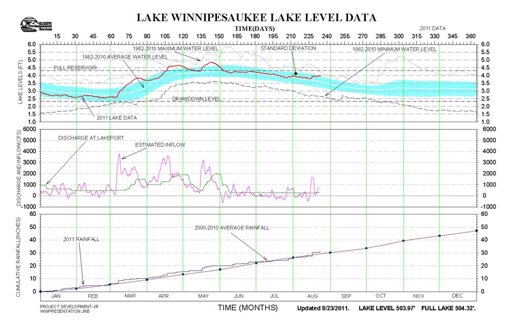 Link: Winnipesaukee Lake Level Data _________________________________ Link: Winnipesaukee Discharge Information Wednesday August 24th 6:00 am readings The level of Lake Winnipesaukee is at 503.95. The discharge at Lakeport Dam is 430 cfs, but will be increased to 1050 cfs later in the morning. Last edited by Rattlesnake Gal; 08-24-2011 at 12:21 PM. Reason: Resize Image |
|
|
|
|
08-24-2011, 11:51 AM
|
#14 |
|
Senior Member
Join Date: Apr 2004
Location: NH
Posts: 2,689
Thanks: 33
Thanked 439 Times in 249 Posts
|
The Bizer page links to this NH DES site:
http://www2.des.state.nh.us/RTi_Home...pesaukee#graph I very much doubt they will drop the lake more than a couple inches before the storm gets here. It looks we are about 6 inches above the mean for this date. That coupled with a pounding of rain from the storm will be troublesome. |
|
|
|
|
08-24-2011, 12:10 PM
|
#15 | |
|
Senior Member
Join Date: Apr 2004
Location: North Shore, MA
Posts: 1,356
Thanks: 991
Thanked 311 Times in 162 Posts
|
Quote:
Just click on the little green boxes. R2B |
|
|
|
|
|
08-24-2011, 01:03 PM
|
#16 |
|
Member
Join Date: Oct 2005
Posts: 33
Thanks: 0
Thanked 2 Times in 2 Posts
|
Thanks
Just had to look at the charts longer to understand them |
|
|
|
|
08-24-2011, 02:25 PM
|
#17 |
|
Senior Member
Join Date: Apr 2004
Posts: 501
Thanks: 12
Thanked 423 Times in 145 Posts
|
Subject: HSEM news release: Hurricane Irene Preparations
STATE OF NEW HAMPSHIRE Department of Safety Division of Homeland Security and Emergency Management NEWS RELEASE Wednesday, August 24, 2011 Contact: Jim Van Dongen, 603-223-3641 HSEM URGES PRECAUTIONS AS HURRICANE IRENE APPROACHES CONCORD, N.H. – Hurricane Irene, the 2011 Atlantic Hurricane Season’s first storm, is approaching the U.S. mainland and is expected to reach New England over the weekend. The N.H. Division of Homeland Security and Emergency Management recommends that New Hampshire residents and visitors stay current on storm watches and warnings and take precautions to protect themselves and their families. “Hurricanes pose dual threats: high winds that can down trees and power lines and heavy rain that can cause flooding,” said Christopher M, Pope, director of Homeland Security and Emergency Management. “Even if a hurricane is downgraded to a tropical storm or doesn’t directly strike New Hampshire it can push significant rainfall into the state. Flooding will be a serious threat.” Pope recommended the following hurricane precautions for all New Hampshire residents and visitors:
“People need to be aware of their surroundings and pay attention to local conditions that present a hazard during high winds or flooding,” Pope said. “I also encourage people to be good neighbors and check on elderly or handicapped relatives or acquaintances.” For detailed information on emergency preparedness for individuals, families, businesses and organization see the state emergency preparedness website, ReadyNH at www.readynh.nh.gov. |
|
|
|
|
08-24-2011, 03:54 PM
|
#18 |
|
Senior Member

Join Date: Apr 2004
Location: Kuna ID
Posts: 2,755
Thanks: 246
Thanked 1,942 Times in 802 Posts
|
Cell phone isn't going to do you any good if the cell towers loose power.
")
|
|
|
|
|
08-24-2011, 04:14 PM
|
#19 |
|
Senior Member

Join Date: Jan 2007
Location: Center Harbor
Posts: 1,049
Thanks: 15
Thanked 472 Times in 107 Posts
|
I've been waiting and watching, watching and waiting. Sunday is the day Irene would be here, lasting into Monday. BUT, it's too early to say "We're going to get a hurricane." It is NOT too early to take care of all those preparations that you should always have ready, at all times, anyway. Lots of people don't live prepared; and for them, times like this are the reminder to "do what you should have already done anyway."
So, if you're not one of those people who practices preparedness as a part of daily living, then now is a good time to start. Otherwise... at this point in time with Irene... 1) Remember that Gloria hit in 1985, Bob in 1991, and we're all still here. Neither storm was "nothing," so don't take any of these storms lightly. Downed wires and falling trees are dangerous, whether they fall in a hurricane or a random afternoon thunderstorm. 2) Remember that it doesn't have to be a big storm to make damage in the lakes region. R2B mentioned that local effects will play a role. In 1999, Tropical Storm Floyd ( a former major hurricane) passed east of New England. Almost everywhere got a wind-driven rainstorm, but the wind funneled between various mountain ranges and hills and amplified, creating pockets of major damage well inland. The coast was spared, by comparison. When I become more confident of Irene's track, I'll be able to talk about possible or likely *local* effects. In the meantime, plan on an early-season nor'easter with rain instead of snow. |
|
|
|
| The Following 7 Users Say Thank You to CanisLupusArctos For This Useful Post: | ||
DRH (08-24-2011), ishoot308 (08-24-2011), Jonas Pilot (08-24-2011), LIforrelaxin (08-25-2011), Ropetow (08-24-2011), Whimsey (08-25-2011), Winnisquamguy (08-24-2011) | ||
|
08-24-2011, 08:27 PM
|
#20 |
|
Senior Member

Join Date: Aug 2004
Location: Moultonborough & CT
Posts: 2,537
Thanks: 1,061
Thanked 653 Times in 364 Posts
|
Would driving from Nashua to Harttford, CT leaving at 9AM Sunday morning be a bad idea? Anyone?

|
|
|
|
|
08-24-2011, 08:30 PM
|
#21 | |
|
Senior Member
Join Date: Apr 2004
Location: North Shore, MA
Posts: 1,356
Thanks: 991
Thanked 311 Times in 162 Posts
|
Quote:
Stay safe! R2B |
|
|
|
|
|
08-24-2011, 10:01 PM
|
#22 |
|
Senior Member

Join Date: Nov 2002
Location: The Lakes, Central NH. and Dallas/Fort Worth TX.
Posts: 3,694
Blog Entries: 3
Thanks: 3,069
Thanked 472 Times in 236 Posts
|
R2B nailed it!.. If it were me, I wouldn't want to be traveling toward bad weather. However, a lot can happen between now and Sunday. Keep an eye on this one.
Storm track as of this evening from the weather channel;
__________________
trfour Always Remember, The Best Safety Device In The Boat, or on a PWC Snowmobile etc., Is YOU! Safe sledding tips and much more; http://www.snowmobile.org/snowmobiling-safety.html |
|
|
|
|
08-24-2011, 10:11 PM
|
#23 | |
|
Senior Member
Join Date: Apr 2004
Location: NH
Posts: 2,689
Thanks: 33
Thanked 439 Times in 249 Posts
|
Quote:
|
|
|
|
|
|
08-25-2011, 05:47 AM
|
#24 | |
|
Senior Member
Join Date: Apr 2004
Location: Eastern MA & Frye Island/Sebago Lake, Maine
Posts: 935
Thanks: 249
Thanked 323 Times in 148 Posts
|
Quote:
__________________
" Live for today because yesterday is gone and tomorrow may never come" |
|
|
|
|
|
08-25-2011, 07:31 AM
|
#25 |
|
Senior Member
Join Date: Aug 2004
Location: Moultonborough & CT
Posts: 2,537
Thanks: 1,061
Thanked 653 Times in 364 Posts
|
Thanks all! I will wait to see what the track of the storm does. As of this morning it doesn't look like it has changed much, but as you all say its too early to tell yet. I thought about the heavy rain but hadn't thought about downed wires and trees. Thanks.

|
|
|
|
|
08-25-2011, 09:06 AM
|
#26 |
|
Senior Member
Join Date: May 2006
Location: Long Island, not that one, the one on Winnipesaukee
Posts: 2,836
Thanks: 1,019
Thanked 885 Times in 518 Posts
|
So I was reading the reports for the National Huricane Center to be found here:
http://www.nhc.noaa.gov The report in full with what I believe to be important in bold: HURRICANE IRENE DISCUSSION NUMBER 20 NWS NATIONAL HURRICANE CENTER MIAMI FL AL092011 500 AM EDT THU AUG 25 2011 A HURRICANE HUNTER AIRCRAFT INVESTIGATING IRENE A FEW HOURS AGO FOUND THAT THE CENTRAL PRESSURE HAD DROPPED TO 950 MB. HOWEVER...FLIGHT-LEVEL AND SFMR-OBSERVED SURFACE WIND DATA SUPPORTED A CURRENT INTENSITY OF NO MORE THAN 100 KT...AND THIS IS PROBABLY GENEROUS. IT IS PRESUMED THAT THE INTENSIFICATION PROCESS WAS HALTED BY AN EYEWALL REPLACEMENT EVENT AS SUGGESTED BY MICROWAVE IMAGERY AND AIRCRAFT OBSERVATIONS. SINCE THE ENVIRONMENT APPEARS TO BE CONDUCIVE WITH WEAK SHEAR...WARM WATERS...AND AN UPPER-LEVEL OUTFLOW ANTICYCLONE OVER THE HURRICANE...THE OFFICIAL FORECAST SHOWS RE-STRENGTHENING WITHIN A DAY OR SO. AFTER A COUPLE OF DAYS...THE SHIPS GUIDANCE SHOWS A SIGNIFICANT INCREASE IN VERTICAL SHEAR...SO A STEADY DECREASE IN INTENSITY IS LIKELY. HOWEVER...SINCE IRENE HAS SUCH A LARGE AND INTENSE CIRCULATION...IT WILL PROBABLY BE RATHER SLOW TO WEAKEN. GIVEN THE LIMITATIONS IN OUR ABILITY TO PREDICT INTENSITY CHANGE...THERE IS SIGNIFICANT UNCERTAINTY AS TO JUST HOW STRONG IRENE WILL BE WHEN IT NEARS THE EASTERN AND NORTHEASTERN U.S. COAST. THE INITIAL MOTION CONTINUES TO BE ABOUT 315/10. THERE HAS BEEN NO CHANGE TO THE TRACK FORECAST REASONING. IRENE SHOULD TURN NORTHWARD AS IT MOVES THROUGH A BREAK IN THE SUBTROPICAL RIDGE DURING THE NEXT 48 HOURS. THEREAFTER...A SHORTWAVE TROUGH MOVING THROUGH THE GREAT LAKES IS LIKELY TO TURN THE HURRICANE TOWARD THE NORTH-NORTHEAST. IN THE LATTER PART OF THE FORECAST PERIOD...GLOBAL MODELS SHOW THE SHORTWAVE BYPASSING IRENE AND THE HURRICANE BECOMING EMBEDDED WITHIN A BROAD AND SLOW-MOVING MID-TROPOSPHERIC TROUGH OVER THE EASTERN UNITED STATES. THIS STEERING PATTERN SHOULD PREVENT IRENE FROM MOVING WELL OFFSHORE OF THE NORTHEASTERN STATES. THE OFFICIAL TRACK FORECAST HAS BEEN SHIFTED VERY SLIGHTLY TO THE WEST OF THE PREVIOUS ONE AND IS ROUGHLY IN THE MIDDLE OF THE GUIDANCE ENVELOPE...WHICH IS BRACKETED BY THE U.K. MET. OFFICE MODEL ON THE EAST AND THE GFDL MODEL ON THE WEST. HURRICANE AND TROPICAL STORM WATCHES ARE NOW NECESSARY FOR A PORTION OF THE SOUTHEAST AND CENTRAL U.S. EAST COAST. In short it looks like Irene will be coming for Dinner over the weekend....I plan to be at the camp for the storm to keep an eye on things. I will probably run some extra security lines to the boat for safety. And potentially take the Jet ski out of the water. I will also throw the lawn chairs and tables into the boat shed to prevent them from scattering.
__________________
Life is about how much time you can spend relaxing... I do it on an island that isn't really an island..... |
|
|
|
|
08-25-2011, 11:10 AM
|
#27 |
|
Senior Member
Join Date: May 2004
Location: Coral Gables, winter; Long Island, summer
Posts: 1,351
Thanks: 931
Thanked 570 Times in 296 Posts
|
There is a building site very near me with stuff strewn around as you would expect from a building site. Is there an obligation of the builder to secure the site to prevent flying debris as there is in FL?
__________________
"You're only young once, but you can be immature forever." |
|
|
|
|
08-26-2011, 02:43 PM
|
#28 |
|
Senior Member

Join Date: Apr 2004
Location: Moultonborough
Posts: 109
Thanks: 30
Thanked 16 Times in 11 Posts
|
according to the average of the various models on stormpulse.com, , the eye looks like it will pass...let's see...right over our house! We're down in MA...I just had a 3.5 hr. operation this AM. So to take the storm down here or up there? We're getting the power boat pulled, so that should be OK. But I couldn't do much up there anyway...right arm is in a sling for 4-6 weeks. Bad timing all the way around

|
|
|
|
|
08-26-2011, 08:57 PM
|
#29 |
|
Senior Member

Join Date: Jul 2009
Posts: 151
Thanks: 48
Thanked 61 Times in 35 Posts
|
I was in an office building in downtown Boston this week riding the earthquake out and would rather be up here riding the storm out. When Hurricane Bob rolled through I was up here on the Lake and it was not all that bad. Meanwhile, back down in MA the beaches were getting pounded.
|
|
|
|
|
08-26-2011, 11:44 PM
|
#30 |
|
Senior Member
Join Date: Jan 2007
Location: Center Harbor
Posts: 1,049
Thanks: 15
Thanked 472 Times in 107 Posts
|
It now appears that Irene will be downgraded to a tropical storm before it gets here.
However, it also appears that the eye will pass over, or very close to, this lake. That complicates the forecast -- a lot. Most of our effects from the storm are going to be localized, due to the many hills and mountains we have, as well as the wide-open expanse of the lake itself, which often serves as a runway for wind flow. These local effects are highly dependent on which direction the wind is blowing FROM. If wind hits one side of Gunstock or Red Hill, one thing happens. If it hits the other side, something very different happens. With the eye of the storm -- the center of the whole storm's counter-clockwise circulation -- expected to track right over the lake, that means the margin of error is equally to either side of the lake. --If it stays to the west of us, we'll get the strongest winds from the south and southwest. --If it passes east of us, we'll get the strongest winds from the northeast and north. --If it goes right over us, we'll get the strongest winds from the east AND the west -- with east winds suddenly dropping off to near calm, then coming back just as strong from the west. All three scenarios are a good possibility. This much is for sure: We're going to get a big wind-driven rain storm. Local effects (like hills, and the lake) are definitely going to play a role. What kind of role depends totally on what direction(s) the wind blows from. Here are some of the local effects that have decided our weather before: * The wind-facing side of any significant hill or mountain will get a lot more rain than the opposite side. The sides of hills facing away from the wind may get much lighter rain -- for as long as the wind stays blowing from the same direction. * A space between two mountain ranges, such as the Route 25 corridor between Red Hill and the Ossipee Range, can be a wind tunnel. When wind squeezes through there it increases in speed until it reaches the other side. This is not the only "wind tunnel" we have in the lakes region, but is just one easily-visible example. This particular wind tunnel is aligned north-south and works best with winds from those directions. * The lake itself, aligned NW-SE, has often served as a runway for ocean wind that is strong enough to reach Alton. If any weather is blowing in from the ocean and is strong enough to reach Alton, it can then follow the lake right up to Center Harbor. Locations just a mile north or south of the lake may not experience that weather at all. Wind on the lake reaches more of its potential because there isn't much friction with land to slow it down. By the time it goes from one end of the lake to the other, it's usually a lot faster than when it started out, and the waves underneath it are worthy of the ocean. * There are many points on the lake shore, and over 200 islands. When wind has to bend around them, it often increases dramatically in that location only. The main theme with Irene, for the lakes region, will be flooding and wind damage. We're no strangers to either threat here in NH. It happens all the time. What is different this time is that the storm is affecting such a large area of the nation that our usual cleanup help may be busy with their own areas. The kind of weather that Irene threatens to bring to NH is all stuff we've had recently, but not on the same day. 1. The Alstead floods and road washouts might happen again, in a different town. 2. A tornado like the Raymond-Barnstead-Effingham tornado of 2008 might happen again, on a different path. Tornadoes happen within tropical systems and their remnants. 3. Damage similar to the April 2007 Nor'easter may happen again, in different places. The question "Where?" is not one that can be answered in advance of the storm. Humans just can't do that. Statewide, there will probably be numerous roads closed due to flooding, downed trees and wires. Our summer thunderstorms bring that sort of thing all the time to individual locations while areas 10 miles away get nothing. Irene's damage will be over a much larger area. |
|
|
|
| The Following 6 Users Say Thank You to CanisLupusArctos For This Useful Post: | ||
Ropetow (08-28-2011), secondcurve (08-27-2011), SteveA (08-27-2011), Sunbeam lodge (08-27-2011), trfour (08-27-2011), winnitru (08-27-2011) | ||
|
08-27-2011, 05:03 AM
|
#31 |
|
Deceased Member

Join Date: Jul 2006
Location: Gilford, NH
Posts: 2,311
Thanks: 1,070
Thanked 2,054 Times in 497 Posts
|
http://www.nhc.noaa.gov/refresh/grap...track#contents
Moved just a little to the west from yesterdays track. I assume it could, (will?) move again before it actually arrives.
__________________
"Before you criticize someone, walk a mile in his shoes. That way, if he gets angry he'll be a mile away and barefoot!" unknown |
|
|
|
| The Following User Says Thank You to SteveA For This Useful Post: | ||
Jonas Pilot (08-27-2011) | ||
|
08-27-2011, 06:40 AM
|
#32 |
|
Senior Member
Join Date: Jul 2002
Location: Concord NH
Posts: 681
Thanks: 97
Thanked 48 Times in 39 Posts
|
O.K. Irene come on, Im ready and waiting

__________________
dont worry be happy 
|
|
|
|
|
08-27-2011, 07:15 AM
|
#33 |
|
Senior Member
Join Date: Apr 2005
Location: Wolfeboro, New Hampshire is my home, 24-7-365
Posts: 1,686
Thanks: 1,047
Thanked 336 Times in 189 Posts
|
Wind forecast Wolfeboro area.
Heavy Rain 7am --- 6pm Winds start to pick up around 7am to ~ 22 mph. Wind increase around 3pm 3pm 30+ mph east 4pm 35 mph east 5pm 39 mph east 6pm 40+ mph south east 7pm 50 mph ssw 8pm 50+ mph sw 9pm 45 mph wsw 10pm 35 mph west 11pm 25 mph west 12am 25 mph wnw |
|
|
|
|
08-27-2011, 07:51 AM
|
#34 |
|
Senior Member
Join Date: Aug 2004
Location: Moultonborough & CT
Posts: 2,537
Thanks: 1,061
Thanked 653 Times in 364 Posts
|
Made final decision not to make trip Sunday and ride out storm in CT. Looking at the anticipated path we're 3,000' to the west of it with home in CT and cottage in Moultonborough.

|
|
|
|
|
08-27-2011, 08:39 AM
|
#35 |
|
Senior Member
Join Date: Mar 2008
Location: Welch Island and West Alton
Posts: 3,262
Thanks: 1,202
Thanked 2,035 Times in 934 Posts
|
Info is on the Alton web site as to what to bring and general rules as to pets, etc.
http://alton.nh.gov/Main.asp |
|
|
|
|
08-27-2011, 08:40 AM
|
#36 | |
|
Senior Member
Join Date: Apr 2004
Location: Wayne, PA & Mirror Lake
Posts: 150
Thanks: 117
Thanked 17 Times in 15 Posts
|
Quote:
 But on the serious note, hope all works well for you and everyone there up north. We will arrive from Phila area maybe Tuesday. We may have issues down here. |
|
|
|
|
|
08-27-2011, 09:29 AM
|
#37 |
|
Senior Member

Join Date: Apr 2004
Location: North Reading, MA and South Down Shores
Posts: 850
Thanks: 57
Thanked 183 Times in 114 Posts
|
Hi all,
The following link is a wind speed calculator for locations along the path of Irene. Laconia will peak at about 6 pm tomorrow night at around 60 mph. http://www.boston.com/news/nation/sp...?p1=News_links Jetskeir 
|
|
|
|
| The Following 3 Users Say Thank You to jetskier For This Useful Post: | ||
|
08-27-2011, 02:27 PM
|
#38 | |
|
Senior Member
Join Date: Jan 2007
Location: Center Harbor
Posts: 1,049
Thanks: 15
Thanked 472 Times in 107 Posts
|
Quote:
The track forecast makes this a very difficult call for the lake. Farther away from the storm track, outside the margin of error, it's now easy to say which direction the wind will come from. But not here. |
|
|
|
|
| The Following 5 Users Say Thank You to CanisLupusArctos For This Useful Post: | ||
CGI3 (08-27-2011), Resident 2B (08-27-2011), secondcurve (08-27-2011), SteveA (08-27-2011), trfour (08-27-2011) | ||
|
08-27-2011, 05:11 PM
|
#39 |
|
Deceased Member
Join Date: Jul 2006
Location: Gilford, NH
Posts: 2,311
Thanks: 1,070
Thanked 2,054 Times in 497 Posts
|
Irene has moved west. New track has moved West. From the scale on the map, looks to be a 25-30 mile move to the West from the 5 AM track.
__________________
"Before you criticize someone, walk a mile in his shoes. That way, if he gets angry he'll be a mile away and barefoot!" unknown |
|
|
|
| The Following 3 Users Say Thank You to SteveA For This Useful Post: | ||
|
08-27-2011, 07:14 PM
|
#40 |
|
Senior Member
Join Date: Aug 2004
Location: Moultonborough & CT
Posts: 2,537
Thanks: 1,061
Thanked 653 Times in 364 Posts
|
Whew, now I have no worries.
At least about my Moultonborough home.
|
|
|
|
|
| Bookmarks |
|
|


 Hybrid Mode
