

|
|
|
|
|
|||||||
| Home | Forums | Gallery | Webcams | Blogs | YouTube Channel | Classifieds | Calendar | Register | FAQ | Donate | Members List | Today's Posts | Search |
 |
|
|
Thread Tools | Display Modes |
 02-23-2014, 09:09 PM
|
#1 |
|
Senior Member

Join Date: Jul 2002
Location: Massachusetts
Posts: 332
Thanks: 0
Thanked 242 Times in 81 Posts
|
Bizer had a meeting with the Marine Patrol on February 21st. I thought I'd share with you some of the changes that are in place for 2014 as well as anticipated changes.
What prompted the meeting was a phone call that Bizer received last fall. The Marine Patrol is considering decommissioning (removing) many buoys over the next few years. There are a fair number of buoys that have been around for eons and nobody knows whether the need exists. In many cases, it was a case of a shorefront owner knowing the Commissioner of Safety and having a buoy placed in front of the shorefront owner's property to keep boats away. The Marine Patrol will be creating a list of buoys they feel are superfluous. The Marine Patrol will be allowing the public to comment before actually removing the buoys. Meanwhile, the following buoy changes should be in place for the 2014 boating season.
Also: A boater asked me what happened to the bouy at the Barbers Pole. A buoy that looked like a barber's pole was placed just north of light #17 back in 2001. It was maintained by a local resident. That resident passed away and the family did not want to assume the responsibility of maintaining the buoy. It was removed as it had no navigational value. Last edited by Bizer; 02-25-2014 at 11:45 AM. |

|

|
| The Following 41 Users Say Thank You to Bizer For This Useful Post: | ||
@thelake (03-16-2014), AC2717 (02-24-2014), Aldidonato (02-24-2014), Alton Lady (02-24-2014), brk-lnt (02-24-2014), BroadHopper (02-25-2014), Broken Glass (03-04-2014), CaptT820 (02-25-2014), Cobalt (02-23-2014), Descant (03-01-2014), Electric man (02-24-2014), fugitivewife (02-28-2014), gillygirl (02-24-2014), Greene's Basin Girl (02-24-2014), Happy Gourmand (02-24-2014), HellRaZoR004 (02-24-2014), ishoot308 (02-24-2014), Just Sold (02-24-2014), Lakegeezer (02-24-2014), Lakewinn1 (03-14-2014), Misty Blue (03-03-2014), NHskier (02-24-2014), Orion (02-25-2014), PaugusBayFireFighter (02-24-2014), pcmc (02-25-2014), pjard (02-25-2014), polarisman14 (03-16-2014), Resident 2B (02-23-2014), rgilfert (02-25-2014), salty dog (02-24-2014), Sandy Island fan (02-24-2014), Slickcraft (02-24-2014), Sue Doe-Nym (02-24-2014), sum-r breeze (02-24-2014), Sunset Bob (03-11-2014), surfnsnow (02-24-2014), TiltonBB (02-24-2014), Tired of Waiting (02-24-2014), trfour (02-24-2014), upthesaukee (02-23-2014), webmaster (02-26-2014) | ||
|
02-24-2014, 04:55 PM
|
#2 | |
|
Senior Member

Join Date: May 2006
Location: Long Island, not that one, the one on Winnipesaukee
Posts: 2,824
Thanks: 1,015
Thanked 880 Times in 514 Posts
|
Quote:
There is one, that is often hard to see.....
__________________
Life is about how much time you can spend relaxing... I do it on an island that isn't really an island..... |
|
|
|
|
|
02-24-2014, 05:36 PM
|
#3 | |
|
Senior Member
Join Date: Jul 2002
Location: Massachusetts
Posts: 332
Thanks: 0
Thanked 242 Times in 81 Posts
|
Quote:
Of the three black-and-white buoys on the east side of Sandy Island, the northernmost buoy marks a rock that is three feet below the surface and was 10m west-southwest of the buoy when last surveyed in 2011. Last edited by Bizer; 02-25-2014 at 11:33 AM. |
|
|
|
|
|
02-24-2014, 05:58 PM
|
#4 |
|
Senior Member

Join Date: Apr 2004
Location: Bear Island
Posts: 1,757
Thanks: 31
Thanked 429 Times in 203 Posts
|
I wonder if they will remove the buoy at the southern point of Pine Island that keeps mysteriously moving itself away from shore. The Mount could pass inside that buoy without danger.
|
|
|
|
|
02-25-2014, 08:47 AM
|
#5 |
|
Senior Member
Join Date: Jun 2012
Location: Derry / Gilford
Posts: 1,220
Thanks: 68
Thanked 341 Times in 231 Posts
|
First, thanks for the information!
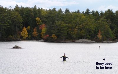
But sorry, I have to ask: Is that a penguin in the center of that picture? Or is it a lighted marker with solar panels on it?
__________________
Don't listen to me, obviously I don't understand what I'm talking about! Let's help each other save time and money: WinniGas.com |
|
|
|
| Sponsored Links |
|
|
|
02-25-2014, 09:37 AM
|
#6 | |
|
Senior Member
Join Date: May 2010
Posts: 412
Thanks: 211
Thanked 106 Times in 73 Posts
|
Quote:
|
|
|
|
|
|
02-25-2014, 11:10 AM
|
#7 |
|
Senior Member

Join Date: Apr 2004
Posts: 5,075
Thanks: 215
Thanked 903 Times in 509 Posts
|
The penguins are considered black top spars and should be navigated as such.

__________________
SIKSUKR |
|
|
|
|
02-25-2014, 11:43 AM
|
#8 | |
|
Senior Member
Join Date: Jul 2002
Location: Massachusetts
Posts: 332
Thanks: 0
Thanked 242 Times in 81 Posts
|
Quote:
Also, I originally forgot to mention in my original post:
|
|
|
|
|
|
02-25-2014, 11:59 AM
|
#9 |
|
Senior Member

Join Date: Oct 2004
Location: Laconia NH
Posts: 5,512
Thanks: 3,118
Thanked 1,090 Times in 784 Posts
|
Before 1996, to the right if the main beach was a popular rafting spot much like Braun Bay. When the state bought the property and add to the park, the buoys were placed to prevent rafting. For a long time boats were not allowed on the beach. I notice lately a number of pontoon boats beached to the furthest right looking toward land. Have there been a changed in policy?
__________________
Someday may never be an actual day. |
|
|
|
|
02-25-2014, 12:48 PM
|
#10 | |
|
Senior Member

Join Date: Jul 2004
Location: pine island of course!
Posts: 406
Thanks: 237
Thanked 245 Times in 112 Posts
|
Quote:
Question for Bizer - in your surveys do you track the placement and/or migration of buoys over time? ice is nice, but i'm ready for it to be just in my drinks -PIG |
|
|
|
|
|
02-25-2014, 03:11 PM
|
#11 | |
|
Senior Member
Join Date: Jun 2012
Location: Derry / Gilford
Posts: 1,220
Thanks: 68
Thanked 341 Times in 231 Posts
|
Quote:
It's good to know that NH Marine Patrol hasn't contracted the dreaded PC disease yet, so we still have a Nipple Rock on the lake! Does anyone know how often the MP checks the markers after ice out? Or are they not checked unless someone reports them?
__________________
Don't listen to me, obviously I don't understand what I'm talking about! Let's help each other save time and money: WinniGas.com |
|
|
|
|
|
02-25-2014, 05:12 PM
|
#12 | |
|
Senior Member
Join Date: May 2006
Location: Long Island, not that one, the one on Winnipesaukee
Posts: 2,824
Thanks: 1,015
Thanked 880 Times in 514 Posts
|
Quote:
__________________
Life is about how much time you can spend relaxing... I do it on an island that isn't really an island..... |
|
|
|
|
|
02-25-2014, 06:33 PM
|
#13 |
|
Senior Member
Join Date: Jan 2007
Posts: 64
Thanks: 81
Thanked 32 Times in 21 Posts
|
My husband - who's been staff/volunteer at camp for 50 years, told me that the marker on the north side has been missing for as much as 20 years - based on the age of his kids (how his memory works....) it could be more.
Last edited by Sandy Island fan; 02-25-2014 at 06:34 PM. Reason: clarification |
|
|
|
|
02-26-2014, 09:31 AM
|
#14 |
|
Senior Member

Join Date: Mar 2012
Location: Bedford, NH / Rattlesnake Island
Posts: 299
Thanks: 152
Thanked 227 Times in 57 Posts
|
It's great to know that the two copies of the new 2014 Duncan Press navigation chart that I just ordered are already out of date (and they haven't even arrived yet)!
|
|
|
|
|
02-26-2014, 10:09 AM
|
#15 |
|
Senior Member
Join Date: Jun 2012
Location: Derry / Gilford
Posts: 1,220
Thanks: 68
Thanked 341 Times in 231 Posts
|
How do you know they are out of date? Perhaps they also updated their charts with this information, did you email to ask them?

__________________
Don't listen to me, obviously I don't understand what I'm talking about! Let's help each other save time and money: WinniGas.com |
|
|
|
|
02-26-2014, 02:26 PM
|
#16 | |
|
Senior Member
Join Date: Mar 2012
Location: Bedford, NH / Rattlesnake Island
Posts: 299
Thanks: 152
Thanked 227 Times in 57 Posts
|
Quote:
|
|
|
|
|
|
02-26-2014, 05:19 PM
|
#17 |
|
Senior Member
Join Date: Jun 2012
Location: Derry / Gilford
Posts: 1,220
Thanks: 68
Thanked 341 Times in 231 Posts
|
And they are not showing pictures of Penquins standing on rocks!
__________________
Don't listen to me, obviously I don't understand what I'm talking about! Let's help each other save time and money: WinniGas.com |
|
|
|
|
02-27-2014, 10:06 PM
|
#18 |
|
Member
Join Date: Apr 2004
Posts: 32
Thanks: 1
Thanked 437 Times in 31 Posts
|
Thanks to Bizer for his post.
For those inquiring minds...Patrols begin shortly after ice-out but are limited. Officers report nav aids off station at this time. We also get many calls from the general public. We do not accept reports via email or this forum as we cant guarantee a timely review! Our goal is to have all lights and nav aids on station by Memorial Day Weekend. Also, Marine Patrol reaches out to all chart manufacturers when we are making significant changes to the nav aids. Obviously these changes extend beyond Winnipesaukee and involve a significant amount of effort. We thank all the chart manufacturers for their participation. We are looking to "phase-in" some new regulatory buoys as well as improve our posting of No Rafting areas in the next couple of seasons. We hope the improvements will make things better/easier for the boating public and have a positive influence on the budget! Safe Boating!! Tim Dunleavy |
|
|
|
| The Following 18 Users Say Thank You to Marine Patrol For This Useful Post: | ||
Alton Lady (03-02-2014), Barney Bear (02-28-2014), BroadHopper (03-02-2014), BunchesFormula (02-28-2014), Descant (03-01-2014), Diana (02-28-2014), Happy Gourmand (03-01-2014), Just Sold (02-28-2014), Misty Blue (03-03-2014), NHskier (02-28-2014), rgilfert (02-28-2014), Rich (02-28-2014), Sandy Island fan (02-28-2014), Sunset Bob (03-11-2014), tis (02-28-2014), trfour (02-28-2014), upthesaukee (02-28-2014), webmaster (02-28-2014) | ||
|
02-28-2014, 02:38 PM
|
#19 |
|
Senior Member
Join Date: Jun 2012
Location: Derry / Gilford
Posts: 1,220
Thanks: 68
Thanked 341 Times in 231 Posts
|
Thanks for what you do and making our boating safer!!
__________________
Don't listen to me, obviously I don't understand what I'm talking about! Let's help each other save time and money: WinniGas.com |
|
|
|
|
03-01-2014, 10:43 PM
|
#20 |
|
Senior Member
Join Date: Mar 2006
Location: Merrimack and Welch Island
Posts: 4,033
Thanks: 1,211
Thanked 1,511 Times in 983 Posts
|
I hope there will be postings here when the GPS chips are updated. In the meantime sounds like my 1956 tan and blue chart is coming back into favor.
Who remembers when there were three red buoys on the northeast side of the Hole in the Wall? The intent was to go close to shore either way, and around all three regardless of compass heading. Much confusion. Eventually the rocks and the buoys were removed. I guess the penguin protectors won't allow blowing up single rocks anymore, just as contractors can no longer mine the Witches for breakwater materials. We used to hear a story about a boat getting hung up in the middle of those three buoys and another boat putting great effort into pulling them off, to no avail. Eventually, as it started to get dark, they gave up and offerefed the men a ride. When the three men on board came to the gunwale to offload, the boat slid off the rock and they were on their way again. |
|
|
|
|
03-11-2014, 09:43 AM
|
#21 | |
|
Senior Member
Join Date: Jul 2002
Location: Massachusetts
Posts: 332
Thanks: 0
Thanked 242 Times in 81 Posts
|
Quote:
I would not consider these as major changes as the changes do not involve newly found navigation hazards. |
|
|
|
|
|
| Bookmarks |
|
|


 Linear Mode

