Quote:
Originally Posted by Old Hubbard Rd

Hello,
I am trying to zoom in on my property via these old maps. I am told that my property had a boat house at the shore and the foundation is still partially here. I would love to see what my home looked like with the boat house there. The address is 61 Old Hubbvard Rd Meredith. I could not get a clear view. Any suggestions? One day I will knock on some old timers doors in the neighborhood and ask for their help.
|
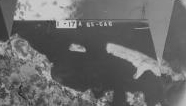
These old aerial photos will not have that level of detail. This is a crop from the composite aerial of Winni from 1954. Even zoomed and cropped you can see that there is no way to get that level of detail.
Here is the cropped and zoomed
Here is the original

__________________
"Before you criticize someone, walk a mile in his shoes. That way, if he gets angry he'll be a mile away and barefoot!" unknown
|